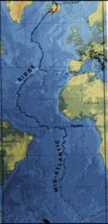
The Mid-Atlantic Ridge (MAR) is a mid-ocean ridge, a divergent tectonic plate or constructive plate boundary located along the floor of the Atlantic Ocean, and part of the longest mountain range in the world. In the North Atlantic it separates the Eurasian and North American plates, and in the South Atlantic it separates the African and South American plates. The ridge extends from a junction with the Gakkel Ridge northeast of Greenland southward to the Bouvet Triple Junction in the South Atlantic. Although the Mid-Atlantic Ridge is mostly an underwater feature, portions of it have enough elevation to extend above sea level. The section of the ridge that includes Iceland is known as the Reykjanes Ridge. The ridge has an average spreading rate of about 2.5 centimetres (0.98 in) per year.

Spaarndam is a small village in the province of North Holland, the Netherlands, on the Spaarne river and the IJ lake. The oldest part of the village, on the western side of the Spaarne, belongs to the municipality of Haarlem; the newer part on the eastern side is a part of the municipality of Haarlemmermeer. The village is built around a dam in the river, which is also the division line of the two municipalities.

Park e Shahr, literally the City Park, with its 26 hectares, is a major park located in the region 12th, central Tehran, Iran. It is surrounded by Fayaz Bakhsh Street from the north, Hafez Street from the west, Behesht Street from the south and Khayyam Street from the east.

Ribas de Sil is a town located in Galicia, in the Spanish province of Lugo. The monastery of Santo Estevo de Ribas de Sil, currently used as a Parador, is first mentioned in the 10th century, but is believed to have been founded here in between the 6th and 7th century.
This is a list of the extreme points and extreme elevations in Scotland.
The Findlay Group is a group of islands in the Canadian Arctic Archipelago in Qikiqtaaluk Region, Nunavut. This Arctic Ocean group consists of Lougheed Island, Stupart Island, Edmund Walker Island, Grosvenor Island and Patterson Island.
Moraújo is a municipality in the state of Ceará in the Northeast region of Brazil.

Carlópolis is a municipality in the state of Paraná in the Southern Region of Brazil.
Margaretting is a small village in the Chelmsford District, in the county of Essex, England. The population of the village taken at the 2011 Census was 847.
Boufatis is a town and commune in Oran Province, Algeria. According to the 1998 census it has a population of 9906.

Blériot Glacier is a short, but wide, glacier lying east of Salvesen Cove and Zimzelen Glacier and southwest of Cayley Glacier on Danco Coast, Graham Land in Antarctica. Photographed by the Falkland Islands and Dependencies Aerial Survey Expedition in 1956–57, and mapped from these photos by the Falkland Islands Dependencies Survey, it was named by the UK Antarctic Place-Names Committee in 1960 for Louis Blériot (1872–1936), a French aviator who in 1907 flew the first full-size powered monoplane, and who made the first flight across the English Channel in July 1909.
Phantom Point is a point within Darbel Bay, lying 1.5 nautical miles (2.8 km) west of Shanty Point on the west coast of Graham Land. Photographed by Hunting Aerosurveys Ltd. in 1955-57, and mapped from these photos by the Falkland Islands Dependencies Survey (FIDS). The name arose because the position of the point was only vaguely known when first visited by an FIDS sledge party in 1957, and it was obscured by thick fog from which it finally loomed like a phantom.

Eliason Glacier is a glacier 5 nautical miles (9 km) long close west of Mount Hornsby, flowing south from Detroit Plateau into the ice piedmont north of Larsen Inlet, Nordenskjöld Coast in northern Graham Land, Antarctica. It was mapped from surveys by the Falkland Islands Dependencies Survey (1960–61), and was named by the UK Antarctic Place-Names Committee after the Eliason motor sledge, invented in 1942 in Sweden, now made in Canada, and used in Arctic Canada since 1950 and in the Antarctic since 1960.
Snick Pass is a narrow mountain pass lying between the Douglas Range and the LeMay Range, leading from Grotto Glacier to Purcell Snowfield in the central portion of Alexander Island, Antarctica. The feature was first mapped from air photos obtained by the Ronne Antarctic Research Expedition in 1947–48, by Searle of the Falkland Islands Dependencies Survey in 1960. The name given by the United Kingdom Antarctic Place-Names Committee is descriptive, a snick being a small cut or incision.

Las Palmas Glacier is a glacier flowing west-northwest from Hurd Dome and terminating at Las Palmas Cove, South Bay, Livingston Island, Antarctica. The name was given by the Spanish Antarctic Expedition, about 1991, after the ship Las Palmas of the Spanish Antarctic campaigns since 1988.
Papilaid is an island belonging to the country of Estonia.

National Cycle Network (NCN) Route 647 is a Sustrans National Route that runs from Clumber Park to Harby 53.233°N 0.683°W. The route is 19.6 miles (31.5 km) in length and is fully open and signed in both directions.


