
Chouteau County is a county located in the North-Central region of the U.S. state of Montana. As of the 2010 United States Census, the population was 5,813. Its county seat is Fort Benton. The county was established in 1865 as one of the original nine counties of Montana, and named in 1882 after Pierre Chouteau Jr., a fur trader who established a trading post that became Fort Benton, which was once an important port on the Missouri River.
Arrow Creek is a tributary of the Missouri River in Montana in the United States. Approximately 45 miles (73 km) long, it rises in the Lewis and Clark National Forest near Highwood Baldy in the Highwood Mountains in southern Chouteau County. It flows south then east, then northeast and joins the Missouri in the White Cliffs Area on the border between Chouteau and Fergus counties.

René-Auguste Chouteau, Jr., also known as Auguste Chouteau, was the founder of St. Louis, Missouri, a successful fur trader and a politician. He and his partner had a monopoly for many years of fur trade with the large Osage tribe on the Missouri River. In addition, he had numerous business interests in St. Louis and was well-connected with the various rulers: French, Spanish and American.
Chouteau was the name of a highly successful, ethnically French fur-trading family based in Saint Louis, Missouri, which they helped to found. Its members established posts in the Midwest and Western United States, particularly along the Missouri River and in the Southwest. Various locations were named after this family.

The Ste. Genevieve Limestone is a geologic formation named for Ste. Genevieve, Missouri where it is exposed and was first described. It is a thick-bedded limestone that overlies the St. Louis Limestone. Both are Mississippian in age. The St. Louis Limestone is Meramecian and the Ste. Genevieve is the base of the Chesterian series.
François Gesseau Chouteau was an American pioneer fur trader, businessman and community leader known as the "Founder" or "Father" of Kansas City, Missouri.

Chouteau Island, situated approximately eight miles (13 km) due north of the Gateway Arch in St. Louis, Missouri, and approximately one mile (1.6 km) south of the confluence of the Missouri River and Mississippi River, is one of a cluster of three islands: Chouteau Island, Gabaret Island, and Mosenthein Island. The three, with a combined area of approximately 5,500 acres (20 km2), are located in Madison County, Illinois. The three-island complex is also referred to as "Chouteau Island". The island is manmade, having been created during the construction of the Chain of Rocks Canal between 1946 and 1953. Most of Chouteau Island lies in Chouteau Township, but its southern quarter lies in Venice Township, both in Madison County. Gabaret Island and Mosenthein Island both lie entirely in Venice Township.

Pierre Chouteau Jr., also referred to as Pierre Cadet Chouteau, was an American merchant and a member of the wealthy Chouteau fur-trading family of Saint Louis, Missouri.

The Maquoketa Group is an assemblage of several geologic formations. It is Upper Ordovician in age and named for the Maquoketa River in Iowa. It exists in Missouri, Wisconsin, Iowa, Illinois, and Indiana. It is equivalent to the all but the basal formations of the Cincinnati Group in Ohio. Illinois and Indiana are the only states where the Maquoketa is considered a group. In other states it is a formation. The Maquoketa was deposited in a shallow intercontinental sea. Most of the clastic sediments are derived from the Appalachians, which were being raised at the end of the Ordovician. To a lesser degree some of the sediments were derived from the Ozark highlands to the southwest.
The Missouri Fur Company was one of the earliest fur trading companies in St. Louis, Missouri. Dissolved and reorganized several times, it operated under various names from 1809 until its final dissolution in 1830. It was created by a group of fur traders and merchants from St. Louis and Kaskaskia, Illinois, including Manuel Lisa and members of the Chouteau family. Its expeditions explored the upper Missouri River and traded with a variety of Native American tribes, and it acted as the prototype for fur trading companies along the Missouri River until the 1820s.
The Chouteau Limestone is a geologic formation in Illinois, Iowa, Kansas, and Missouri. It preserves fossils dating back to the Carboniferous period.
The Maquoketa Formation is a geologic formation in Illinois, Indiana. Iowa, Kansas, Minnesota, Missouri, and Wisconsin. It preserves mollusk, coral, brachiopod and graptolite fossils dating back to the Ordovician period.
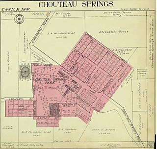
Chouteau Springs is an unincorporated community in Pilot Grove Township, Cooper County, in the U.S. state of Missouri.
Chouteau Township is an inactive township in Clay County, in the U.S. state of Missouri.
Chouteau Township is the name of two townships in the United States:

Glacial Lake Glendive was a glacial lake on the lower Yellowstone River. It formed in the valley of Yellowstone, during the late Pleistocene epoch south of the Keewatin Ice Sheet. As the ice sheet retreated northward, the lake drained into the modern Missouri River.

Lake Jordan was a glacial lake formed during the late Pleistocene along the Jordan River. After the Laurentide Ice Sheet retreated, water melting off the glacier accumulated between the Rocky Mountains and the ice sheet. The lake drained along the front of the ice sheet, eastward towards the Yellowstone River and Glacial Lake Glendive.

Before the Pleistocene Ice Age, circa two million years before present (YBP), the rivers in North, South Dakota and eastern Montana drained northeast into Canada and then into Hudson Bay. The Keewatin Lobe of the continental ice sheet, block the flow of water northward and impounded it along the ice front. Lakes formed, until the waters could find a new way to drain. Initially, the north flowing rivers followed the front of the glacier eastward and into a valley that passed between Garrison and Riverdale, to the Turtle Lake area, and on into Sheridan County. This is known as the preglacial McClean River. This valley became blocked by the glacier and the glacial lake identified as Lake McKenzie formed. Eventually, water level rose to crest the south ridge a point near Riverdale — at the site of the modern Garrison Dam and a diversion trench was cut. The modern Missouri River follows this pathway.
Lake Circle was a glacial lake that formed during the late Pleistocene epoch along the Redwater River in eastern Montana. After the Laurentide Ice Sheet retreated, glacial ice melt accumulated in the basin surrounded by the ridges of the preglacial valley and the retreating glacier. Southwest of Nickwall are the remnants of a broad abandoned valley with long side slopes. The valley runs north from Redwater Creek to the Missouri River. The bottom is poorly drained and about 1 mile (1.6 km) in width. It lies 2,015 to 2,020 feet above the sea level and 40 to 50 feet above the Missouri River bottomland. The upland slopes are extensive, clear and flat. The valleys surrounding it are dissected with V-shaped coulees. The difference between the Redwater valley and those around it reflect stream erosion vs. lake sedimentation. The drift in the valleys, appears to be as left by the glacier in the previously created valleys. Using the dating of lake deposits near Great Falls, Montana, the Havre lobe of the Laurentide Ice Sheet dammed the ancestral Missouri River during the late Wisconsin Glacial Period.
Lake Chouteau was a glacial lake formed during the late Pleistocene along the Teton River. After the Laurentide Ice Sheet retreated, water melting off the glacier accumulated between the Rocky Mountains and the ice sheet. The lake drained along the front of the ice sheet, eastward towards the Judith River and the Missouri River.