Church and Watt Street Terrace Group

Last updated

Church and Watt Street Terrace Group
273 - Church and Watt Street Terrace Group - PCO Plan Number 273 (5053343p1).jpg
Heritage boundaries
LocationChurch Street, Newcastle, City of Newcastle, New South Wales, Australia
Coordinates 32°55′48″S151°46′59″E / 32.9299°S 151.7830°E / -32.9299; 151.7830
Architectural style(s) Victorian Filigree
OwnerJejeep Pty Ltd; Johnpat Nominees Pty Ltd; Kiap Bros Transport Pty Ltd; Kiztwo Pty Ltd
Official nameChurch and Watt Street Terrace Group
Typestate heritage (complex / group)
Designated2 April 1999
Reference no.273
TypeTerrace
CategoryResidential buildings (private)
Australia New South Wales relief location map.png
Red pog.svg
Location of Church and Watt Street Terrace Group in New South Wales

The Church and Watt Street Terrace Group is a heritage-listed precinct along Church and Watt Streets, Newcastle, City of Newcastle, New South Wales, Australia. It was added to the New South Wales State Heritage Register on 2 April 1999. [1]

Contents

Description

The precinct includes four neighbouring sites listed as constituent elements: [1]

273 - Church and Watt Street Terrace Group (5053343b1).jpg Grand Hotel at 32 Church Street [2]
273 - Church and Watt Street Terrace Group (5053343b2).jpg Buchanan Terraces at 10-30 Church Street [3]
273 - Church and Watt Street Terrace Group (5053343b3).jpg Macquarie House at 8 Church Street [4]
273 - Church and Watt Street Terrace Group (5053343b4).jpg Watt Street terraces at 50-62 Watt Street [5]

Heritage listing

The Church and Watt Street Terrace Group was listed on the New South Wales State Heritage Register on 2 April 1999. [1]

See also

Related Research Articles

<span class="mw-page-title-main">Newcastle, New South Wales</span> City in New South Wales, Australia

Newcastle, also commonly referred to as Greater Newcastle is a regional metropolitan area and the second-most-populous district of New South Wales, Australia. It includes the cities of Newcastle and Lake Macquarie and it is the hub of the Lower Hunter region, which includes most parts of the cities of Newcastle, Lake Macquarie, Maitland, Cessnock, and Port Stephens Council. Newcastle is also known by its colloquial nickname, Newy.

<span class="mw-page-title-main">The Rocks, New South Wales</span> Suburb of Sydney, New South Wales, Australia

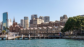
The Rocks is a suburb, tourist precinct and historic area of Sydney's city centre, in the state of New South Wales, Australia. It is located on the southern shore of Sydney Harbour, immediately north-west of the Sydney central business district.

<span class="mw-page-title-main">Randwick, New South Wales</span> Suburb of Sydney, New South Wales, Australia

Randwick is a suburb in the Eastern Suburbs of Sydney, in the state of New South Wales, Australia. Randwick is located 6 kilometres south-east of the Sydney central business district and is the administrative centre for the local government area of the City of Randwick. The postcode is 2031.

<span class="mw-page-title-main">Windsor, New South Wales</span> Town in New South Wales, Australia

Windsor is a historic town in north-west of Sydney, New South Wales, Australia. It is the council seat of the Hawkesbury local government area. The town sits on the Hawkesbury River, enveloped by farmland and Australian bush. Many of the oldest surviving European buildings in Australia are located at Windsor. It is 56 km (35 mi) north-west of the Sydney CBD, on the fringes of urban sprawl.

<span class="mw-page-title-main">City of Blue Mountains</span> Local government area in New South Wales, Australia

The City of Blue Mountains is a local government area of New South Wales, Australia, governed by the Blue Mountains City Council. The city is located in the Blue Mountains, on the Great Dividing Range at the far western fringe of the Greater Sydney area. Major settlements include, Katoomba, Lawson, Springwood and Blaxland.

<span class="mw-page-title-main">Millers Point, New South Wales</span> Suburb of Sydney, New South Wales

Millers Point is an inner-city suburb of Sydney, in the state of New South Wales, Australia. It is on the north-western edge of the Sydney central business district, adjacent to The Rocks and is part of the local government area of the City of Sydney.

<span class="mw-page-title-main">City of Lithgow</span> Local government area in New South Wales, Australia

The City of Lithgow is a local government area in the Central West region of New South Wales, Australia. The area is located adjacent to the Great Western Highway and the Main Western railway line.

<span class="mw-page-title-main">City of Orange (New South Wales)</span> Local government area in New South Wales, Australia

The City of Orange is a local government area in the Central West region of New South Wales, Australia. Based in Orange, the area is located adjacent to the Mitchell Highway and the Main Western railway line.

East Maitland is a suburb in Maitland, New South Wales, Australia. It is on the New England Highway and it has two railway stations, Victoria Street and East Maitland. Both stations are served by NSW TrainLink. Hunter Valley Buses provides bus service.

<span class="mw-page-title-main">Newcastle Civic Theatre</span> Cinema in New South Wales, Australia

The Newcastle Civic Theatre, also known as The Civic, is a heritage-listed building located on Hunter Street, Newcastle, Australia. Opened in 1929, the 1520-seat theatre is now the venue for a wide range of musicals, plays, concerts and dance events each year and is the city's oldest surviving theatre.

<span class="mw-page-title-main">The Hill, New South Wales</span> Suburb of Newcastle, New South Wales, Australia

The Hill is an inner city, residential suburb of Newcastle, in the Hunter Region of New South Wales, Australia, located immediately south of Newcastle's central business district. The Hill is filled with historic Victorian terraces and is the site of a historic convict prison block. As of January 2021, the average house price in The Hill was A$1.92m.

<span class="mw-page-title-main">Walter Liberty Vernon</span> English architect

Colonel Walter Liberty Vernon was an English architect who migrated to Australia and pursued his career as an architect in Sydney, New South Wales. In his role as the New South Wales Government Architect he is noted for designing multiple government buildings, many of which are extant with listings on national and state heritage registers.

<span class="mw-page-title-main">Mortimer Lewis</span> English-born architect, surveyor and public servant (1796–1879)

Mortimer William Lewis was an English-born architect, surveyor and public servant who migrated to Australia and became Colonial Architect in the colony of New South Wales from 1835 to 1849. Lewis was responsible for designing and overseeing many government buildings in Sydney and rural New South Wales, many of which are heritage listed.

<span class="mw-page-title-main">Nobbys Head Light</span> Lighthouse in New South Wales, Australia

Nobbys Head Light is an active lighthouse on Nobbys Head, a headland on the south side of the entrance to Newcastle Harbour, New South Wales, Australia. An image of the lighthouse is included in the coat of arms of the City of Newcastle.

<span class="mw-page-title-main">Armidale Regional Council</span> Local government area in New South Wales, Australia

The Armidale Region is a local government area in the New England and Northern Tablelands regions of New South Wales, Australia. This area was formed in 2016 from the merger of the Armidale Dumaresq Shire with the surrounding Guyra Shire.

<span class="mw-page-title-main">90-92 Windmill Street, Millers Point</span> Historic site in New South Wales, Australia

90–92 Windmill Street, Millers Point is a heritage-listed historic site located at 90–92 Windmill Street, in the inner city Sydney suburb of Millers Point in the City of Sydney local government area of New South Wales, Australia. It was added to the New South Wales State Heritage Register on 2 April 1999.

<span class="mw-page-title-main">18-20a Munn Street, Millers Point</span> Historic site in New South Wales, Australia

18–20a Munn Street is a heritage-listed row of terrace houses located at 18, 18a, 20, 20a Munn Street, in the inner city Sydney suburb of Millers Point in the City of Sydney local government area of New South Wales, Australia. It was added to the New South Wales State Heritage Register on 2 April 1999.

<span class="mw-page-title-main">Merriman Street Terraces</span> Historic site in New South Wales, Australia

The Merriman Street Terraces are heritage-listed terrace houses located at 20–48 Merriman Street, in the inner city Sydney suburb of Millers Point in the City of Sydney local government area of New South Wales, Australia. It is also known as Davies Terrace. The property was added to the New South Wales State Heritage Register on 2 April 1999.

<span class="mw-page-title-main">Eagleton Terrace</span> Historic site in New South Wales, Australia

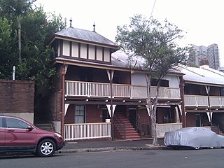
The Eagleton Terrace are heritage-listed terrace houses located at 67–73 Lower Fort Street, in the inner city Sydney suburb of Millers Point in the City of Sydney local government area of New South Wales, Australia. The property was added to the New South Wales State Heritage Register on 2 April 1999.
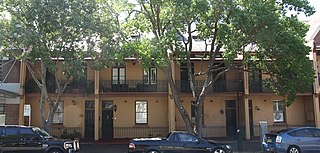
References

  1. 1 2 3 "Church and Watt Street Terrace Group". New South Wales State Heritage Register . Department of Planning & Environment. H00273. Retrieved 1 June 2018. CC BY icon.svg Text is licensed by State of New South Wales (Department of Planning and Environment) under CC-BY 4.0 licence .
  2. "Grand Hotel". New South Wales State Heritage Register . Department of Planning & Environment. H00273. Retrieved 1 June 2018. CC BY icon.svg Text is licensed by State of New South Wales (Department of Planning and Environment) under CC-BY 4.0 licence .
  3. "Buchanan Terraces and Footpath". New South Wales State Heritage Register . Department of Planning & Environment. H00273. Retrieved 1 June 2018. CC BY icon.svg Text is licensed by State of New South Wales (Department of Planning and Environment) under CC-BY 4.0 licence .
  4. "Macquarie House". New South Wales State Heritage Register . Department of Planning & Environment. H00273. Retrieved 1 June 2018. CC BY icon.svg Text is licensed by State of New South Wales (Department of Planning and Environment) under CC-BY 4.0 licence .
  5. "Watt Street terraces". New South Wales State Heritage Register . Department of Planning & Environment. H00273. Retrieved 1 June 2018. CC BY icon.svg Text is licensed by State of New South Wales (Department of Planning and Environment) under CC-BY 4.0 licence .

Attribution

CC BY icon-80x15.png This Wikipedia article was originally based on Church and Watt Street Terrace Group , entry number 00273 in the New South Wales State Heritage Register published by the State of New South Wales (Department of Planning and Environment) 2018 under CC-BY 4.0 licence , accessed on 1 June 2018.