
The North Shore is part of the urban area of Auckland, New Zealand, located to the north of the Waitematā Harbour.

Takanini is a suburb of Auckland, in northern New Zealand. It is located on the shores of the Pahurehure Inlet, 28 kilometres southeast of the Auckland CBD.
Ellerslie is a suburb of the city of Auckland, in the North Island of New Zealand. It is a small but dynamic town centre with a strong community spirit. Ellerslie lies seven kilometres to the southeast of the city centre, close to State Highway 1, and has a population of 8667. Administratively, Ellerslie forms part of the Orakei Local Board, which also includes the suburbs of Orākei, Mission Bay, Kohimarama, Saint Heliers, Glendowie, Saint Johns, Meadowbank and Remuera. To the west, Ellerslie borders on the One Tree Hill area and Cornwall Park. Largely a residential suburb, the area is arguably best-known as the site of Auckland's main horse-racing venue, Ellerslie Racecourse, as well as the original site of the Ellerslie Flower Show.
Western Springs is a residential suburb and park in the city of Auckland in the north of New Zealand. It is located four kilometres to the west of the city centre, Auckland CBD. The park is situated to the north of State Highway 16 and the residential suburb is located southeast of the park on the opposite side of State Highway 16.

Glen Innes is a suburb in East Auckland, New Zealand, located nine kilometres to the east of the city centre, close to the waters of the Tamaki River estuary.

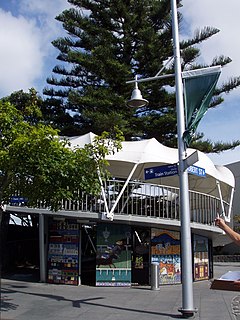
Mission Bay is a seaside suburb of Auckland city, on the North Island of New Zealand, with a population of 5469. The suburb's beach is a popular resort, located alongside Tamaki Drive. The area also has a wide range of eateries. Mission Bay is located seven kilometres to the east of the city centre, on the southern shore of the Waitemata Harbour, between Orakei and Kohimarama. It covers an area of 1.08 km2, about three quarters of which comprises low hills, surrounding the remaining quarter, which slopes down to the sea. Local government of Mission Bay is the responsibility of the Orakei Local Board, which also includes the suburbs of Orakei, Kohimarama, St Heliers, Glendowie, St Johns, Meadowbank, Remuera and Ellerslie.
Glendowie is a suburb in Auckland, New Zealand. It is under the local governance of Auckland Council. It was formerly under Auckland City Council from 1989 until the merger of all of Auckland's councils into the 'super city' in 2010.
Kohimarama is a coastal residential Auckland suburb, located to the east of the city, with many homes having some of the best views across the Auckland Harbour. Kohimarama is situated between Mission Bay and St Heliers and has an accessible beach with a boardwalk and green recreational spaces located amongst residential areas. According to the 2013 census, Kohimarama has a population of 7092. Local government of Kohimarama is the responsibility of the Orākei Local Board, which also includes the suburbs of Orakei, Mission Bay, St Heliers, Glendowie, St Johns, Meadowbank, Remuera and Ellerslie.

Meadowbank is a suburb of Auckland city, in the North Island of New Zealand.
Wai o Taiki Bay is a small Auckland suburb bordering Glen Innes, Glendowie and the Tamaki River estuary. Its name is based on the original name of the Tamaki River, Te Wai o Taiki, meaning "The Waters of Taiki". The name Taiki is a shortened form of Taikehu, the name of an ancestor of Ngāi Tai.
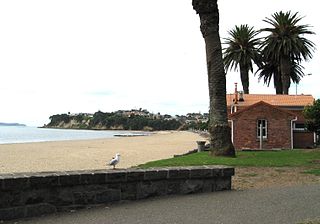
Saint Heliers is an affluent seaside suburb of Auckland with a population of 4824. This suburb is popular amongst visitors for the beaches, cafés, and views of Rangitoto Island, the distinctive volcanic island in the Hauraki Gulf.
East Auckland is an area of Auckland, New Zealand, characterised in the popular mind as a socio-economically mixed urban area with a relatively large multi-cultural population. The name "East Auckland" is not an official placename, but is in popular use by New Zealanders. It is also used in the names of some organisations and companies. Coverage and connotations of the name are not precisely defined and vary somewhat with the user.

Flat Bush is a suburb in Auckland, and is New Zealand's largest and most comprehensively planned new town, taking shape on 1700 hectares in south east Auckland. An Auckland Council transformation project, Flat Bush will be home to at least 40,000 people by 2025, a similar population to Nelson, and includes five neighbourhood centres. Located near Manukau Heights the council has planned for the area to undergo substantial development since buying 290 hectares there in 1996. While most of Flat Bush is being developed by the private sector, Auckland Council is guiding the overall development of the area to ensure people, places and the environment are given emphasis. The suburb contains the 94 hectare "Barry Curtis Park", named in recognition of Manukau's longest standing mayor, Barry Curtis, with a development programme stretching into the 2020s. A neighbouring 20 hectare town centre will be developed starting in 2010, and planning is underway for subdivision of another 440 hectares. Building of houses has started next to Barry Curtis Park as of 2012. More land in the area is going to be developed over the next few years by Todd Property Group.

Barry Curtis Park is a new park named after Barry Curtis in Flat Bush, Manukau City of which the first stage was opened in April 2009. At 94 hectares, it is one of New Zealand's largest parks, of a size as has not been established since the Auckland Domain in the 1840s.

The City Rail Link (CRL) is a rail project currently under construction in Auckland, New Zealand. The $4.4 billion project consists of the construction of a 3.5 km long double-track rail tunnel underneath Auckland's city centre, between Britomart Transport Centre and Mount Eden Railway Station. Two new underground stations will be constructed to serve the city centre: Aotea near Aotea Square and Karangahape near Karangahape Road. Britomart will be converted from a terminus station into a through station and Mount Eden Station will be completely rebuilt with four platforms to serve as an interchange between the new CRL line and the existing Western Line.
Ōrākei Ward is one of thirteen wards of Auckland Council in Auckland, New Zealand. It encompasses the neighbourhoods of Saint Heliers, Glendowie, Kohimarama, Mission Bay, Saint Johns and Meadowbank. It elects one councillor to represent the ward on the council. The councillor has oversight over the Orakei Local Board. The current councillor is Desley Simpson.

Maungarei / Mount Wellington is a 135-metre volcanic peak located in the Auckland volcanic field of Auckland, New Zealand. It is the youngest onshore volcano of the Auckland volcanic field, having been formed by an eruption around 10,000 years ago. It is the largest of Auckland's scoria cones and has a near-circular base with a flattish rim and three small fire-fountaining craters. It is situated in the Mount Wellington suburb of East Auckland.


