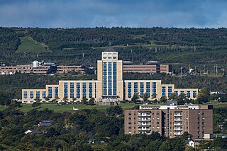
Memorial University, or MUN, is a public research university in the province of Newfoundland and Labrador, based in St. John's, with satellite campuses in Corner Brook, Happy Valley-Goose Bay, Saint Pierre, and Harlow, England. Memorial University offers certificate, diploma, undergraduate, graduate, and post-graduate programs, as well as online courses and degrees.

The Fisheries andMarine Institute of Memorial University of Newfoundland, popularly referred to as the Marine Institute (MI) or simply Marine, is a post-secondary ocean and marine polytechnic located in St. John's, Newfoundland and Labrador, Canada. It is affiliated with Memorial University of Newfoundland.
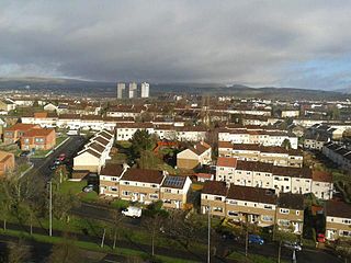
Blairdardie is a neighbourhood in the Scottish city of Glasgow. It is situated north of the River Clyde in the north-west of the city and is surrounded by other residential areas: High Knightswood, Knightswood, Old Drumchapel, Drumchapel and Garscadden. It was built between the 1950s and early 1960s.

The University of Dayton Student Neighborhood, located in Dayton, Ohio, is home to upperclassmen at the University of Dayton (UD). Formerly known as "the Ghetto," the UD Student Neighborhood is leased in an arrangement that resembles both traditional university housing and a landlord/tenant relationship. Tracing its history back to the 1870s, the neighborhood now includes more than 200 university-owned houses as well as landlord-owned houses, high-density housing and gathering spaces. With the inclusion of Holy Angels and The Darkside, or officially "the North Student Neighborhood", two smaller neighborhoods the university owns property in, there are more than 400 houses currently used as student residential space. Because of the area's age, the university has been engaged in a program to renovate and update the houses, and several additional changes to the neighborhood are expected in the coming years as part of the university's Master Plan.
The Goulds is a designated place in the Canadian province of Newfoundland and Labrador. It is a rural neighbourhood within the City of St. John's southeast of the city centre.
A student quarter or a student ghetto is a residential area, usually in proximity to a college or university, that houses mostly students. Due to the youth and relative low income of the students, most of the housing is rented, with some cooperatives. Landlords have little incentive to properly maintain the housing stock, since they know that they can always find tenants. Non-students tend to leave the area because of the noise and raucous behavior of the students. Property crimes, sexual assaults, and noise and drug violations are more common in student quarters.
The Confederation Building serves as the home of the Newfoundland and Labrador House of Assembly. It is located on Confederation Hill overlooking Newfoundland and Labrador's capital city, St. John's. The brick- and concrete-clad building has 11 stories and is 64 metres (210 ft) tall. It was completed in 1960 at a cost of $9 million to replace the Colonial Building. A lantern is located at the top of the copper roof of the central tower and acts as a beacon when turned on at night.

Lawrence Manor is a neighbourhood in the city of Toronto, Ontario, Canada. This neighbourhood is bounded by Bathurst Street on the east, Highway 401 to the north, the Allen to the west, and Lawrence Avenue to the south. The western side of the area borders along Bathurst Heights and the large public housing project.

Pippy Park is a 3,400-acre (14 km2) urban park located in the city of St. John's, Newfoundland. The park is a popular camping, hiking and recreational park within the city, and incorporates numerous groomed and wilderness-style hiking/skiing trails, a miniature golf course, a 9-hole and an 18-hole golf course, a driving range, and a public access trailer park with limited tent camping facilities. Trails within the park link to the Grand Concourse walking trails.

Rabbittown is a neighbourhood in St. John's, Newfoundland and Labrador. It is located near downtown, and is bounded approximately by Empire Avenue, Freshwater Road and Newtown Road.
The Newfoundland T'Railway Provincial Park is a rail trail located in the Canadian province of Newfoundland and Labrador.
Strathcona is a residential neighbourhood in south central Edmonton, Alberta, Canada. It is a part of, and should not be confused with, Old Strathcona, although much of the Strathcona neighbourhood is in Old Strathcona. The neighbourhood overlooks both the North Saskatchewan River and the Mill Creek Ravine.

The neighborhoods of Albany, New York are listed below.

Georgestown is a Neighbourhood Improvement Area in St. John's, Newfoundland and Labrador a short distance north from downtown of St. John's. This was established in the 1970s as part of an effort by Federal and local government to improve inner cities. Originally what was known as Georgestown village was much smaller and only "extended from Donnelly's Lane to what is now Belvedere Street". The neighbourhood improvement area includes, in addition to the original Georgestown, the former Monkstown and Tubridtown, along with adjoining land, including Circular Road, and Belvedere Street as well as some other parts of the former Belvedere Estate. It is bordered by Military Road, Monkstown Road, Empire Avenue, a small part of Carpasian Road, the east side of Bonaventure Avenue, and Holy Heart and Brother Rice Schools to the west. It was settled, around 1819, as the city's first suburb. The name is an evolution of "George (Winter)'s Town", as it was known in the 19th century.
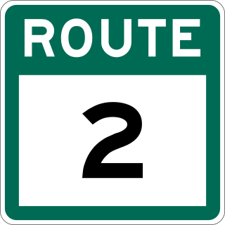
Route 2, also known as Pitts Memorial Drive and Peacekeeper's Way, is a 34.2-kilometre-long (21.3 mi) freeway on the Avalon Peninsula of Newfoundland in the Canadian province of Newfoundland and Labrador. The road provides a direct link from the Trans-Canada Highway (TCH) to downtown St. John's, Newfoundland, which was previously accessible only via city streets such as Topsail Road or Kenmount Road. Initially called the Harbour Arterial, construction began in the early 1970s and was completed in 1979. The $52-million project was funded by the federal and provincial governments. It was renamed by the city council in 1984 after local businessman James Stewart Pitt (1847-1914).
Virginia Park is a neighbourhood in the northeast end of St. John's, Newfoundland and Labrador.

The Parkway is a major arterial road in the city of St. John's, Newfoundland and Labrador. It consists of three distinct roads that form a single through route: Columbus Drive, Prince Philip Drive, and Macdonald Drive. A four-lane expressway with a speed limit of 70 km/h along most of its length, the parkway begins at an intersection with Pitts Memorial Drive in the city's west end and terminates at Logy Bay Road in the east end.
The neighbourhood of Buckmaster's Circle is located in central area of St. John's, Newfoundland and Labrador, Canada.
Grenfell Campus, formerly Sir Wilfred Grenfell College, is a campus of the Memorial University of Newfoundland (MUN). It is located in the city of Corner Brook, Newfoundland and Labrador, Canada. The campus has approximately 1,300 students enrolled in degree programs for the arts, education, fine arts, science, resource management and nursing. Many students from around the province also attend the school for the first- and second-year course offerings before transferring to Memorial University's larger campus in St. John's.
Churchill Meadows is a suburban residential neighbourhood located in the westernmost area of Mississauga, Ontario, Canada. In 2016, Churchill Meadows had a population of 47,800. Postal codes in this area are L5M. The official neighbourhood boundaries for Churchill Meadows are Highway 407 to the west, Britannia Road to the North, Winston Churchill Boulevard to the east and Highway 403 to the south. It is located adjacent to Erin Mills and near the Erin Mills Town Centre. A large community centre, and sports park, Churchill Meadows Community Centre is located in the neighbourhood.
