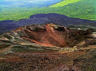
Cerro Negro is an active volcano in the Cordillera de los Maribios mountain range in Nicaragua, about 10 km from the village of Malpaisillo. It is a very new volcano, the youngest in Central America, having first appeared in April 1850. It consists of a gravelly basaltic cinder cone, which contrasts greatly with the surrounding verdant hillsides, and gives rise to its name, which means Black Hill. Cerro Negro has erupted frequently since its first eruption. One unusual aspect of several eruptions has been the emission of ash from the top of the cone, while lava erupts from fractures at the base.

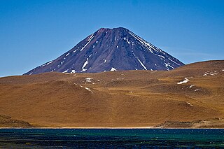
Licancabur is a stratovolcano on the border between Bolivia and Chile, south of the Sairecabur volcano and west of Juriques. Part of the Andean Central Volcanic Zone, it has a prominent, 5,916-metre (19,409 ft)-high cone. A 400-metre (1,300 ft) summit crater containing Licancabur Lake, a crater lake which is among the highest lakes in the world, caps the volcano. Three stages of lava flow emanate from the volcano, which formed on Pleistocene ignimbrites.

Aracar is a large conical stratovolcano in northwestern Argentina, just east of the Chilean border. It has a main summit crater about 1–1.5 kilometres (0.6–0.9 mi) in diameter which sometimes contains crater lakes, and a secondary crater. The volcano has formed, starting during the Pliocene, on top of a lava platform and an older basement. Constructed on a base with an altitude of 4,100 metres (13,500 ft), it covers a surface area of 192.4 square kilometres (74.3 sq mi) and has a volume of 148 cubic kilometres (36 cu mi). The only observed volcanic activity was a possible steam or ash plume on March 28, 1993 seen from the village of Tolar Grande about 50 km (31 mi) southeast of the volcano, but with no evidence of deformation of the volcano from satellite observations. Inca archeological sites are found on the volcano.

Cerro Escorial is a stratovolcano at the border of Argentina and Chile. It is part of the Corrida de Cori volcanic group and its youngest member. A well-preserved 1-kilometre-wide (0.6 mi) crater forms its summit area. Lava flows are found on the Chilean and smaller ones on the Argentinian side, the former reaching as far as 3–4 kilometres (1.9–2.5 mi) from the volcano. One of these is dated 342,000 years ago by argon-argon dating.

Cerro Azul, sometimes referred to as Quizapu, is an active stratovolcano in the Maule Region of central Chile, immediately south of Descabezado Grande. Part of the South Volcanic Zone of the Andes, its summit is 3,788 meters (12,428 ft) above sea level, and is capped by a summit crater that is 500 meters (1,600 ft) wide and opens to the north. Beneath the summit, the volcano features numerous scoria cones and flank vents.

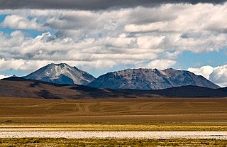
Incahuasi is a volcanic mountain in the Andes of South America. It lies on the border of the Argentine province of Catamarca, and the Atacama Region of Chile. Incahuasi has a summit elevation of 6,621 metres (21,722 ft) above sea level.

Nevado de Longaví is a volcano in the Andes of central Chile. The 3,242 m (10,636 ft) high volcano lies in the Linares Province, which is part of the Maule Region. It features a summit crater and several parasitic vents. The volcano is constructed principally from lava flows. Two collapses of the edifice have carved collapse scars into the volcano, one on the eastern slope known as Lomas Limpias and another on the southwestern slope known as Los Bueye. The volcano features a glacier and the Achibueno and Blanco rivers originate on the mountain.

Descabezado Grande is a stratovolcano located in the Maule Region of central Chile. It is capped by a 1.4-kilometre-wide (0.9 mi) ice-filled caldera and named for its flat-topped form, as descabezado means "headless" in Spanish. A smaller crater about 500 metres (1,600 ft) wide is found in the northeast part of the caldera, and it has active fumaroles.

Aucanquilcha(pronounced: OW-kahn-KEEL-chuh) is a massive stratovolcano located in the Antofagasta Region of northern Chile, just west of the border with Bolivia and within the Alto Loa National Reserve. Part of the Central Volcanic Zone of the Andes, the stratovolcano has the form of a ridge with a maximum height of 6,176 metres (20,262 ft). The volcano is embedded in a larger cluster of volcanoes known as the Aucanquilcha cluster. This cluster of volcanoes was formed in stages over eleven million years of activity with varying magma output, including lava domes and lava flows. Aucanquilcha volcano proper is formed from four units that erupted between 1.04–0.23 million years ago. During the ice ages, both the principal Aucanquilcha complex and the other volcanoes of the cluster were subject to glaciation, resulting in the formation of moraines and cirques.

Miñiques is a massive volcanic complex containing a large number of craters, lava domes and flows, located in the Antofagasta Region of Chile. Located 21 km (13 mi) south of Volcán Chiliques and 26 km (16 mi) west of Cordón Puntas Negras, it is part of a frequently visited attraction conformed by the high plain lagoons Laguna Miscanti, Laguna Miñiques and the Cerro Miscanti volcano.
Chiliques is a stratovolcano located in the Antofagasta Region of Chile.

Paniri is a stratovolcano located in El Loa Province, Antofagasta Region, Chile, and near the border with Bolivia. To its northwest lie the twin volcanoes San Pedro and San Pablo, and to its southeast lies Cerro del León, from which it is separated by the huge Chao lava dome.
Cerros de Tocorpuri is a volcanic complex located along the border between Bolivia and Chile.

Putana, sometimes referred to as Jorqencal or Machuca, is a volcano on the border between Bolivia and Chile and close to the Sairecabur volcanic complex. Part of the Central Volcanic Zone of the Andes, its summit is 5,890 metres (19,320 ft) above sea level and contains a summit crater with two smaller craters nested within it. Beneath the summit, the volcano features a number of lava domes and lava flows, some of which originated in flank vents.
Cerro del León is a stratovolcano located in El Loa province, Antofagasta Region, Chile. It is part of the Chilean Central Volcanic Zone and forms a volcanic lineament with neighbouring Paniri and Toconce that was active into the Holocene. Cerro del León itself was constructed in three stages by andesitic–dacitic lava flows and was subject to glacial erosion.
Tilocalar are two volcanoes in the Central Volcanic Zone of the Andes. They are constructed on Pleistocene ignimbrites and are 3.5 kilometres (2.2 mi) afar. Tilocálar Sur is a 3,116 metres (10,223 ft) high polygenetic volcano and has an explosion crater one kilometre to the south. Two other craters are also present along a graben. Four basaltic andesite-andesite lava flows emanate from it. Tilocálar Norte is a 3,040 metres (9,970 ft) high monogenetic system and generated northbound lava flows that run along the eastern wall of the Callejón de Tilocálar. Based on the age of the underlying Tucucaro ignimbrite the volcano is less than 3.2 million years old. An andesitic dyke swarm is associated with this system.
Crater Basalt volcanic field is a volcanic field in Argentina in the Chubut province.

Acamarachi is a 6,046-metre (19,836 ft) high volcano in northern Chile. In this part of Chile, it is the highest volcano. Its name means "black moon". It is a volcano in the Central Volcanic Zone of the Andes, a zone of strong volcanic activity during the last million years. Old volcanoes in the area are well-preserved, due to the dry climate.

Olca-Paruma is a volcanic complex in Chile. Lying on the border between Chile and Bolivia, it is formed by an east-west alignment of volcanoes. From west to east, these are Cerro Paruma, Volcan Paruma, Olca, and Mencheca or Michincha. Aside from the mines of Ujina, Rosario, and Quebrada Blanca, the area is sparsely populated.

Apacheta-Aguilucho volcanic complex is a volcanic complex in Chile. It consists of two volcanoes Cerro Apacheta and Cerro Aguilucho, which are constructed mainly by lava flows and surrounded by outcrops of lava. A sector collapse and its landslide deposit are located on Apacheta's eastern flank. Two lava domes are associated with the volcanic complex, Chac-Inca and Pabellón.