
Ağstafa is a town and municipality in, and the capital of, the Agstafa Rayon of Azerbaijan. Historically it was a train station.

The arrondissement of Château-Thierry is an arrondissement of France in the Aisne department in the Hauts-de-France region. Since the January 2017 reorganization of the arrondissements of Aisne, it has 108 communes.

The arrondissement of Nontron is an arrondissement of France in the Dordogne department in the Nouvelle-Aquitaine region. Since the January 2017 reorganization of the arrondissements of Dordogne, it has 100 communes.
The Canton of Brantôme is a canton of the Dordogne department, in France. The lowest point is 63 m, the highest point is at 251 m. At the French canton reorganisation which came into effect in March 2015, the canton of Brantôme was expanded from 11 to 42 communes :
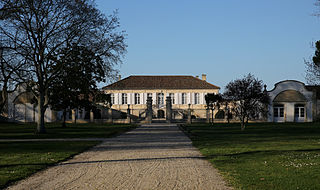
Château Pichon Longueville Comtesse de Lalande is a winery in the Pauillac appellation of the Bordeaux region of France. Château Pichon Longueville Comtesse de Lalande is also the name of the red wine produced by this property. The wine produced here was classified as one of fifteen Deuxièmes Crus in the original Bordeaux Wine Official Classification of 1855.
Château La Lagune is a winery in the Haut-Médoc appellation of the Bordeaux region of France. The wine produced here was classified as one of fourteen Troisièmes Crus in the historic Bordeaux Wine Official Classification of 1855.
Château Marquis de Terme is a winery in the Margaux appellation of the Bordeaux region of France. The wine produced here was classified as one of ten Quatrièmes Crus in the historic Bordeaux Wine Official Classification of 1855.
Ayrens is a commune in the Cantal department in the Auvergne region of south-central France.

Fontaneda is a village in Andorra, located in the parish of Sant Julià de Lòria.
The Châteaux de Curemonte are three castles in the commune of Curemonte, in the Corrèze département of France.
There are numerous castles in the Aveyrondépartement of France. Many are little more than ruins and some are barely discernible, while others have been converted into modern homes. Castles or their remains may be found at the following locations, among others:
The Parc naturel régional Périgord Limousin was created March 9, 1998. It consists of 78 communes situated in the Dordogne and Haute Vienne départements. The park has a surface area of 1800 square kilometers and is inhabited by 49 661 people.

Château Léoville-Poyferré is a winery in the Saint-Julien appellation of the Bordeaux region of France. Château Léoville-Poyferré is also the name of the red wine produced by this property. The wine produced here was classified as one of fifteen Deuxièmes Crus in the original Bordeaux Wine Official Classification of 1855.
Tsaouni is a village and rural commune in Niger.
The Mareuil Anticline, also called Mareuil-Meyssac Anticline, is a structural high within the sedimentary sequence of the northeastern Aquitaine Basin. The northwest-southeast trending anticline was caused by tectonic movements probably starting in the Upper Cretaceous.
Château de Faye is the name of several castles in France, including:

The Château de la Faye in Saint-Sulpice-de-Mareuil, France, is an 18th-century French château built by the enlargement of a 16th-century structure, in Saint-Sulpice-de-Mareuil in the Dordogne département, France.
The canton of Val de Nouère is an administrative division of the Charente department, southwestern France. It was created at the French canton reorganisation which came into effect in March 2015. Its seat is in Linars.
The canton of Mareuil-sur-Lay-Dissais is an administrative division of the Vendée department, western France. Its borders were modified at the French canton reorganisation which came into effect in March 2015. Its seat is in Mareuil-sur-Lay-Dissais.


