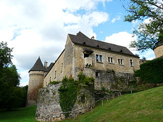
The Château de la Faye is a French castle located in Auriac-du-Périgord, in the Dordogne department of France. [1]
Auriac-du-Périgord is a commune in the Dordogne department in Nouvelle-Aquitaine in southwestern France.
Dordogne is a department in Southwestern France, with its prefecture in Périgueux. The department is located in the region of Nouvelle-Aquitaine between the Loire Valley and the Pyrenees and is named after the river Dordogne that runs through it. It corresponds roughly with the ancient county of Périgord. It had a population of 416,909 in 2013.
France, officially the French Republic, is a country whose territory consists of metropolitan France in Western Europe and several overseas regions and territories. The metropolitan area of France extends from the Mediterranean Sea to the English Channel and the North Sea, and from the Rhine to the Atlantic Ocean. It is bordered by Belgium, Luxembourg and Germany to the northeast, Switzerland and Italy to the east, and Andorra and Spain to the south. The overseas territories include French Guiana in South America and several islands in the Atlantic, Pacific and Indian oceans. The country's 18 integral regions span a combined area of 643,801 square kilometres (248,573 sq mi) and a total population of 67.3 million. France, a sovereign state, is a unitary semi-presidential republic with its capital in Paris, the country's largest city and main cultural and commercial centre. Other major urban areas include Lyon, Marseille, Toulouse, Bordeaux, Lille and Nice.
The castle was originally a simple defensive tower built in the 13th century for the defence of Montignac. Towers were later added on the south side—the one on the left in 1359, and the one on the right in the 15th century. [2] [3] The castle is recorded in 1476 as the Faya Fortalitium.
Montignac, also called Montignac sur Vézère or Montignac-Lascaux, is a commune in the Dordogne department in Nouvelle-Aquitaine in southwestern France. It is a small town situated on the Vézère river and has been the capital of the canton of Montignac since 1790. In 2015 it became the capital of the newly created Canton de la Vallée de l'Homme. The poet Pierre Lachambeaudie (1806–1872) was born in the village.
The dwelling portion of the structure dates from the end of the 15th century, consisting of three levels. A tower, which is highlighted by an arched door opening onto the stairs, was added in the 16th century. [4] [5] In the 18th century there were alterations to the roof, including skylights.
A skylight is a light-transmitting structure that forms all or part of the roof space of a building for daylighting purposes.
It is today a listed monument. [6]
The Château de Beynac is a castle situated in the commune of Beynac-et-Cazenac, in the Dordogne département of France. The castle is one of the best-preserved and best known in the region.
Sainte-Orse is a commune in the Dordogne department in Nouvelle-Aquitaine in southwestern France. The church of Saint Ursus dates from the 11th-12th century. The castle dates from the 15th-16th century.
Léguillac-de-l'Auche is a commune in the Dordogne department in Nouvelle-Aquitaine in southwestern France.
Manzac-sur-Vern is a commune in the Dordogne department in Nouvelle-Aquitaine in southwestern France.
Saint-Amand-de-Coly is a commune in the Dordogne department in Nouvelle-Aquitaine in southwestern France.
The Château d'Agonac is a former castle, converted into a château, in the commune of Agonac in the Dordogne département of France.
The Château de la Bonnetie is a château in the commune of Sarliac-sur-l'Isle in Dordogne, Nouvelle-Aquitaine, France.
The Château des Bories is a château at Antonne-et-Trigonant in Dordogne, Nouvelle-Aquitaine, France. The castle dates back to the late 15th and early 16th century. It has fortified towers, a monumental staircase and a dry moat. It is the home of the Lary de Latour family.
The Château de La Chapelle-Faucher is a château in La Chapelle-Faucher, Dordogne, Aquitaine, France.
The Château de Condat is a fortified former commandry of the Knights Hospitaller located in the commune of Condat-sur-Vézère in the Dordogne département of France.
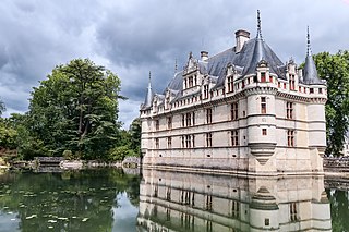
The Château d'Azay-le-Rideau is located in the town of Azay-le-Rideau in the French département of Indre-et-Loire. Built between 1518 and 1527, this château is considered one of the foremost examples of early French renaissance architecture. Set on an island in the middle of the Indre river, this picturesque château has become one of the most popular of the châteaux of the Loire valley.
Bourglinster Castle is located in the village of Bourglinster in central Luxembourg some 17 km (11 mi) to the east of Luxembourg City. Now housing a restaurant and facilities for business and cultural gatherings, the castle has a history stretching back to the 11th century.
The Château de Fayolle is a château in Tocane-Saint-Apre, Dordogne, Nouvelle-Aquitaine, France.
The Château de Lalinde is a château, developed from a 13th-century castle, in the commune of Lalinde in the Dordogne département of France. It is known locally as le château de la Bastide.
The Château de Lanmary is a château in Antonne-et-Trigonant, Dordogne, Nouvelle-Aquitaine, France, constructed around four 15th-century towers.
The Château de Mauriac is a château in Dordogne, Nouvelle-Aquitaine, France. It is listed as a Monument historique.
The Château de la Petite Filolie is a château in Condat-sur-Vézère, Dordogne, Nouvelle-Aquitaine, France. It stands on the River Vézère directly opposite the Château de la Fleunie.
Château de la Valade is a château in Bourdeilles, Dordogne, Nouvelle-Aquitaine, France.
The Château de la Faye is a manor house in Villexavier, in the Charente-Maritime region of France.
Coordinates: 45°06′18″N1°07′34″E / 45.1051°N 1.1262°E
A geographic coordinate system is a coordinate system that enables every location on Earth to be specified by a set of numbers, letters or symbols. The coordinates are often chosen such that one of the numbers represents a vertical position and two or three of the numbers represent a horizontal position; alternatively, a geographic position may be expressed in a combined three-dimensional Cartesian vector. A common choice of coordinates is latitude, longitude and elevation. To specify a location on a plane requires a map projection.