
The Colorado Plateau, also known as the Colorado Plateau Province, is a physiographic and desert region of the Intermontane Plateaus, roughly centered on the Four Corners region of the southwestern United States. This province covers an area of 336, 700 km2 (130,000 mi2) within western Colorado, northwestern New Mexico, southern and eastern Utah, and northern Arizona. About 90% of the area is drained by the Colorado River and its main tributaries: the Green, San Juan, and Little Colorado. Most of the remainder of the plateau is drained by the Rio Grande and its tributaries.

The exposed geology of the Canyonlands area is complex and diverse; 12 formations are exposed in Canyonlands National Park that range in age from Pennsylvanian to Cretaceous. The oldest and perhaps most interesting was created from evaporites deposited from evaporating seawater. Various fossil-rich limestones, sandstones, and shales were deposited by advancing and retreating warm shallow seas through much of the remaining Paleozoic.

The exposed geology of the Capitol Reef area presents a record of mostly Mesozoic-aged sedimentation in an area of North America in and around Capitol Reef National Park, on the Colorado Plateau in southeastern Utah.

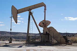
Oil reserves denote the amount of crude oil that can be technically recovered at a cost that is financially feasible at the present price of oil. Hence reserves will change with the price, unlike oil resources, which include all oil that can be technically recovered at any price. Reserves may be for a well, a reservoir, a field, a nation, or the world. Different classifications of reserves are related to their degree of certainty.
The Cutler Formation or Cutler Group is a rock unit that is spread across the U.S. states of Arizona, northwest New Mexico, southeast Utah and southwest Colorado. It was laid down in the Early Permian during the Wolfcampian stage. Its subunits, therefore, are variously called formations or members depending on the publication. Members :

The San Juan Basin is a geologic structural basin located near the Four Corners region of the Southwestern United States. The basin covers 7,500 square miles and resides in northwestern New Mexico, southwestern Colorado, and parts of Utah and Arizona. Specifically, the basin occupies space in the San Juan, Rio Arriba, Sandoval, and McKinley counties in New Mexico, and La Plata and Archuleta counties in Colorado. The basin extends roughly 100 miles N-S and 90 miles E-W.

The Uinta Basin is a physiographic section of the larger Colorado Plateaus province, which in turn is part of the larger Intermontane Plateaus physiographic division. It is also a geologic structural basin in eastern Utah, east of the Wasatch Mountains and south of the Uinta Mountains. The Uinta Basin is fed by creeks and rivers flowing south from the Uinta Mountains. Many of the principal rivers flow into the Duchesne River which feeds the Green River—a tributary of the Colorado River. The Uinta Mountains forms the northern border of the Uinta Basin. They contain the highest point in Utah, Kings Peak, with a summit 13,528 feet above sea level. The climate of the Uinta Basin is semi-arid, with occasionally severe winter cold.

The Naturita Formation is a Cretaceous Period sedimentary geologic formation, found in western Colorado and eastern Utah.

The Piceance Basin is a geologic structural basin in northwestern Colorado, in the United States. It includes geologic formations from Cambrian to Holocene in age, but the thickest section is made up of rocks from the Cretaceous Period. The basin contains reserves of coal, natural gas, and oil shale. The name likely derives from the Shoshoni word /piasonittsi/ meaning “tall grass”.
The Cisco Springs Oil and Gas Field is located in Grand County, Utah at 39°04′30″N109°21′19″W.

The Williston Basin is a large intracratonic sedimentary basin in eastern Montana, western North Dakota, South Dakota, and southern Saskatchewan, that is known for its rich deposits of petroleum and potash. The basin is a geologic structural basin but not a topographic depression; it is transected by the Missouri River. The oval-shaped depression extends approximately 475 miles (764 km) north-south and 300 miles (480 km) east-west.
Fred F. Meissner was an American geologist and engineer who contributed to the fields of geology, geophysics, engineering, petroleum engineering, geochemistry, mineralogy, physics, mining, economic geology, and fishing.
Tin Cup Oil Field is located in San Juan County, approximately 21 miles (34 km) southeast of Blanding, Utah. Production is from a northwest–southeast trending 120-foot-thick (37 m) carbonate buildup in the Pennsylvanian Upper Ismay. The field is part of the Paradox Basin that extends from the states of Colorado to Utah and New Mexico.

Greentown Oil and Gas Field is located in Grand County, approximately 26 miles (42 km) southwest of the city of Green River, Utah.

The Pennsylvanian to Lower Permian,, Supai Group, is a slope-forming section of red bed deposits found at the southwest-to-south Colorado Plateau. Cliff-forming interbeds (sandstone) are noticeable throughout the group, as well as the largest cliff-former the topmest member Esplanade Sandstone. The Supai Group is especially exposed throughout the Grand Canyon in northwest Arizona, as well as local regions of southwest Utah. It outcrops southeastwards in Arizona at Chino Point, Sycamore Canyon, and famously at Sedona as parts of Oak Creek Canyon. In the Sedona region, it is overlain by the Hermit Formation, and the colorful Schnebly Hill Formation.

The Persian Gulf Basin, is found between the Eurasian and the Arabian Plates. The Persian Gulf is described as a shallow marginal sea of the Indian Ocean that is located between the south western side of Iran and the Arabian Peninsula and south and southeastern side of Oman and the United Arab Emirates. Other countries that border the Persian Gulf basin include; Saudi Arabia, Qatar, Kuwait, Bahrain and Iraq. The Gulf extends a distance of 1000 km with an area of 240,000 square km. The Persian Gulf basin is a wedge-shaped foreland basin which lies beneath the western Zagros thrust and was created as a result of the collision between the Arabian and Eurasian plates.
The geology of Utah includes rocks formed at the edge of the proto-North American continent during the Precambrian. A shallow marine sedimentary environment covered the region for much of the Paleozoic and Mesozoic, followed by dryland conditions, volcanism and the formation of the basin and range terrain in the Cenozoic. Utah is a state in the western United States.
The geology of Colorado was assembled from island arcs accreted onto the edge of the ancient Wyoming Craton. The Sonoma orogeny uplifted the ancestral Rocky Mountains in parallel with the diversification of multicellular life. Shallow seas covered the regions, followed by the uplift current Rocky Mountains and intense volcanic activity. Colorado has thick sedimentary sequences with oil, gas and coal deposits, as well as base metals and other minerals.
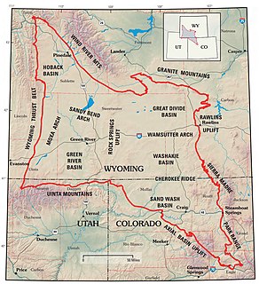
The Greater Green River Basin (GGRB) is a 21,000 square mile basin located in Southwestern Wyoming. The Basin was formed during the Cretaceous period sourced by underlying Permian and Cretaceous deposits. The GGRB is host to many anticlines created during the Laramide Orogeny trapping many of its hydrocarbon resources. It is bounded by the Rawlins Uplift, Uinta Mountains, Sevier overthrust belt, Sieria Madre Mountains, and the Wind River Mountain Range. The Greater Green River Basin is subdivided into four smaller basins the Green River Basin, Great Divide Basin, Washakie Basin, and Sand Wash Basin. Each of which possesses hydrocarbons that have been economically exploited. There are 303 named fields throughout the basin the majority of which produce natural gas, the largest of these gas fields is the Jonah Field.
Morgan C.D., 1999, Petroleum geology of the Cisco Townsite and Cisco Wash Areas, Grand County, Utah, Utah Geological Survey, Oil and Gas Field Study 22
Morgan C.D., 2001, Petroleum geology of the Agate, Danish Wash, Sage, and Seiber nose reservoirs in the Greater Cisco Field Area, Utah Geological Survey, Field Study 23
Tedesco, S. A., 2013, Geology and seismic interpretation of the Cisco Springs area, Uncompahgre Uplift, Grand County, Utah, AAPG Rocky Mountain Section 62nd Annual Meeting, Salt Lake City, UT September 22–24, 2013, Search and Discovery Article 90169.


