Related Research Articles

Richard Buckminster Fuller was an American architect, systems theorist, writer, designer, inventor, philosopher, and futurist. He styled his name as R. Buckminster Fuller in his writings, publishing more than 30 books and coining or popularizing such terms as "Spaceship Earth", "Dymaxion", "ephemeralization", "synergetics", and "tensegrity".

An invention is a unique or novel device, method, composition, idea or process. An invention may be an improvement upon a machine, product, or process for increasing efficiency or lowering cost. It may also be an entirely new concept. If an idea is unique enough either as a stand-alone invention or as a significant improvement over the work of others, it can be patented. A patent, if granted, gives the inventor a proprietary interest in the patent over a specific period of time, which can be licensed for financial gain.

A geodesic dome is a hemispherical thin-shell structure (lattice-shell) based on a geodesic polyhedron. The rigid triangular elements of the dome distribute stress throughout the structure, making geodesic domes able to withstand very heavy loads for their size.
The Dymaxion House was developed by inventor and architect Buckminster Fuller to address several perceived shortcomings with existing homebuilding techniques. Fuller designed several versions of the house at different times—all of them factory manufactured kits, assembled on site, intended to be suitable for any site or environment and to use resources efficiently. A key design consideration was ease of shipment and assembly.

The Dymaxion map or Fuller map is a projection of a world map onto the surface of an icosahedron, which can be unfolded and flattened to two dimensions. The flat map is heavily interrupted in order to preserve shapes and sizes.

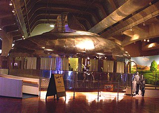
The Dymaxion car was designed by American inventor Buckminster Fuller during the Great Depression and featured prominently at Chicago's 1933/1934 World's Fair. Fuller built three experimental prototypes with naval architect Starling Burgess – using donated money as well as a family inheritance – to explore not an automobile per se, but the 'ground-taxiing phase' of a vehicle that might one day be designed to fly, land and drive – an "Omni-Medium Transport". Fuller associated the word Dymaxion with much of his work, a portmanteau of the words dynamic, maximum, and tension, to summarize his goal to do more with less.
World Game, sometimes called the World Peace Game, is an educational simulation developed by Buckminster Fuller in 1961 to help create solutions to overpopulation and the uneven distribution of global resources. This alternative to war games uses Fuller's Dymaxion map and requires a group of players to cooperatively solve a set of metaphorical scenarios, thus challenging the dominant nation-state perspective with a more holistic "total world" view. The idea was to "make the world work for 100% of humanity in the shortest possible time through spontaneous cooperation without ecological damage or disadvantage to anyone," thus increasing the quality of life for all people.

James Tennant Baldwin, often known as Jay Baldwin or J. Baldwin, was an American industrial designer and writer. Baldwin was a student of Buckminster Fuller; Baldwin's work was inspired by Fuller's principles and, in the case of some of Baldwin's published writings, he popularized and interpreted Fuller's ideas and achievements. In his own right, Baldwin was a figure in American designers' efforts to incorporate solar, wind, and other renewable energy sources. In his career, being a fabricator was as important as being a designer. Baldwin was noted as the inventor of the "Pillow Dome", a design that combines Buckminster Fuller's geodesic dome with panels of inflated ETFE plastic panels.
R. Buckminster Fuller coined the term design science revolution to describe his proposed scientific and socio-economic revolution accomplished by shifting from "weaponry to livingry" through the application of what he called comprehensive anticipatory design science. His World Design Science Decade, proposed to the International Union of Architects in 1961, was an attempt to catalyze the revolution.
In futures studies and the history of technology, accelerating change is the observed exponential nature of the rate of technological change in recent history, which may suggest faster and more profound change in the future and may or may not be accompanied by equally profound social and cultural change.

A virtual globe is a three-dimensional (3D) software model or representation of Earth or another world. A virtual globe provides the user with the ability to freely move around in the virtual environment by changing the viewing angle and position. Compared to a conventional globe, virtual globes have the additional capability of representing many different views of the surface of Earth. These views may be of geographical features, man-made features such as roads and buildings, or abstract representations of demographic quantities such as population.
Design science refers to a scientific, i.e. rational and systematic, approach to designing. An early concept of design science was introduced in 1957 by R. Buckminster Fuller who defined it as a systematic form of designing which he applied especially in innovative engineering design. The concept has been more broadly defined by the Design Science journal as “quantitative and qualitative research in the creation of artifacts and systems, and their embedding in our physical, virtual, psychological, economic, and social environment”.
Digital Earth is the name given to a concept by former US vice president Al Gore in 1998, describing a virtual representation of the Earth that is georeferenced and connected to the world's digital knowledge archives.
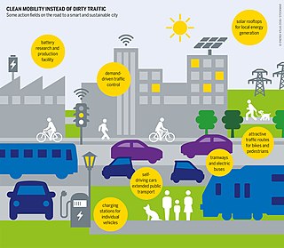
A smart city is a technologically modern urban area that uses different types of electronic methods and sensors to collect specific data. Information gained from that data is used to manage assets, resources and services efficiently; in return, that data is used to improve operations across the city. This includes data collected from citizens, devices, buildings and assets that is processed and analyzed to monitor and manage traffic and transportation systems, power plants, utilities, urban forestry, water supply networks, waste, criminal investigations, information systems, schools, libraries, hospitals, and other community services. Smart cities are defined as smart both in the ways in which their governments harness technology as well as in how they monitor, analyze, plan, and govern the city. In smart cities, the sharing of data is not limited to the city itself but also includes businesses, citizens and other third parties that can benefit from various uses of that data. Sharing data from different systems and sectors creates opportunities for increased understanding and economic benefits.
Michael T. Voorhees is an American entrepreneur, engineer, designer, geographer, and aeronaut focusing on the need for sustainability in technology, business, and societal choices. He is the founding CEO of Skylite Aeronautics and Chief Designer of the Skylite 500 GeoShip, a modern rigid airship being developed for passenger, cargo, and humanitarian transportation purposes.

The Geoscope was a proposal by Buckminster Fuller around 1960 to create a 200-foot-diameter (61 m) globe that would be covered in colored lights so that it could function as a large spherical display. It was envisioned that the Geoscope would be connected to computers which would allow it to display both historical and current data, and enable people to visualize large scale patterns around the world. Several projects by his students to build a "miniature Earth", starting with a 20-foot version at Cornell University in 1952, were precursors of the Geoscope proposal. Before proposing the Geoscope, Fuller had invented the Dymaxion map, a novel map projection for the whole Earth.
The Buckminster Fuller Challenge is an annual international design competition that awards $100,000 to the most comprehensive solution to a pressing global problem. The Challenge was launched in 2007 and is a program of The Buckminster Fuller Institute. The competition, open to designers, artists, architects, students, environmentalists, and organizations world-wide, has been dubbed "Socially-Responsible Design's Highest Award" by Metropolis Magazine.
The Stockade Building System was designed by Richard Buckminster Fuller and his father-in-law, James Monroe Hewlett, and was patented in 1927. Both of them had previously formed a company, in 1922, which made bricks out of compressed wood shavings with vertical holes cast in them.

Open Source Ecology (OSE) is a network of farmers, engineers, architects and supporters, whose main goal is the eventual manufacturing of the Global Village Construction Set (GVCS). As described by Open Source Ecology "the GVCS is an open technological platform that allows for the easy fabrication of the 50 types of industrial machines that it takes to build a small civilization with modern comforts". Groups in Oberlin, Ohio, Pennsylvania, New York and California are developing blueprints, and building prototypes in order to test them on the Factor e Farm in rural Missouri. 3D-Print.com reports that OSE has been experimenting with RepRap 3-D printers, as suggested by academics for sustainable development.

Urban planning, also known as town planning, city planning, regional planning, or rural planning in specific contexts, is a technical and political process that is focused on the development and design of land use and the built environment, including air, water, and the infrastructure passing into and out of urban areas, such as transportation, communications, and distribution networks, and their accessibility. Traditionally, urban planning followed a top-down approach in master planning the physical layout of human settlements. The primary concern was the public welfare, which included considerations of efficiency, sanitation, protection and use of the environment, as well as effects of the master plans on the social and economic activities. Over time, urban planning has adopted a focus on the social and environmental bottom lines that focus on planning as a tool to improve the health and well-being of people, maintaining sustainability standards. Similarly, in the early 21st century, Jane Jacobs's writings on legal and political perspectives to emphasize the interests of residents, businesses and communities effectively influenced urban planners to take into broader consideration of resident experiences and needs while planning.
References
- ↑ Buckminster Fuller Institute. "Design Science". BFI.org. Archived from the original on 6 October 2013. Retrieved 15 March 2016.
- ↑ Mooc-List. "FC-01x Future Cities". Mooc-List. Retrieved 15 March 2016.