Clara Town

Last updated

Clara Town located on a map of greater Monrovia. Shantytown map Monrovia (cropped).jpg
Clara Town located on a map of greater Monrovia.
Clara Town is across the bridge on Bushrod Island. To the left of the photo is the slum of West Point. Slums Monrovia Liberia West Africa July 2013.jpg
Clara Town is across the bridge on Bushrod Island. To the left of the photo is the slum of West Point.

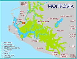
Clara Town is a slum located on Bushrod Island in Monrovia, the capital of Liberia. [1] [2] It is built upon a swamp. [2] Clara Town was one of several ethnic communes that was squatted in the outskirts of Monrovia. [3] Clara Town had around 4,500 inhabitants in 1964 out of whom 99% were Kru. [4]

An area within Clara Town is named "Struggle Community". [2] According to The New Humanitarian this zone is "a network of haphazard, rubbish-strewn streets, many of which are flooded for several months of the year". [2] In this area, 10,000 residents share two privately owned water taps. [2] Clara Town's 75,000 people shared 11 public toilets and 22 public taps in 2009. [2]

Notable people

Related Research Articles

<span class="mw-page-title-main">Liberia</span> Country in West Africa

Liberia, officially the Republic of Liberia, is a country on the West African coast. It is bordered by Sierra Leone to its northwest, Guinea to its north, Ivory Coast to its east, and the Atlantic Ocean to its south and southwest. It has a population of around 5 million and covers an area of 43,000 square miles (111,369 km2). English is the official language, but over 20 indigenous languages are spoken, reflecting the country's ethnic and cultural diversity. The country's capital and largest city is Monrovia.

<span class="mw-page-title-main">Monrovia</span> Capital, chief port, and the largest city of Liberia

Monrovia is the capital city of the West African country of Liberia. Founded in 1822, it is located on Cape Mesurado on the Atlantic coast, and is the country's most populous city. As of the 2008 census, with 1,010,970 residents, it was home to 29% of Liberia’s total population. Monrovia is also the country’s economic, financial and cultural center. Its economy is primarily centered on its harbor and its role as the seat of Liberia's government.

<span class="mw-page-title-main">Montserrado County</span> County in Liberia

Montserrado County is a county in the northwestern portion of the West African nation of Liberia containing its national capital, Monrovia. One of 15 counties that comprise the first-level of administrative division in the nation, it has 17 sub political districts. As of the 2008 Census, it had a population of 1,118,241, making it the most populous county in Liberia. The area of the county measures 1,912.7 square kilometres (738.5 sq mi), the smallest in the country. Bensonville serves as the capital.

<span class="mw-page-title-main">George Weah</span> President of Liberia since 2018, former footballer

George Tawlon Manneh Oppong Ousman Weah is a Liberian politician and former professional footballer who is serving as the president of Liberia, in office since 2018. Prior to his election to the presidency, Weah served as Senator from Montserrado County. He played as a striker in his prolific 18-year professional football career, which ended in 2003. He is the first African former professional footballer to become a head of state.

<span class="mw-page-title-main">Kru people</span> Ethnic group in West Africa

The Kru, Kroo, Krou or Kuru are a West African ethnic group who are indigenous to western Ivory Coast and eastern Liberia. They migrated and settled along various points of the West African coast, notably Freetown, Sierra Leone, but also the Ivorian and Nigerian coasts. The Kru people are a large ethnic group that is made up of several sub-ethnic groups in Liberia and Ivory Coast. These tribes include Bété, Bassa, Krumen, Guéré, Grebo, Klao, Krahn people and, Jabo people. The kru people were more valuable as traders and sailors on slave ships than as slave labor. To ensure their status as “freemen,” they initiated the practice of tattooing their foreheads and the bridge of their nose with indigo dye to distinguish them from slave labor.

<span class="mw-page-title-main">2005 Liberian general election</span> General election held in Liberia

General elections were held in Liberia on 11 October 2005, with a runoff election for the presidency held on 8 November. The presidency and all seats in the House of Representatives and Senate were up for election. The elections were the first held since 1997 and marked the end of the political transition following the second civil war, having been stipulated in the Accra Comprehensive Peace Agreement of 2004. Ellen Johnson Sirleaf, former World Bank employee and Liberian finance minister, won the presidential contest and became the first democratically elected female African head of state in January 2006.

<span class="mw-page-title-main">Paynesville, Liberia</span> Place in Montserrado County, Liberia

Paynesville is a suburb east of Monrovia, Liberia. It is geographically larger than the city of Monrovia and is expanding eastward along the Robertsfield Highway and northeastward beyond Red Light Market, one of the largest market areas in Liberia. Paynesville is often considered a part of the Greater Monrovia area. It was the location of the Paynesville Omega Transmitter, the highest structure of Africa, until the tower's demolition in 2011. The Liberia Broadcasting System is also located in Paynesville. The Liberian Judo Federation is based in Paynesville.

<span class="mw-page-title-main">Unity Party (Liberia)</span> Political party in Liberia

The Unity Party (UP) is a political party in Liberia that was started in 1984 by Edward B. Kesselly, also its first standard bearer. Officially founded at Buchanan in Grand Bassa County, the party was established on 27 July 1985. The Unity Party participated in the first elections after the 1980 coup, running against President Samuel Doe in October 1985. The party has remained active in Liberian politics since and was, until 2017, the ruling party.

<span class="mw-page-title-main">Joseph Boakai</span> Liberian politician

Joseph Nyumah Boakai is a Liberian politician who served as the 29th vice president of Liberia from 2006 to 2018, serving under President Ellen Johnson Sirleaf. Previously, he served as Minister of Agriculture from 1983 to 1985.

Greater Monrovia is one of four districts located in Montserrado County, Liberia. It contains the country's capital Monrovia. It recorded a population of 970,824 in the 2008 census.

<span class="mw-page-title-main">Invincible Eleven</span> Liberian football club

Union of Invincible Eleven & Majestic Sports Association Inc., also known as Invincible Eleven (I.E.), is a Liberian football club based in Monrovia. They are Liberia's oldest club. Their home stadium is the Antonette Tubman Stadium. I.E. is one of Liberia's most popular and historic clubs, along with Mighty Barolle. George Weah, Liberia's most famous footballer and current president, scored 24 goals in 23 games during a spell at I.E. in the 1986/87 season.

A new civil war began in 1999 when a rebel group backed by the government of neighboring Guinea, the Liberians United for Reconciliation and Democracy (LURD), emerged in northern Liberia. By the spring of 2001, they were posing a major threat to the Taylor government. Liberia was now engaged in a complex three-way conflict with Sierra Leone and the Guinea Republic. By the beginning of 2002, both of these countries were supporting the latest addition to the lexicon of Liberian guerrilla outfits – Liberians United for Reconciliation and Democracy (LURD), while Taylor was supporting various opposition factions in both countries. By supporting Sierra Leonean rebels, Taylor also drew the enmity of the British and Americans.

<span class="mw-page-title-main">West Point, Monrovia</span> Township in Montserrado, Liberia

West Point is a township of the Liberian capital city of Monrovia, located on a 0.53 km2 peninsula which juts out into the Atlantic Ocean between the Mesurado and Saint Paul rivers. West Point is one of Monrovia's most densely populated slums.

<span class="mw-page-title-main">New Georgia, Liberia</span>

New Georgia is a township in Montserrado County, Liberia that was first settled by Africans who had been taken from slave ships seized or wrecked near the United States and then sent to Liberia after several years had passed.

New Kru Town is a northwestern coastal suburb of Monrovia, Liberia.

<span class="mw-page-title-main">Ebola virus epidemic in Liberia</span> Health disaster in Africa

An epidemic of Ebola virus disease occurred in Liberia from 2014 to 2015, along with the neighbouring countries of Guinea and Sierra Leone. The first cases of virus were reported by late March 2014. The Ebola virus, a biosafety level four pathogen, is an RNA virus discovered in 1976.

<span class="mw-page-title-main">Environmental issues in Liberia</span>

Environmental issues in Liberia include the deforestation of tropical rainforest, the hunting of endangered species for bushmeat, the pollution of rivers and coastal waters from industrial run-off and raw sewage, and the burning and dumping of household waste.

The following is a timeline of the history of the city of Monrovia, Liberia.

<span class="mw-page-title-main">Gbehzohngar Milton Findley</span> Liberian politician and businessman

Gbehzohngar Milton Findley is a Liberian politician and businessman. He is a former President Pro Tempore of the Liberian Senate and also the Minister of Foreign Affairs in the administration of President Weah until 28th July 2020.

<span class="mw-page-title-main">Garworlohn Township</span>

The Garworlohn Township is a township of the Greater Monrovia District, Montserrado County, Liberia. It is located on Bushrod Island, and stretches from Vai Town in the south to Bong Mines Bridge in the north. Politically, Garworlohn Township is divided between the Montserrado-13, Montserrado-14 and Montserrado-15 electoral districts.

References

  1. "Maps of Major Streets in Monrovia". Archived from the original on 16 May 2008. Retrieved 8 December 2008.{{cite web}}: CS1 maint: unfit URL (link)
  2. 1 2 3 4 5 6 "LIBERIA: Disease rife as more people squeeze into fewer toilets", IRIN News, 19 November 2009.
  3. Robert A. Obudho; Constance C. Mhlanga (1988). Slum and Squatter Settlements in Sub-Saharan Africa: Toward a Planning Strategy. Praeger. p. 45. ISBN   978-0-275-92309-9.
  4. Willi Schulze (1973). Liberia: länderkundl. Dominanten u. regionale Strukturen. Wissenschaftliche Buchgesellschaft. p. 131. ISBN   978-3-534-05821-1.
  5. Talk Football, "Liberian Football Legend Profile: George Weah"

Coordinates: 6°20′N10°48′W / 6.333°N 10.800°W / 6.333; -10.800