Related Research Articles
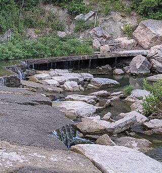
Pillsbury Crossing is a natural limestone slab that was used by pioneers to cross Deep Creek. The ledge terminates in a waterfall in Riley County, Kansas, USA. The waterfall is about 40 feet (12 m) wide and has a drop of around 5 feet (1.5 m). Below Pillsbury Crossing, Deep Creek flows into the Kansas River.

Perry Lake is a US Army Corps of Engineers operated reservoir in northeast Kansas. Its primary purposes are flood control, water reserve for nearby areas and regional recreation. The lake is approximately 11,150 acres (45 km2) in size, with over 160 miles (260 km) of shoreline. Perry Lake's full multi-purpose pool elevation is 891.5 feet (271.7 m) above sea level. Perry Lake is located about 40 miles (64 km) west of Kansas City, just northwest of Lawrence, Kansas. Its close proximity to Kansas City, Lawrence, and the state capitol, Topeka, make it a very popular destination, with the nickname "Paradise on the Plains".
Mooney Creek is an unincorporated community in northeastern Jefferson County, Kansas, United States. It is named for Mooney Creek, a right-hand tributary of Big Stranger Creek.

Missouri's 6th congressional district takes in a large swath of land in northern Missouri, stretching across nearly the entire width of the state from Kansas to Illinois. Its largest voting population is centered in the northern portion of the Kansas City metropolitan area and the town of St. Joseph. The district includes much of Kansas City north of the Missouri River.
Mission Creek is a water body west of Topeka, Kansas, United States. The 30-mile-long (48 km) tributary of the Kansas River goes through Wabaunsee County and Shawnee County, Kansas. Mission Creek was named for a Kaw mission near the banks.

Diamond Creek Township is a township in Chase County, Kansas, United States. As of the 2000 census, its population was 237.

Lecompton Township is a township in Douglas County, Kansas, USA. As of the 2000 census, its population was 1,761.

Wakarusa Township is a township in Douglas County, Kansas, United States. As of the 2010 census, its population was 2,318. It was named for the Wakarusa River which flows through Douglas County from Wabaunsee County to the Kansas River near Eudora.
Wildcat Creek is a creek in Riley County, Kansas, which occasionally floods.

Lovewell Reservoir is a reservoir in Jewell County, Kansas, United States. Built and managed by the U.S. Bureau of Reclamation, it is used for flood control, irrigation, and recreation. Lovewell State Park is located on its north shore.
Rose Creek Township is a township in Republic County, Kansas, United States.
Halfday Creek is a stream in Jackson County, Kansas and Shawnee County, Kansas, in the United States.
Soldier Creek is a stream in Jackson County, Kansas and Shawnee County, Kansas and Nemaha County, Kansas, in the United States. It is a tributary of the Kansas River.
Munkers Creek is a 15-mile (24 km) long stream in Morris County, Kansas and Wabaunsee County, Kansas, in the United States. It ends at Council Grove Reservoir.
Elm Creek is a stream in Morris County, Kansas, in the United States. It is a tributary of the Neosho River.
Lairds Creek is a stream in Morris County, Kansas, in the United States.
Slough Creek is a stream in Morris County, Kansas, in the United States. It flows to Council Grove Lake.
Gilmore Creek is a stream in Morris County, Kansas, in the United States.
Lyon Creek is a stream in Geary, Dickinson and Marion counties, Kansas, in the United States.
Moss Creek Township is a township in Carroll County, in the U.S. state of Missouri. Moss Creek Township has a population of 96 according to the 2020 census.
References
39°05′20″N96°42′41″W / 39.088887°N 96.711395°W
| | This article about a location in Geary County, Kansas is a stub. You can help Wikipedia by expanding it. |
| | This article about a location in Morris County, Kansas is a stub. You can help Wikipedia by expanding it. |