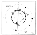
Clava cairns of Aviemore

Last updated

There are three Clava cairns in or near the Scottish Highland town of Aviemore. All three were described by Caleb George Cash, an honorary fellow of the Royal Scottish Geographical Society, in 1906.

Contents

Delfour stone circle

The stone circle is 4 miles SW of Aviemore railway station, and 2 miles NNE of Kincraig railway station, and in 1906 was located near a cottage. Its condition, as described by Cash in 1906, is ruinous; it could hardly be recognized as anything other than "a heap of stones cleared by the farmer from his fields". One stone of "striking appearance" is still standing. The middle circle of ca. 60 feet in diameter seems to have been used for the purpose of field clearing, with stones from the outer circles having been deposited there. The one solitary stone from what may have been an outer circle stands about 22 feet SW from the middle circle; it is a quartzite slab, 9'6" high, 5'6" wide, and 1'6" thick. Since it's tapered toward the top, it appears to Cash as a "cloaked human figure". [1]

There is an outer kerb (58 ft in diameter) and an inner ring, made of smaller stones. There was a bank of small stones just outside the kerb, which was part of the design; stones from the field have been thrown onto that bank. [2]

Aviemore stone circle

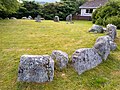
The cairn consists of three stone circles, or remnants thereof. The outer one, of detached megaliths, is ca. 75 ft in diameter. [1] The second circle is of graded kerbstone sets closely, [3] with a diameter of ca. 42 feet, and the inner circle is ca. 26 feet. [1] The cairn is mostly gone and only three or four slabs are left. [3]

In 1877 there were still seven stones standing in the centre; when Aubrey Burl detailed the cairn in 2005, there were only five left, one of which has fallen. The tallest is 1.5 m high.The cairn is currently in the middle of a housing estate. [3]

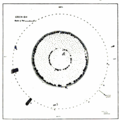
Grenish stone circle

The Grenish circle is a little over 2 miles E.N.E. of the Aviemore railway station, some 350 yards east of the road, in an area of uneven moorland [1] that was once covered in pine trees. [4] A nearby lochan gets its name from the stones: Loch nan Carraigean, or "Loch of the Standing Stones". The Highland Railway's line to Carr Bridge runs nearby (now the preserved Strathspey Railway), only a few yards from the outer circle on the west side; equally close on the east side runs an old path from Aviemore to Boat of Garten. [1]

See also

Related Research Articles

<span class="mw-page-title-main">Stones of Stenness</span> Henge in Orkney Islands, Scotland, UK

The Standing Stones of Stenness is a Neolithic monument five miles northeast of Stromness on the mainland of Orkney, Scotland. This may be the oldest henge site in the British Isles. Various traditions associated with the stones survived into the modern era and they form part of the Heart of Neolithic Orkney World Heritage Site. They are looked after by Historic Environment Scotland as a scheduled monument.

<span class="mw-page-title-main">Steinacleit</span> Prehistoric archaeological site

Steinacleit is a prehistoric archeological site on the west coast of Lewis in the Outer Hebrides of Scotland.

<span class="mw-page-title-main">Callanish II</span>

The Callanish II stone circle is one of many megalithic structures around the better-known Calanais I on the west coast of the Isle of Lewis, in the Outer Hebrides, Scotland.

<span class="mw-page-title-main">Doll Tor</span> Bronze age stone circle in Derbyshire

Doll Tor is a stone circle located just to the west of Stanton Moor, near the village of Birchover, Derbyshire in the English East Midlands. Doll Tor is part of a tradition of stone circle construction that spread throughout much of Britain, Ireland, and Brittany during the Late Neolithic and Early Bronze Ages, over a period between 3300 and 900 BCE. The purpose of such monuments is unknown, although archaeologists speculate that the stones represented supernatural entities for the circles' builders.

<span class="mw-page-title-main">Avielochan</span> Hamlet in Highland, Scotland

Avielochan is a hamlet in the historical county of Inverness-shire, within the Highland council area of Scotland. It is located north of Aviemore, on the A9 road. The area is noted for its prehistoric cairn.

Machrie Moor Stone Circles

Machrie Moor Stone Circles is the collective name for six stone circles visible on Machrie Moor near the settlement of Machrie on the Isle of Arran, Scotland.

Goodaver, Goodaver stone circle or Goodaver circle is a stone circle located in the parish of Altarnun, near Bolventor on Bodmin Moor in Cornwall, UK.

<span class="mw-page-title-main">Stripple stones</span> Henge and stone circle in Cornwall, England

The Stripple stones is a henge and stone circle located on the south slope of Hawk's Tor, Blisland, 10 kilometres (6.2 mi) north northeast of Bodmin on Bodmin Moor in Cornwall, England, UK.

<span class="mw-page-title-main">Stone circles in the British Isles and Brittany</span> Megalithic tradition of monuments

The stone circles in the British Isles and Brittany are a megalithic tradition of monuments consisting of standing stones arranged in rings. These were constructed from 3300 to 900 BCE in Britain, Ireland and Brittany. It has been estimated that around 4,000 of these monuments were originally constructed in this part of north-western Europe during this period. Around 1,300 of them are recorded, the others having been destroyed.

Moss Farm Road Stone Circle

Moss Farm Road Stone Circle is the remains of a Bronze Age burial cairn, surrounded by a circle of stones. It is located near Machrie on the Isle of Arran in Scotland.

Cullerlie stone circle Stone circle in Aberdeenshire, Scotland

Cullerlie stone circle, also known as the Standing Stones of Echt, is a small stone circle situated near Echt, Aberdeenshire. It consists of eight irregular stones of red granite arranged at approximately equal intervals to form a circle of 10.2 m (33 ft) diameter, enclosing the same number of small cairns. The cairns are characterised by outer kerbs or rings of stones, with a double ring surrounding the central cairn and a single ring in the others. All but one of the cairns have eleven ringstones, with the last having nine. The whole circle sits on a patch of gravel which forms the end of a low gravel ridge linking the site with Leuchar Moss. It is regarded as "a later development from the recumbent stone circle", though its layout with kerbed cairns within the circle makes it unique.

Rosdoagh Stone Circle is a court cairn and National Monument located in County Mayo, Ireland.

<span class="mw-page-title-main">Porlock Stone Circle</span> Neolithic stone circle in Somerset, England

Porlock Stone Circle is a stone circle located on Exmoor, near the village of Porlock in the south-western English county of Somerset. The Porlock ring is part of a tradition of stone circle construction that spread throughout much of Britain, Ireland, and Brittany during the Late Neolithic and Early Bronze Age, over a period between 3300 and 900 BCE. The purpose of such monuments is unknown, although archaeologists speculate that the stones represented supernatural entities for the circles' builders.

<span class="mw-page-title-main">Withypool Stone Circle</span> Late neolithic stone circle in Somerset, England

Withypool Stone Circle, also known as Withypool Hill Stone Circle, is a stone circle located on the Exmoor moorland, near the village of Withypool in the southwestern English county of Somerset. The ring is part of a tradition of stone circle construction that spread throughout much of Britain, Ireland, and Brittany during the Late Neolithic and Early Bronze Age, over a period between 3300 and 900 BCE. The purpose of such monuments is unknown, although archaeologists speculate that the stones represented supernatural entities for the circle's builders.

<span class="mw-page-title-main">Axial stone circle</span> Type of megalithic monument in counties Cork and Kerry, Ireland

An axial stone circle is a megalithic ring of stones of a particular design found in County Cork and County Kerry in southwest Ireland. Archaeologists have found it convenient to consider the axial five-stone circle and axial multiple-stone circle separately. The circle has an approximate axis of symmetry aligned in a generally northeast–southwest direction. The stone at the southwest side of the circle, rather than being an upright orthostat like all the rest, is a slab lying horizontally with its long thin edge along the circumference of the ring. Because it marks the axis of the circle it is called the axial stone.

<span class="mw-page-title-main">Kealkill stone circle</span> Axial five-stone stone circle in County Cork, Ireland

Kealkill stone circle is a bronze age axial five-stone circle located just outside the village of Kealkill, County Cork in southwest Ireland. When it was excavated in 1938 it was thought the crucial axial stone indicated an alignment to the north, contrary to the general alignment of such stone circles to the southwest. However, later archaeologists have thought it is the comparatively insignificant stone to the southwest that is the axial stone. There are two associated standing stones nearby, one of which had fallen and was re-erected in 1938.

<span class="mw-page-title-main">Tomnaverie stone circle</span> Recumbent stone circle in Aberdeenshire

Tomnaverie stone circle is a recumbent stone circle set on the top of a small hill in lowland northeast Scotland. Construction started from about 2500 BC, in the Bronze Age, to produce a monument of thirteen granite stones including a massive 6.5-ton recumbent stone lying on its side along the southwest of the circle's perimeter. Within the 17-metre (56 ft) circle are kerb stones encircling a low 15-metre (49 ft) ring cairn but the cairn itself no longer exists.

<span class="mw-page-title-main">Loanhead of Daviot stone circle</span> Recumbent stone circle in Aberdeenshire

Loanhead of Daviot stone circle is a recumbent stone circle in Aberdeenshire in lowland northeast Scotland. The circle consists of the recumbent stone with its flankers and a complete set of eight orthostats about 21 metres (69 ft) in diameter surrounding a low kerbed ring cairn which has an open court. However, the present appearance has in part been produced by substantial restoration after archaeological excavation in 1934, and in 1989 by the removal of the stones covering the central court.

<span class="mw-page-title-main">Tyrebagger stone circle</span> Stone circle in Aberdeen, Scotland

Tyrebagger stone circle is located at Dyce, near to Aberdeen in Scotland. It is a complete recumbent stone circle. It was used as a cattle pound in the past and now stands close to the Aberdeen Western Peripheral Route. It is a scheduled monument since 1925.

References

  1. 1 2 3 4 5 Cash, Caleb George (1906). "Stone Circles near Aviemore". The Cairngorm Club Journal. 5 (27): 151–63.
  2. "Delfour". Canmore . Retrieved 9 April 2022.
  3. 1 2 3 Burl, Aubrey (2005). A Guide to the Stone Circles of Britain, Ireland and Brittany. Yale UP. ISBN   9780300114065.
  4. On the history of forestation in the Spey Valley, see Fenton, E. Wyllie (1935). "The Transition From Woodland and Moorland to Grassland in the Spey Valley and Elsewhere". Journal of Ecology . 23 (1): 56–68.

Coordinates: 57°11′56″N3°49′39″W / 57.198767°N 3.827386°W / 57.198767; -3.827386