Related Research Articles

The St. Joseph River is an 86.1-mile-long (138.6 km) tributary of the Maumee River in northwestern Ohio and northeastern Indiana in the United States, with headwater tributaries rising in southern Michigan. It drains a primarily rural farming region in the watershed of Lake Erie.

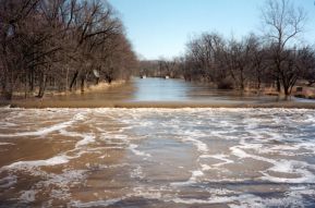
Cedar Creek is the largest tributary of the St. Joseph River, draining 174,780 acres (707.3 km2) in the Eastern Corn Belt Plains of northeastern Indiana. It is 31.9 miles (51.3 km) long, rising in northwestern DeKalb County and joining the St. Joseph just below the Cedarville Dam in Allen County.
The Eel River is a 94-mile-long (151 km) tributary of the Wabash River in northern Indiana in the United States. Via the Wabash and Ohio rivers, its waters flow to the Mississippi River and ultimately the Gulf of Mexico. The Eel River rises southeast of Huntertown in Allen County and flows southwest through Allen, Whitley, Kosciusko, Wabash, Miami, and Cass counties to join the Wabash at Logansport. The river was called Kineepikwameekwa Siipiiwi - "river of the snake fish" by the Miami people, who inhabited the area at the time of European contact, the English rendered it as Ke-na-po-co-mo-co. It is the northern of the two rivers named Eel River within Indiana.

Clear Creek is a tributary of the upper Sacramento River in northern California.
Cedar Creek Canyon, also called simply Cedar Canyon, is a topographical feature located in Allen County, Indiana, United States. It is a very straight, narrow gorge about 50 to 100 feet deep that contains part of the lower segment of Cedar Creek, the largest tributary of the St. Joseph River. The canyon originated at the end of the last ice age as a tunnel valley, a channel under the Erie Lobe of the Wisconsin Glacier that discharged meltwater under considerable pressure into the ancestral Eel River, a tributary of the Wabash River. Cutting through the north limb of the Wabash Moraine, a debris deposit left by the retreating ice, the discharge left a large outwash fan that blocked the Eel, diverting its upper portion into the canyon in a classic example of stream piracy that formed today's Cedar Creek. This was part of a general drainage reversal that occurred in northeastern Indiana as the Maumee River opened and captured drainage that was previously part of the watershed of the Wabash. While the lower Eel remained a tributary of the Wabash, 175,000 acres (710 km2) that it formerly drained became part of the Maumee watershed.
Skippack Creek is a 15.7-mile-long (25.3 km) tributary of Perkiomen Creek in Montgomery County, Pennsylvania in the United States. Skippack Creek joins Perkiomen Creek approximately 3 miles (5 km) upstream of that creek's confluence with the Schuylkill River.

Chester Township is one of seven townships in Wabash County, Indiana, United States. As of the 2020 census, its population was 7,001 and it contained 3,115 housing units.

Cleveland Township is one of nine townships in Whitley County, Indiana, United States. As of the 2020 census, its population was 3,324 and it contained 1,398 housing units.
The East Branch South Fork Eel River, a tributary of the South Fork Eel River, is formed by the confluence of Cruso Cabin Creek and Elkhorn Creek, in Mendocino County in the U.S. state of California. The river is roughly 25 miles (40 km) long, meandering west to its confluence with the South Fork Eel at Benbow State Recreation Area. Major tributaries of the East Branch include Buck Mountain Creek, Squaw Creek, Rays Creek, and Tom Long Creek. The river flows west, turns north, and flows west again, through rugged terrain in the Coast Range of California. The East Branch is the South Fork Eel's largest tributary.

Stony Brook Branch is a tributary of the Stony Brook in Mercer County, New Jersey in the United States.
The Eel River is a 52.8-mile-long (85.0 km) tributary of the White River in southwestern Indiana. Via the White, Wabash, and Ohio rivers, its waters flow to the Mississippi River and the Gulf of Mexico. The Eel River flows through Greene, Owen, Clay, and Putnam counties. It is the southern of the two rivers named Eel River within Indiana.
Brandywine Creek is a stream in Shelby, Hancock and Franklin counties, Indiana, in the United States. It is a tributary of Big Blue River.
Pipe Creek is a stream in the U.S. state of Indiana. It is a tributary of the White River, and is named for Captain Pipe, a Delaware chief.
Jordan Creek is a stream in Clay and Owen counties, in the U.S. state of Indiana. It is a tributary of the Eel River.
Duncan Creek is a stream in Bates and Vernon counties in the U.S. state of Missouri. It is a tributary of the Little Osage River. The stream headwaters arise at 38°4′55″N94°34′58″W south of the community of Hume in Bates County and one mile from the Missouri-Kansas border. It flows to the south into Vernon County and passes just west of the community of Amos and on to its confluence with the Little Osage two miles northwest of Stotesbury at 37°59′48″N94°35′3″W.
Beargrass Creek is a stream in the U.S. state of Indiana. It is a tributary of the Eel River.
Silver Creek is a stream in the U.S. state of Indiana. It is a tributary of the Eel River.
Wheeler Creek is a stream in the U.S. state of Indiana. It is a tributary of Eel River.
Brooks Creek is a stream in the U.S. state of Indiana. It is a tributary to the Salamonie River.
References
- ↑ U.S. Geological Survey Geographic Names Information System: Clear Creek (Eel River tributary)
- ↑ Dept. of English and Journalism (1973). Indiana names, v.4. Indiana State University. p. 11.
40°59′48″N85°48′38″W / 40.99667°N 85.81056°W
| | This article related to a river in Indiana is a stub. You can help Wikipedia by expanding it. |