Related Research Articles

Clay County is a county located in the U.S. state of Kentucky. As of the 2020 census, the county population was 20,345. Clay County Kentucky is part of the Corbin Kentucky Micropolitan statistical area. Its county seat is Manchester. The county was formed in 1807 and named in honor of Green Clay (1757–1826). Clay was a member of the Virginia and Kentucky State legislatures, first cousin once removed of Henry Clay, U.S. Senator from Kentucky and Secretary of State in the 19th century.

Pineville is a home rule-class city in Bell County, Kentucky, United States. It is the seat of its county. The population was 1,732 as of the 2010 census. It is located on a small strip of land between the Cumberland River and Pine Mountain.

South Wallins is an unincorporated community and census-designated place (CDP) in Harlan County, Kentucky, United States. The population was 859 at the 2010 census, down from 996 at the 2000 census.

The Big South Fork of the Cumberland River is a 76-mile-long (122 km) river in the U.S. states of Tennessee and Kentucky. It is a major drainage feature of the Cumberland Plateau, a major tributary of the Cumberland River system, and the major feature of the Big South Fork National River and Recreation Area.

The Sheltowee Trace Trail is a 343-mile (552.00 km) National Recreation Trail that was created in 1979 and stretches from the Burnt Mill Bridge Trail Head in the Big South Fork National River and Recreation Area in Tennessee to northern Rowan County, Kentucky. The trail is named after Daniel Boone, who was given the name Sheltowee when he was adopted as the son of the great warrior Chief Blackfish of the Shawnee tribe.
The Red Bird River is one of two tributaries at the head of the South Fork Kentucky River, the other being the Goose Creek. It is located in the Daniel Boone National Forest, in the southeast of the U.S. state of Kentucky. It is 34.3 miles (55.2 km) long and drains the eastern half of Clay County.
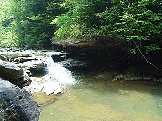
The Clear Fork is a 42.8-mile-long (68.9 km) tributary of the Cumberland River in Kentucky and Tennessee. By the Cumberland and Ohio rivers, it is part of the Mississippi River watershed.
Williba is an unincorporated community in Lee County, Kentucky, United States, located on Fraley Creek, one-half mile from the confluence of the North Fork and the Kentucky River.

Lotts Creek is a creek in Perry County and Knott County, Kentucky in the United States. It is a tributary of the North Fork Kentucky River that joins it at Darfork 3 miles (4.8 km) downstream of Hazard at an altitude of 820 feet (250 m). It is 8.5 miles (13.7 km) long from its mouth to where it splits into the Young's and Kelly Forks.
Fourmile is an unincorporated community located in Bell County, Kentucky.
Horse Creek is a creek a tributary of Goose Creek river in Clay County, Kentucky. It is 1.5 miles (2.4 km) upstream of Manchester on Goose at an altitude of 800 feet (240 m).
Trace Fork or Trace Branch is a creek in Perry County, Kentucky in the United States. It a fork of Lotts Creek 1 mile (1.6 km) upstream from the latter's mouth at an altitude of 825 feet (251 m).

The Poor Fork is a 45-mile (72 km) tributary of the Cumberland River in Letcher and Harlan Counties, southeast Kentucky, in the United States. The river flows from its source at Flat Gap in Letcher County, on the Kentucky–Virginia border, generally southwest to where it meets Martin's Fork in Baxter to form the Cumberland River.
Stinking Creek is a stream in Knox County, Kentucky, in the United States.
Cassidy Creek is a stream in Fleming County, Kentucky, in the United States. It is a tributary of the Licking River.
Clear Creek Springs is an unincorporated community in Bell County, Kentucky, United States. It is named after Clear Creek.
Salt Lick Creek is a stream in Lewis County, Kentucky, in the United States. It is a tributary of the Ohio River.
Lawrence Creek is a stream in Mason County, Kentucky, in the United States. It is a tributary of the Ohio River.
Drakes Creek is a stream in Warren County, Kentucky, in the United States. It is a tributary of the Barren River. Drakes Creek, as measured at Alvaton, has a mean annual discharge of 768 cubic feet per second. Drakes Creek was named for a white pioneer named Drake who narrowly escaped with his life an attack by Indians. The Shaker community of South Union, Kentucky, attempted a settlement along the creek, some 16 miles from their main village, in 1817, but the effort was abandoned in 1829.
Collins Creek, also known as Collins Fork, is a creek that is a fork of Goose Creek in Knox County and Clay County, Kentucky. It is 19 miles (31 km) long; is named for its first settler James Collins, a salt maker and hunter; joins Goose just south of Garrard; and is paralleled by road and railway for most of its course.
References
- ↑ U.S. Geological Survey Geographic Names Information System: Clear Creek (Kentucky)
- ↑ Collins, Lewis (1877). History of Kentucky. p. 412.
36°44′45″N83°41′25″W / 36.7459187°N 83.6901952°W
| | This Bell County, Kentucky state location article is a stub. You can help Wikipedia by expanding it. |