
Clearfield County is a sixth-class county located in the U.S. state of Pennsylvania. As of the 2010 census, the population was 81,642. The county seat is Clearfield, and the largest city is DuBois. The county was created in 1804 and later organized in 1822.

Cambria County is a county located in the U.S. state of Pennsylvania. As of the 2010 census, the population was 143,679. Its county seat is Ebensburg. The county was created on March 26, 1804, from parts of Bedford, Huntingdon, and Somerset Counties and later organized in 1807. It was named for the nation of Wales, which in Latin is known as "Cambria".

Clearfield Township is a township in Cambria County, Pennsylvania, United States. The population was 1,604 at the 2010 census. It is part of the Johnstown, Pennsylvania Metropolitan Statistical Area.
Covington Township is a township in Clearfield County, Pennsylvania, United States. The population was 526 at the 2010 census.

Girard Township is a township in Clearfield County, Pennsylvania, United States. The population was 534 at the 2010 census.

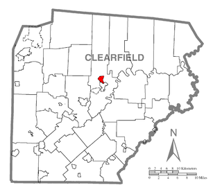
Hyde is an unincorporated community and census-designated place (CDP) in Clearfield County, Pennsylvania, United States. The population was 1,399 at the 2010 census.
Irvona is a borough in Clearfield County, Pennsylvania, United States. The population was 647 at the 2010 census.

Karthaus Township is a township in Clearfield County, Pennsylvania, United States. The population was 811 at the 2010 census.

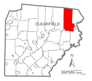
Lawrence Township is a township in Clearfield County, Pennsylvania, United States. The population was 7,681 at the 2010 census. Lawrence Township borders the townships of Boggs, Bradford, Goshen, Huston, Knox, Pike and Pine in Clearfield County, as well as Benezette and Jay Townships in Elk County to the north. Lawrence Township borders the borough of Clearfield as well.

Mahaffey is a borough in Clearfield County, Pennsylvania, United States. The population was 368 at the 2010 census.

Pine Township is a township in Clearfield County, Pennsylvania, United States. The population was 60 at the 2010 census. S. B. Elliott State Park a Pennsylvania state park is in Pine Township. Many of the structures at the park were built by the Civilian Conservation Corps during the Great Depression and are now on the National Register of Historic Places.
Plymptonville is a census-designated place (CDP) in Clearfield County, Pennsylvania, United States. The population was 981 at the 2010 census.

Falls Creek is a borough located in Jefferson and Clearfield counties in Pennsylvania in the United States. The population was 1,037 at the 2010 census. Of this, 989 were in Jefferson County, and 48 were in Clearfield County.
Little Clearfield Creek is a 14.5-mile-long (23.3 km) tributary of Clearfield Creek in Clearfield County, Pennsylvania in the United States.
Chest Creek is a tributary of the West Branch Susquehanna River in Cambria County and Clearfield County, in Pennsylvania, in the United States. It is approximately 40.4 miles (65.0 km) long and flows through Allegheny Township, East Carroll Township, Clearfield Township, Patton, Chest Township, and Elder Township in Cambria County and Westover Township, Chest Township, Newburg, Bell Township, and Maheffy in Clearfield County. Although it is considered by the Pennsylvania Department of Environmental Protection to be impaired by situation, it is a coldwater fishery or a high-quality coldwater fishery throughout its length. The watershed of the creek has an area of 129.22 square miles (334.7 km2).

Clearfield Area Junior/Senior High School is a public high school located near the village of Hyde, Pennsylvania. Clearfield Area Junior/Senior High School serves students from most of central and north central Clearfield County. The school's mascot is the bison, modeled after the American Bison. Clearfield Area High School is part of the Clearfield Area School District. In 2010, the Clearfield Area High School had 891 pupils enrolled in grades 9th through 12th, with 390 qualified for a federal free or reduced-price lunch due to family poverty. The school employed 64 teachers, yielding a student teacher ratio of 13:1. The school is a federal Title 1 school. As of the 2014-15 school season, the high school was made into a larger campus, now serving students from 7th through 12th grades.
WCPA is an American radio station, licensed to Clearfield, Pennsylvania, the seat of government for Clearfield County. WCPA is owned and operated by Kristin Cantrell, through licensee Southern Belle, LLC. WCPA broadcasts at the assigned frequency of 900 kHz with a power output of 2,500 watts day; and 500 watts night.

Sylvan Grove is an unincorporated community in Cooper Township in Clearfield County, Pennsylvania, United States. It appears on the Frenchville U.S. Geological Survey Map. It is a small farming community originally called Hickory Bottom. Central to the history of Sylvan Grove is the Sylvan Grove Church and Cemetery.
The Bucktail Path is located in the Elk State Forest, in north-central Pennsylvania, 35 miles (56 km) northeast of Clearfield, Pennsylvania. The trail is approximately 34 miles (55 km) long. The trail starts at Sizerville State Park and ends in the village of Sinnemahoning.
Moshannon Valley Correctional Center or Moshannon Valley CI is a federal prison for men located in Philipsburg, Clearfield County, Pennsylvania, privately operated by the GEO Group under contract with the Federal Bureau of Prisons.


