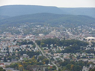
Altoona is a city in Blair County, Pennsylvania. It is the principal city of the Altoona Metropolitan Statistical Area (MSA). The population was 46,320 at the time of the 2010 Census, making it the eleventh most populous city in Pennsylvania. The Altoona MSA includes all of Blair County and was recorded as having a population of 127,089 at the 2010 Census, around 100,000 of whom live within a 5-mile (8.0 km) radius of the Altoona city center according to U.S. Census ZIP Code population data. This includes the adjacent boroughs of Hollidaysburg and Duncansville, adjacent townships of Logan, Allegheny, Blair, Frankstown, Antis, and Tyrone, as well as nearby boroughs of Bellwood and Newry.

Blantyre is a town and civil parish in South Lanarkshire, Scotland, with a population of 16,900. It is bounded by the River Clyde to the north, the Rotten Calder to the west, the Park Burn to the east and the Rotten Burn to the south.

Whiteley is a community in the county of Hampshire, England, near Fareham. The development straddles the boundary between two council districts: the Borough of Fareham to the south and east, and the city of Winchester to the north and west.
Ballincollig is a suburban town within the administrative area of Cork city in Ireland. It is located on the western side of Cork city, beside the River Lee on the R608 regional road. In 2016 it was the largest town in County Cork, at which time the Ballincollig Electoral Division had a population of 18,621 people. The nearest towns include Ballinora, Carrigrohane, Kilnaglory, Ovens, Killumney, Inniscarra, Blarney, and Tower. It is located beyond the green belt from the suburbs of Bishopstown and Wilton. Ballincollig is within the Cork North-West Dáil constituency.

Churchtown is a suburb of Southport, Merseyside, England. Historically in Lancashire, it is surrounded by Crossens, High Park and Marshside in the ancient parish of North Meols on the northern fringe of what is now Southport.
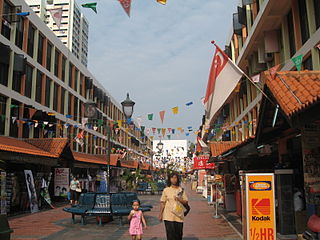
Toa Payoh is a planning area and matured residential town located in the northern part of the Central Region of Singapore. Toa Payoh planning area borders Bishan and Serangoon to the north, the Central Water Catchment to the northwest, Kallang to the south, Geylang to the southeast, Novena to the west and Hougang to the east. Toa Payoh New Town is situated in the eastern portion of the Toa Payoh planning area. The latter occupies a much larger area, encompassing estates such as Potong Pasir and Bidadari.

Abbeydale and Abbeymead are modern suburbs of the city of Gloucester in the county of Gloucestershire, England. They lie approximately 3 miles south-east of the city centre, and are bounded by the suburbs of Coney Hill to the north west, Barnwood and Hucclecote to the north and north east, Matson to the south west and the M5 motorway to the south and east. Mostly connected with Segregated Bicycle Paths into Gloucester city along Metz Way. The village of Upton St Leonards is directly across the M5 motorway.

Ryton is a town in the Metropolitan Borough of Gateshead, Tyne and Wear, England, 5.8 miles (9.3 km) west of Newcastle upon Tyne. Historically in County Durham, it was incorporated into the metropolitan county of Tyne and Wear and the Borough of Gateshead in 1974. In 2011, the population of the Ryton, Crookhill and Stella ward was 8,146.

Damanjodi is a town located in the Koraput district of the Indian state of Odisha in the Eastern Ghats. As of 2001, its population was 8,469. The town was founded as a residential area for employees of the National Aluminium Company (NALCO), a company that was established to harness the bauxite-rich deposits of the Panchpatmali Range. Damanjodi contains the NALCO Township, a residential area for employees of NALCO, Mathalput, a semi-urban neighborhood with shops, and Bhejaput, a shopping complex. The population is considered cosmopolitan in nature with employees from all over India and locals from the tribal region...
Damansara Jaya is a township consisting of Sections SS22 and SS22A of the city of Petaling Jaya in the state of Selangor, Malaysia. It is situated within the Sungai Buloh mukim (subdivision) of the Petaling district. It covers an estimated area of 1.21 km2 and has an estimated population of 11,678 residents.
Tama New Town is a large residential development, straddling the municipalities of Hachiōji, Tama, Inagi and Machida cities, in Tokyo, Japan. It was designed as a new town in 1965. It is approximately 14 kilometers long stretching east-west, and between 1 and 3 kilometers wide, located in an expanse of hills known as Tama Hills about 20 kilometers west of the center of the special wards of Tokyo.
Damansara Utama is a suburb of Petaling Jaya, Selangor, Malaysia. The suburb is divided into two sections, SS20 in the east and SS21 in the west which are separated in the middle by the Damansara–Puchong Expressway, a heavily used six-lane expressway. It has a population of about 142,000 people.

Sengkang is a planning area and residential town located in the North-East Region of Singapore. The town is the second most populous in the region, being home to 244,600 residents in 2019. Sengkang shares boundaries with Seletar and Punggol in the north, Pasir Ris and Paya Lebar in the east, Hougang and Serangoon to the south, as well as Yishun and Ang Mo Kio to the west.

Hempstead is a settlement near Gillingham, Kent in South East England. Historically a small hamlet, Hempstead grew throughout the 20th century to become part of the urban area of the Medway Towns. Hempstead is located on the southern edge of the Unitary authority of Medway, surrounded by Wigmore and the A278 trunk road to the east, Capstone valley to the west and the M2 motorway and the village of Bredhurst to the south. Most of Hempstead is in a valley, with Hempstead Valley Drive running along its length with housing on both sides.

Caerau[ˈkai̯r.ai] is a community in the west of Cardiff, capital city of Wales. Often considered part of Wenvoe by gully, Heol Trelai is the main road or avenue, lined with large trees. Dominated mostly by private housing, it has the Western Leisure Centre, supermarkets, schools and churches.

Weavering is a village, mainly consisting of parts of the Grove Green and Bearsted Park housing Estates, centred on Weavering Street, within the borough of Maidstone, Kent in South East England that was formerly farmland. At the 2014 Census the population of the village was included in the civil parish of Thurnham.

Girdle Toll is an area of Irvine, North Ayrshire.
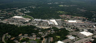
Butler Plaza is a large retail complex located in southwest Gainesville, Florida. It is the largest retail power center in Florida and among the largest in the southeast United States. Built on the former site of Stengel Airport, which closed in 1971, the shopping center currently consists of four major sections: East, Central, West, and North. Butler Town Center is currently under construction on the east side of the development.

Hamilton West is an area of the town of Hamilton in South Lanarkshire, Scotland.
Kern River County Park is a large recreation facility located just north of Bakersfield, California. The facility is 1,012 acres (4.10 km2), and includes a park, zoo, golf course, and other amenities. The complex is served by Alfred Harrell Highway. The segment to the west of the park was built as a 4-lane local freeway. The segment to the east of the park was built as a 2-lane expressway, with land reserved for a future 4-lane freeway.