
Gloucestershire is a ceremonial county in South West England. It is bordered by Herefordshire to the north-west, Worcestershire to the north, Warwickshire to the north-east, Oxfordshire to the east, Wiltshire to the south, Bristol and Somerset to the south-west, and the Welsh county of Monmouthshire to the west. The city of Gloucester is the largest settlement and the county town.

Ross-on-Wye is a market town and civil parish in Herefordshire, England, near the border with Wales. It had a population estimated at 10,978 in 2021. It lies in south-east of the county, on the River Wye and on the northern edge of the Forest of Dean.

Newent is a market town and civil parish in the Forest of Dean in Gloucestershire, England. The town is 11 miles (18 km) north-west of Gloucester. Its population was 5,073 at the 2001 census, rising to 5,207 in 2011, The population was 6,777 at the 2021 Census. Once a medieval market and fair town, its site had been settled at least since Roman times. The first written record of it appears in the 1086 Domesday Book.

Forest of Dean is a local government district in west Gloucestershire, England, named after the Forest of Dean. Its council is based in Coleford. Other towns and villages in the district include Blakeney, Cinderford, Drybrook, English Bicknor, Huntley, Littledean, Longhope, Lydbrook, Lydney, Mitcheldean, Newnham and Newent.

Goodrich is a village and civil parish in south Herefordshire, England close to Gloucestershire and the Forest of Dean, situated near the River Wye at grid reference SO574193. It is known for its Norman and mediaeval castle built with Old Red Sandstone.
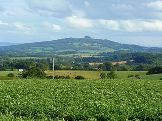
May Hill is a prominent English hill between Gloucester and Ross-on-Wye. Its summit, on the western edge of Gloucestershire and its northern slopes in Herefordshire, is distinguishable by a clump of trees on its summit, which forms an official Site of Special Scientific Interest. It is reached by three public footpaths, two as parts of the Gloucestershire Way and Wysis Way.

St Briavels, is a medium-sized village and civil parish in the Royal Forest of Dean in west Gloucestershire, England; close to the England-Wales border, and 5 miles (8 km) south of Coleford. It stands almost 800 feet (240 m) above sea level on the edge of a limestone plateau above the valley of the River Wye, above an ancient meander of the river. To the west, Cinder Hill drops off sharply into the valley. It is sheltered behind the crumbling walls of the 12th century St Briavels Castle.

Huntley, Gloucestershire, is a village on the A40 located seven miles (11 km) west of Gloucester. It is in the north of the Forest of Dean.

Aston Ingham is a village in south-eastern Herefordshire, England, near Newent and about 7 miles (11 km) east of Ross-on-Wye. The population of the village at the 2011 census was 398. There is a church, dedicated to St John the Baptist, which has been a Grade II* listed building since 17 March 1987.

Mitcheldean is a market town in the Forest of Dean in Gloucestershire, England.

Gorsley is a small village in the Forest of Dean district of Gloucestershire, England, forming part of the civil parish of Gorsley and Kilcot. Nearby Gorsley Common and Little Gorsley are both in Herefordshire.
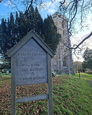
Upton Bishop is a small village in Herefordshire, England. The population of the village at the 2011 census was 602.

Rudford is a village and former civil parish, now in the parish of Rudford and Highleadon, in the Forest of Dean district, in the county of Gloucestershire, England. It is located approximately 4 miles (6 km) north-west of Gloucester and 5 miles (8 km) south-east of Newent. The local church is dedicated to St Mary. In 1931 the parish had a population of 114.

Newent Community School is a secondary school in Newent, Gloucestershire, England. It is an Academy of 1,340 students, serving the town and the rural community. The school provides secondary education for ages 11 to 18. The school offers GCSEs as well as A Levels. In 2001, the school was granted Arts College specialist status. In 2007 the school was also granted Science College as a second specialism. In addition, the school has been awarded Sportsmark Silver, Artsmark Gold and Healthy School. The school became an academy in 2012.
Winifred Mary Foley was an English writer. She is known best for an autobiographical account of her childhood in the Forest of Dean: A Child in the Forest (1974).
Mitcheldean Road railway station was a railway station that served the town of Mitcheldean 1.5 miles (2.4 km) to the south and the village of Lea in Herefordshire. Opened in 1855 with the line it was located on the Great Western Railway line linking Ross-on-Wye and Gloucester.
Upleadon is a village and civil parish situated 10.5 km north-west of Gloucester. Soon after the Norman conquest Upleadon became part of the estates of Gloucester Abbey and was recorded as such in the Domesday Book. Taking advantage of the nearby river, there was a period when iron forges were a focal point for the community but these were subsequently converted into a flour-mill. The village today extends southwards alongside the River Leadon and has a population of 213 according to the Gloucestershire County Council.

Bridstow is a village and civil parish in Herefordshire, England, 2 km west of Ross-on-Wye and 17 km south-east of Hereford. The parish is bounded to the east and south by the River Wye. The A40 road linking the M50 motorway to South Wales runs through the parish, crossing the Wye at Bridstow Bridge. The parish had a population of 906 in the 2011 UK census, and an estimated population of 941 in 2018.

Oxenhall is a village and civil parish 10 miles (16 km) north west of Gloucester, in the Forest of Dean district, in the county of Gloucestershire, England. In 2011 the parish had a population of 243. The parish touches Dymock, Gorsley and Kilcot, Kempley, Newent and Upton Bishop. Oxenhall has a parish meeting.

The number 32 is a bus route that operates from Gloucester to Newent, with some journeys continuing to Ross-on-Wye. It is run on a commercial basis.
