Related Research Articles

Efforts to scientifically ascertain and attribute mechanisms responsible for recent global warming and related climate changes on Earth have found that the main driver is elevated levels of greenhouse gases produced by human activities, with natural forces adding variability. The likely range of human-induced surface-level air warming by 2010–2019 compared to levels in 1850–1900 is 0.8 °C to 1.3 °C, with a best estimate of 1.07 °C. This is close to the observed overall warming during that time of 0.9 °C to 1.2 °C, while temperature changes during that time were likely only ±0.1 °C due to natural forcings and ±0.2 °C due to variability in the climate.

The National Oceanic and Atmospheric Administration is a Washington, D.C.–based scientific and regulatory agency within the United States Department of Commerce, a United States federal government department. The agency is charged with forecasting weather, monitoring oceanic and atmospheric conditions, charting the seas, conducting deep sea exploration, and managing fishing and protection of marine mammals and endangered species in the U.S. exclusive economic zone.

Satellite temperature measurements are inferences of the temperature of the atmosphere at various altitudes as well as sea and land surface temperatures obtained from radiometric measurements by satellites. These measurements can be used to locate weather fronts, monitor the El Niño-Southern Oscillation, determine the strength of tropical cyclones, study urban heat islands and monitor the global climate. Wildfires, volcanos, and industrial hot spots can also be found via thermal imaging from weather satellites.

The instrumental temperature record is a record of temperatures within Earth's climate based on direct, instrument-based measurements of air temperature and ocean temperature. Instrumental temperature records are distinguished from indirect reconstructions using climate proxy data such as from tree rings and ocean sediments. Instrument-based data are collected from thousands of meteorological stations, buoys and ships around the globe. Whilst many heavily-populated areas have a high density of measurements, observations are more widely spread in sparsely populated areas such as polar regions and deserts, as well as over many parts of Africa and South America. Measurements were historically made using mercury or alcohol thermometers which were read manually, but are increasingly made using electronic sensors which transmit data automatically. Records of global average surface temperature are usually presented as anomalies rather than as absolute temperatures. A temperature anomaly is measured against a reference value. For example, a commonly used baseline period is the time period 1951-1980.
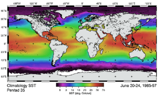
The Tropical Ocean Global Atmosphere program (TOGA) was a ten-year study (1985-1994) of the World Climate Research Programme (WCRP) aimed specifically at the prediction of climate phenomena on time scales of months to years.

The European Organisation for the Exploitation of Meteorological Satellites (EUMETSAT) is an intergovernmental organisation created through an international convention agreed by a current total of 30 European Member States.
CDR may refer to:

Sea surface temperature (SST), or ocean surface temperature, is the ocean temperature close to the surface. The exact meaning of surface varies according to the measurement method used, but it is between 1 millimetre (0.04 in) and 20 metres (70 ft) below the sea surface. Air masses in the Earth's atmosphere are highly modified by sea surface temperatures within a short distance of the shore. Localized areas of heavy snow can form in bands downwind of warm water bodies within an otherwise cold air mass. Warm sea surface temperatures are known to be a cause of tropical cyclogenesis over the Earth's oceans. Tropical cyclones can also cause a cool wake, due to turbulent mixing of the upper 30 metres (100 ft) of the ocean. SST changes diurnally, like the air above it, but to a lesser degree. There is less SST variation on breezy days than on calm days. In addition, ocean currents, such as the Atlantic Multidecadal Oscillation (AMO), can affect SST's on multi-decadal time scales, and a major impact results from the global thermohaline circulation, which affects average SST significantly throughout most of the world's oceans.

The global temperature record shows the fluctuations of the temperature of the atmosphere and the oceans through various spans of time. There are numerous estimates of temperatures since the end of the Pleistocene glaciation, particularly during the current Holocene epoch. Some temperature information is available through geologic evidence, going back millions of years. More recently, information from ice cores covers the period from 800,000 years before the present time until now. A study of the paleoclimate covers the time period from 12,000 years ago to the present. Tree rings and measurements from ice cores can give evidence about the global temperature from 1,000-2,000 years before the present until now. The most detailed information exists since 1850, when methodical thermometer-based records began. Modifications on the Stevenson-type screen were made for uniform instrument measurements around 1880.
The Advanced Very-High-Resolution Radiometer (AVHRR) instrument is a space-borne sensor that measures the reflectance of the Earth in five spectral bands that are relatively wide by today's standards. AVHRR instruments are or have been carried by the National Oceanic and Atmospheric Administration (NOAA) family of polar orbiting platforms (POES) and European MetOp satellites. The instrument scans several channels; two are centered on the red (0.6 micrometres) and near-infrared (0.9 micrometres) regions, a third one is located around 3.5 micrometres, and another two the thermal radiation emitted by the planet, around 11 and 12 micrometres.
The Group for High Resolution SST (GHRSST) is a follow on activity form the Global Ocean Data Assimilation Experiment (GODAE) high-resolution sea surface temperature pilot project. It provides a global high-resolution (<10 km) data products to the operational oceanographic, meteorological, climate and general scientific community, in real time and delayed mode.

OSTM/Jason-2, or Ocean Surface Topography Mission/Jason-2 satellite, was an international Earth observation satellite altimeter joint mission for sea surface height measurements between NASA and CNES. It was the third satellite in a series started in 1992 by the NASA/CNES TOPEX/Poseidon mission and continued by the NASA/CNES Jason-1 mission launched in 2001.

The US Climate Reference Network (USCRN) is a network of climate stations developed and maintained by the National Oceanic and Atmospheric Administration (NOAA), completed in 2008.. It has the long-term commitment of the Department of Commerce and the NOAA.
The Polar-orbiting Operational Environmental Satellite (POES) was a constellation of polar orbiting weather satellites funded by the National Oceanic and Atmospheric Administration (NOAA) and the European Organisation for the Exploitation of Meteorological Satellites (EUMETSAT) with the intent of improving the accuracy and detail of weather analysis and forecasting. The spacecraft were provided by NASA and the European Space Agency (ESA), and NASA's Goddard Space Flight Center oversaw the manufacture, integration and test of the NASA-provided TIROS satellites. The first polar-orbiting weather satellite launched as part of the POES constellation was the Television Infrared Observation Satellite-N (TIROS-N), which was launched on 13 October 1978. The final spacecraft, NOAA-19, was launched on 6 February 2009. The ESA-provided MetOp satellite operated by EUMETSAT utilize POES-heritage instruments for the purpose of data continuity. The Joint Polar Satellite System, which was launched on 18 November 2017, is the successor to the POES Program.
Microwave Sounding Unit temperature measurements refers to temperature measurement using the Microwave Sounding Unit instrument and is one of several methods of measuring Earth atmospheric temperature from satellites. Microwave measurements have been obtained from the troposphere since 1979, when they were included within NOAA weather satellites, starting with TIROS-N. By comparison, the usable balloon (radiosonde) record begins in 1958 but has less geographic coverage and is less uniform.
The UAH satellite temperature dataset, developed at the University of Alabama in Huntsville, infers the temperature of various atmospheric layers from satellite measurements of the oxygen radiance in the microwave band, using Microwave Sounding Unit temperature measurements.

The Joint Polar Satellite System (JPSS) is the latest generation of U.S. polar-orbiting, non-geosynchronous, environmental satellites. JPSS will provide the global environmental data used in numerical weather prediction models for forecasts, and scientific data used for climate monitoring. JPSS will aid in fulfilling the mission of the U.S. National Oceanic and Atmospheric Administration (NOAA), an agency of the Department of Commerce. Data and imagery obtained from the JPSS will increase timeliness and accuracy of public warnings and forecasts of climate and weather events, thus reducing the potential loss of human life and property and advancing the national economy. The JPSS is developed by the National Aeronautics and Space Administration (NASA) for the National Oceanic and Atmospheric Administration (NOAA), who is responsible for operation of JPSS. Three to five satellites are planned for the JPSS constellation of satellites. JPSS satellites will be flown, and the scientific data from JPSS will be processed, by the JPSS – Common Ground System (JPSS-CGS).

The Suomi National Polar-orbiting Partnership, previously known as the National Polar-orbiting Operational Environmental Satellite System Preparatory Project (NPP) and NPP-Bridge, is a weather satellite operated by the United States National Oceanic and Atmospheric Administration (NOAA). It was launched in 2011 and is currently in operation.
NOAA-20, designated JPSS-1 prior to launch, is the first of the United States National Oceanic and Atmospheric Administration's latest generation of U.S. polar-orbiting, non-geosynchronous, environmental satellites called the Joint Polar Satellite System. NOAA-20 was launched on 18 November 2017 and joined the Suomi National Polar-orbiting Partnership satellite in the same orbit. NOAA-20 operates about 50 minutes behind Suomi NPP, allowing important overlap in observational coverage. Circling the Earth from pole-to-pole, it crosses the equator about 14 times daily, providing full global coverage twice a day. This gives meteorologists information on "atmospheric temperature and moisture, clouds, sea-surface temperature, ocean color, sea ice cover, volcanic ash, and fire detection" so as to enhance weather forecasting including hurricane tracking, post-hurricane recovery by detailing storm damage and mapping of power outages.

The Sentinel-6 Michael Freilich (S6MF) is a radar altimeter satellite developed in partnership between several European and American organizations. It is part of the Jason satellite series and is named after Michael Freilich. S6MF includes synthetic-aperture radar altimetry techniques to improve ocean topography measurements, in addition to rivers and lakes. The spacecraft entered service in mid 2021 and is expected to operate for 5.5 years.
References
- ↑ "NSIDC DAAC Data Projects: Climate Data Records". Archived from the original on 2010-07-20. Retrieved 2010-09-22.
- ↑ http://www.nap.edu/catalog.php?record_id=10944 NRC (National Research Council) 2004. Climate Data Records from Environmental Satellites. Washington D.C.: National Academy Press.I SBN-10: 0-309-09168-3, ISBN 978-0-309-09168-8
- Approach to Providing Climate Data Records (CDRs) in Coordination with other US Agency Activities, Jeffrey L. Privette, John Bates, Thomas Karl, Bruce Barkstrom, Ed Kearns, and David Markham. 2009 AMS Conference Proceedings
- Climate Data Records From Environmental Satellites, Drobot et al.
- Creating Climate Data Records from NOAA Operational Satellites, a NOAA White Paper
- The Future of Climate Data Records