Related Research Articles

Mountaineering, mountain climbing, or alpinism, is a set of outdoor activities that involves ascending mountains. Mountaineering-related activities include traditional outdoor climbing, skiing, and traversing via ferratas that have become sports in their own right. Indoor climbing, sport climbing, and bouldering are also considered variants of mountaineering by some, but are part of a wide group of mountain sports.

Longs Peak is a high and prominent mountain in the northern Front Range of the Rocky Mountains of North America. The 14,259-foot (4346 m) fourteener is located in the Rocky Mountain National Park Wilderness, 9.6 miles (15.5 km) southwest by south of the Town of Estes Park, Colorado, United States. Longs Peak is the northernmost fourteener in the Rocky Mountains of Colorado and the highest point in Boulder County and Rocky Mountain National Park. The mountain was named in honor of explorer Stephen Harriman Long and is featured on the Colorado state quarter.

Tahquitz Peak is a granite, 8,846-foot-tall (2,696 m) rock formation located on the high western slope of the San Jacinto mountain range in Riverside County, Southern California, United States, above the mountain town of Idyllwild. Tahquitz has a steep approach hike, leading to a roughly 1000-foot face. Tahquitz, which can refer to both the rock outcrop and the outcrop's parent peak, is a popular hiking destination to the fire lookout station and the rock climbing area.

The Matterhorn is a mountain of the Alps, straddling the main watershed and border between Switzerland and Italy. It is a large, near-symmetric pyramidal peak in the extended Monte Rosa area of the Pennine Alps, whose summit is 4,478 metres (14,692 ft) high, making it one of the highest summits in the Alps and Europe. The four steep faces, rising above the surrounding glaciers, face the four compass points and are split by the Hörnli, Furggen, Leone/Lion, and Zmutt ridges. The mountain overlooks the Swiss town of Zermatt, in the canton of Valais, to the northeast; and the Italian town of Breuil-Cervinia in the Aosta Valley to the south. Just east of the Matterhorn is Theodul Pass, the main passage between the two valleys on its north and south sides, which has been a trade route since the Roman Era.
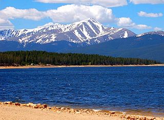
Mount Elbert is the highest summit of the Rocky Mountains, the highest point in the U.S. state of Colorado, and the second-highest summit in the contiguous United States. The ultra-prominent 14,440-foot (4401.2 m) fourteener is the highest peak in the Sawatch Range, as well as the highest point in the entire Mississippi River drainage basin. Mount Elbert is located in San Isabel National Forest, 12.1 miles (19.4 km) southwest of the City of Leadville in Lake County, Colorado.

Saxon Switzerland is a hilly climbing area and national park around the Elbe valley south-east of Dresden in Saxony, Germany. Together with the Bohemian Switzerland in the Czech Republic it forms the Elbe Sandstone Mountains.

Mount Asgard is a twin peaked mountain with two flat-topped, cylindrical, rock towers, separated by a saddle. It is located in Auyuittuq National Park, on the Cumberland Peninsula of Baffin Island, Nunavut, Canada. The peak is named after Asgard, the realm of the Æsir (gods) in Norse mythology. Mount Asgard is perhaps the most famous of the Baffin Mountains.
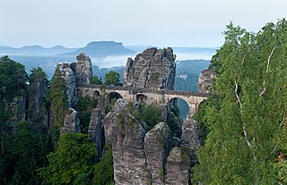
The Bastei is a rock formation rising 194 metres above the Elbe River in the Elbe Sandstone Mountains of Germany. Reaching a height of 305 metres above sea level, the jagged rocks of the Bastei were formed by water erosion over one million years ago. They are situated near Rathen, not far from Pirna southeast of the city of Dresden, and are the major landmark of the Saxon Switzerland National Park. They are also part of a climbing and hiking area that extends over the borders into the Bohemian Switzerland.

Kaaterskill High Peak is one of the Catskill Mountains, located in the Town of Hunter in Greene County, New York, United States. It was once believed to be the highest peak in the entire range, but its summit, at 3,655 feet in elevation, places it only 23rd among the Catskill High Peaks. It is, however, the fourth most prominent peak in the range. Due to its situation as the easternmost High Peak, its summit is just outside the watersheds of New York City's reservoirs in the region.
Saxon Switzerland National Park, is a national park in the German Free State of Saxony, near the Saxon capital Dresden. It covers two areas of 93.5 km² (36.1 mi²) in the heart of the German part of the Elbe Sandstone Mountains, which is often called (the) Saxon Switzerland.
Humpback Rock is a massive greenstone outcropping near the peak of Humpback Mountain in the Blue Ridge Mountains of Augusta County and Nelson County, Virginia, United States, with a summit elevation of 3,080 feet (940 m). The rock formation is so named for the visual effect of a "hump" it creates on the western face of the mountain.

The Großer Zschirnstein is the highest hill in the Saxon and German part of the Elbe Sandstone Mountains.

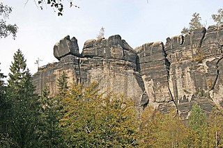
The Schrammsteine are a long, strung-out, very jagged group of rocks in the Elbe Sandstone Mountains located east of Bad Schandau in Saxon Switzerland in eastern Germany. To the north they are bordered by the Kirnitzsch valley, to the south by the Elbe valley and to the east by the Affensteine rocks. The high point of the chain lies at over 400 m above sea level (HN). The viewing point on the Schrammsteine lies at a height of 417.2 m above HN.

The Nonne is a roughly 18-metre-high, isolated, standing sandstone rock and climbing peak in Saxon Switzerland in Germany. The rock is located southeast of Rathen, east of the rock chain of Rauenstein.
The Mönch is a rock pinnacle and popular climbing peak in Saxon Switzerland in Germany near the spa town of Rathen. The weather vane on the summit, in the shape of a tin monk, is visible from afar and acts as a navigation aid.

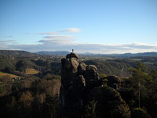
Saxon Switzerland is the largest and one of the best-known climbing regions in Germany, located in the Free State of Saxony. The region is largely coterminous with the natural region of the same name, Saxon Switzerland, but extends well beyond the territory of the National Park within it. It includes the western part of the Elbe Sandstone Mountains and is the oldest non-Alpine climbing region in Germany. Its history of climbing dates back to the first ascent in modern times of the Falkenstein by Bad Schandau gymnasts in 1864. Currently, there are over 1,100 summits with more than 17,000 climbing routes in the Saxon Switzerland area.
The Frienstein, also called the Vorderes Raubschloss, is a rock formation, about 130 metres high, in Saxon Switzerland. It lies on the northern slopes of the Großer Winterberg in the Affensteine rocks. On the rock there was once a watchtower of the Barony of Wildenstein. Today the Frienstein is a popular climbing peak.

The Teufelsturm is a prominent rock tower and climbing rock formed of Elbe Sandstone, about forty metres high in Saxon Switzerland in northeastern Germany. It is located east of the River Elbe on the upper edge of the valley between Schmilka and Bad Schandau in the Schrammsteinen. The Teufelsturm is also referred to as the "Symbol of Saxon Climbing".

The Kleiner Bärenstein is a 338 metres high table hill in the German region of Saxon Switzerland in the Free State of Saxony. Close by is the Großer Bärenstein which, together with the Kleiner Bärenstein, forms the massif of the Bärensteine.

Breccia Peak is a mountain in the southern Absaroka Range of the Rocky Mountains. It is located in Teton County in the U.S. state of Wyoming, close to the southwest border of the Teton Wilderness within the Bridger-Teton National Forest.
References
- ↑ Kelsey (2013), p. 170.
- ↑ Der Sächsische Bergsteigerbund, ed. (1 September 2009), "5.1 Klettergipfel", Sächsische Kletterregeln : Vollständige Fassung (in German), archived from the original (Webdokument) on 10 September 2011, retrieved 16 November 2009