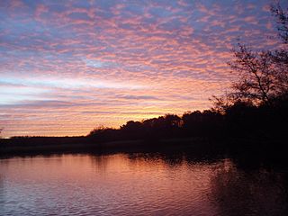
Fleet Pond is a 48.3-hectare (119-acre) biological Site of Special Scientific Interest in Fleet in Hampshire. It is also a Local Nature Reserve.

The Moonee Ponds Creek Trail is a shared use path for cyclists and pedestrians, which follows the Moonee Ponds Creek through the northern suburbs of Melbourne, Victoria, Australia.

The Capital City Trail is a shared use path in Melbourne, Victoria, Australia, which circles the city centre and some inner eastern and northern suburbs. It is 29km in length, and mostly consists of sections of other trails, such as the Merri Creek Trail, Main Yarra Trail, Moonee Ponds Creek Trail and Inner Circle Rail Trail.
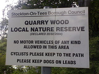
Quarry Wood is a small wooded area in Preston Park, Preston-on-Tees in County Durham, England. It was declared a Local Nature Reserve in 2004 by Stockton Borough Council.

Tuxbury Pond is a lake which straddles the Massachusetts-New Hampshire border, within the towns of Amesbury, Massachusetts and South Hampton, New Hampshire. It is located along the Powwow River. It has two islands in the middle, and a large summer camp resort lies along the Massachusetts shore.
Highway 925 is an unpaved provincial highway in the far northern region of the Canadian province of Saskatchewan. It begins about 10 kilometres (6.2 mi) south of Buffalo Narrows on Highway 155 and ends in Michel Village. It is about 76 kilometres (47 mi) long.

The M80 Trail is a shared-use path for cyclists and pedestrians that bridges the northern suburbs and follows the Western Ring Road/Metropolitan Ring Road (M80) freeway in Melbourne, Australia.

Railway Fields is a Local Nature Reserve and a Site of Borough Importance for Nature Conservation, Grade I, in Harringay the London Borough of Haringey. About one hectare in area, it was a railway goods yard until 1967.

The Lowell Holly Reservation is a 135-acre (0.55 km2) nature reserve in Mashpee and Sandwich, Massachusetts and is managed by the Trustees of Reservations. The area was extensively planted by A. Lawrence Lowell and Wilfred Wheeler with rhododendrons, mountain laurel and holly trees, for which the reservation gets its name. There are 4 miles (6.4 km) of hiking trails and two peninsular knolls that jut into Mashpee Pond and Wakeby Pond. Lowell bequeathed the property to the Trustees of Reservations in 1943.

Wabasca 166C is an Indian reserve of the Bigstone Cree Nation in Alberta, located within the Municipal District of Opportunity No. 17. In the 2016 Canadian Census, it recorded a population of 188 people living in 47 of its 58 total private dwellings. The community is located along the northeast shore of North Wabasca Lake.
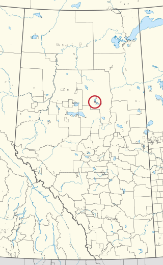
Wabasca 166B is an Indian reserve of the Bigstone Cree Nation in Alberta, located within the Municipal District of Opportunity No. 17. In the 2016 Canadian Census, it recorded a population of 190 living in 43 of its 52 total private dwellings. The community is located on the southern shore of North Wabasca Lake and to the west of the hamlet of Wabasca.
Khwai River Airport is an airport serving the lodges and camps around the village of Khwai in Botswana.

Burnt Ash Pond is a local nature reserve in Lee in the London Borough of Lewisham. It is a pond surrounded by railings in Melrose Close. It is not normally open to the public, but can be viewed from the road.

Horn Pond is a 102-acre (41 ha) water body along the Aberjona River in Woburn, Massachusetts in the United States. The pond is fed by several brooks and flows out via Horn Pond Brook to the Aberjona River and the Mystic Lakes, eventually reaching the Mystic River and the Atlantic Ocean. It was also traversed by the Middlesex Canal from 1802 to 1860.
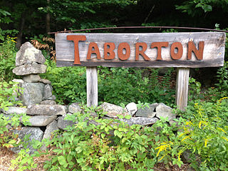
Taborton is a hamlet located within the town of Sand Lake in Rensselaer County, New York, United States. It is served by the Taborton Fire Department. Two large ponds, Big Bowman Pond and Little Bowman Pond, are in the immediate vicinity.

Fresh Ponds is an unincorporated community located within South Brunswick Township in Middlesex County, in the U.S. state of New Jersey. It is located in a rural portion of the township at the intersection of Fresh Ponds Road and Davidson Mill Road. Forest land, farms, homes, and a church are located around the settlement.
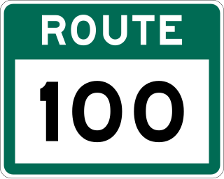
Route 100 is a major highway in Newfoundland and Labrador. The highway begins at its northern terminus at the Trans-Canada Highway in the town of Whitbourne, runs for 108 kilometres (67 mi) until it ends at its southern terminus, the town of Branch, where it transitions into Route 92. Motorists can drive along the coast of Placentia Bay once traveling south of Point Verde.
Shubael Pond is a 48-acre (190,000 m2) kettle pond on Flax Pond Road in Nickerson State Park in Barnstable, Massachusetts.

Route 222, also known as Salt Pond–Winterland Road, is a 10.3-kilometre-long (6.4 mi) north–south highway on the island of Newfoundland. It lies on the Burin Peninsula and connects the town of Winterland with the Salt Pond portion of Burin. There no other major intersections or communities of any kind throughout its length.
Trehgam is a town in Kupwara district of the Indian union territory of Jammu and Kashmir. The village is located at a distance of 7 km (4.3 mi) from district headquarters Kupwara town. Trehgam has recently been carved out as the sixth constituency of District Kupwara.

