Related Research Articles

Scattering is a term used in physics to describe a wide range of physical processes where moving particles or radiation of some form, such as light or sound, are forced to deviate from a straight trajectory by localized non-uniformities in the medium through which they pass. In conventional use, this also includes deviation of reflected radiation from the angle predicted by the law of reflection. Reflections of radiation that undergo scattering are often called diffuse reflections and unscattered reflections are called specular (mirror-like) reflections. Originally, the term was confined to light scattering. As more "ray"-like phenomena were discovered, the idea of scattering was extended to them, so that William Herschel could refer to the scattering of "heat rays" in 1800. John Tyndall, a pioneer in light scattering research, noted the connection between light scattering and acoustic scattering in the 1870s. Near the end of the 19th century, the scattering of cathode rays and X-rays was observed and discussed. With the discovery of subatomic particles and the development of quantum theory in the 20th century, the sense of the term became broader as it was recognized that the same mathematical frameworks used in light scattering could be applied to many other phenomena.

A nephelometer or aerosol photometer is an instrument for measuring the concentration of suspended particulates in a liquid or gas colloid. A nephelometer measures suspended particulates by employing a light beam and a light detector set to one side of the source beam. Particle density is then a function of the light reflected into the detector from the particles. To some extent, how much light reflects for a given density of particles is dependent upon properties of the particles such as their shape, color, and reflectivity. Nephelometers are calibrated to a known particulate, then use environmental factors (k-factors) to compensate lighter or darker colored dusts accordingly. K-factor is determined by the user by running the nephelometer next to an air sampling pump and comparing results. There are a wide variety of research-grade nephelometers on the market as well as open source varieties.
A photometer is an instrument that measures the strength of electromagnetic radiation in the range from ultraviolet to infrared and including the visible spectrum. Most photometers convert light into an electric current using a photoresistor, photodiode, or photomultiplier.

In physics, backscatter is the reflection of waves, particles, or signals back to the direction from which they came. It is usually a diffuse reflection due to scattering, as opposed to specular reflection as from a mirror, although specular backscattering can occur at normal incidence with a surface. Backscattering has important applications in astronomy, photography, and medical ultrasonography. The opposite effect is forward scatter, e.g. when a translucent material like a cloud diffuses sunlight, giving soft light.

AERONET - the AERONET is a network of ground-based sun photometers which measure atmospheric aerosol properties. The measurement system is a solar-powered CIMEL Electronique 318A spectral radiometer that measures Sun and sky radiances at a number of fixed wavelengths within the visible and near-infrared spectrum. There is one sea-based reading location aboard the E/V Nautilus, the exploration vessel operated by Dr. Robert Ballard and the Sea Research Foundation. Two readings per day are taken aboard the ship while it is in operation.

Over the last two centuries many environmental chemical observations have been made from a variety of ground-based, airborne, and orbital platforms and deposited in databases. Many of these databases are publicly available. All of the instruments mentioned in this article give online public access to their data. These observations are critical in developing our understanding of the Earth's atmosphere and issues such as climate change, ozone depletion and air quality. Some of the external links provide repositories of many of these datasets in one place. For example, the Cambridge Atmospheric Chemical Database, is a large database in a uniform ASCII format. Each observation is augmented with the meteorological conditions such as the temperature, potential temperature, geopotential height, and equivalent PV latitude.

Ocean color is the branch of ocean optics that specifically studies the color of the water and information that can be gained from looking at variations in color. The color of the ocean, while mainly blue, actually varies from blue to green or even yellow, brown or red in some cases. This field of study developed alongside water remote sensing, so it is focused mainly on how color is measured by instruments.
Particle size analysis, particle size measurement, or simply particle sizing, is the collective name of the technical procedures, or laboratory techniques which determines the size range, and/or the average, or mean size of the particles in a powder or liquid sample.

Ocean turbidity is a measure of the amount of cloudiness or haziness in sea water caused by individual particles that are too small to be seen without magnification. Highly turbid ocean waters are those with many scattering particulates in them. In both highly absorbing and highly scattering waters, visibility into the water is reduced. Highly scattering (turbid) water still reflects much light, while highly absorbing water, such as a blackwater river or lake, is very dark. The scattering particles that cause the water to be turbid can be composed of many things, including sediments and phytoplankton.
Angle-resolved low-coherence interferometry (a/LCI) is an emerging biomedical imaging technology which uses the properties of scattered light to measure the average size of cell structures, including cell nuclei. The technology shows promise as a clinical tool for in situ detection of dysplastic, or precancerous tissue.
Multiangle light scattering (MALS) describes a technique for measuring the light scattered by a sample into a plurality of angles. It is used for determining both the absolute molar mass and the average size of molecules in solution, by detecting how they scatter light. A collimated beam from a laser source is most often used, in which case the technique can be referred to as multiangle laser light scattering (MALLS). The insertion of the word laser was intended to reassure those used to making light scattering measurements with conventional light sources, such as Hg-arc lamps that low-angle measurements could now be made. Until the advent of lasers and their associated fine beams of narrow width, the width of conventional light beams used to make such measurements prevented data collection at smaller scattering angles. In recent years, since all commercial light scattering instrumentation use laser sources, this need to mention the light source has been dropped and the term MALS is used throughout.

Laser diffraction analysis, also known as laser diffraction spectroscopy, is a technology that utilizes diffraction patterns of a laser beam passed through any object ranging from nanometers to millimeters in size to quickly measure geometrical dimensions of a particle. This particle size analysis process does not depend on volumetric flow rate, the amount of particles that passes through a surface over time.
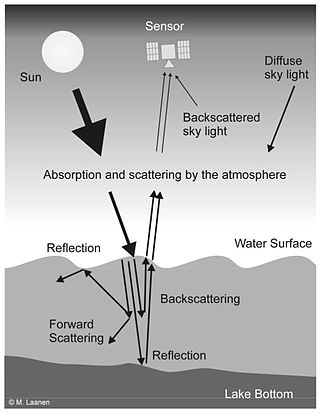
Water Remote Sensing is the observation of water bodies such as lakes, oceans, and rivers from a distance in order to describe their color, state of ecosystem health, and productivity. Water remote sensing studies the color of water through the observation of the spectrum of water leaving radiance. From the spectrum of color coming from the water, the concentration of optically active components of the upper layer of the water body can be estimated via specific algorithms. Water quality monitoring by remote sensing and close-range instruments has obtained considerable attention since the founding of EU Water Framework Directive.
Ground-based, flight-based, or satellite-based remote sensing instruments can be used to measure properties of the planetary boundary layer, including boundary layer height, aerosols and clouds. Satellite remote sensing of the atmosphere has the advantage of being able to provide global coverage of atmospheric planetary boundary layer properties while simultaneously providing relatively high temporal sampling rates. Advancements in satellite remote sensing have provided greater vertical resolution which enables higher accuracy for planetary boundary layer measurements.
Atmospheric lidar is a class of instruments that uses laser light to study atmospheric properties from the ground up to the top of the atmosphere. Such instruments have been used to study, among other, atmospheric gases, aerosols, clouds, and temperature.
Explorer 55, also called as AE-E, was a NASA scientific satellite belonging to series Atmosphere Explorer, being launched on 20 November 1975 from Cape Canaveral Air Force Station (CCAFS) board a Thor-Delta 2910 launch vehicle.
Mace Head Atmospheric Research Station is located on the West Coast of Ireland in Carna, and is one of the longest running mercury recording stations in the world. The stations location is highly important as it is far away from neighbouring cities to ensure no pollutants interfere with recordings, and its location is also highly important as it is ideal for studying the atmosphere under Northern Hemispheric and European conditions. The station has the dual status of being a World Meteorological Organization (WMO) Global Atmosphere Watch (GMO) station and a European Monitoring and Evaluation Program (EMEP) supersite. Mace Head research and monitor the climate and atmospheric composition, focusing on aerosol-cloud interactions and mercury readings.

The North Atlantic Aerosols and Marine Ecosystems Study (NAAMES) was a five-year scientific research program that investigated aspects of phytoplankton dynamics in ocean ecosystems, and how such dynamics influence atmospheric aerosols, clouds, and climate. The study focused on the sub-arctic region of the North Atlantic Ocean, which is the site of one of Earth's largest recurring phytoplankton blooms. The long history of research in this location, as well as relative ease of accessibility, made the North Atlantic an ideal location to test prevailing scientific hypotheses in an effort to better understand the role of phytoplankton aerosol emissions on Earth's energy budget.
Spectroscopic optical coherence tomography (SOCT) is an optical imaging and sensing technique, which provides localized spectroscopic information of a sample based on the principles of optical coherence tomography (OCT) and low coherence interferometry. The general principles behind SOCT arise from the large optical bandwidths involved in OCT, where information on the spectral content of backscattered light can be obtained by detection and processing of the interferometric OCT signal. SOCT signal can be used to quantify depth-resolved spectra to retrieve the concentration of tissue chromophores (e.g., hemoglobin and bilirubin), characterize tissue light scattering, and/or used as a functional contrast enhancement for conventional OCT imaging.

Ocean optics is the study of how light interacts with water and the materials in water. Although research often focuses on the sea, the field broadly includes rivers, lakes, inland waters, coastal waters, and large ocean basins. How light acts in water is critical to how ecosystems function underwater. Knowledge of ocean optics is needed in aquatic remote sensing research in order to understand what information can be extracted from the color of the water as it appears from satellite sensors in space. The color of the water as seen by satellites is known as ocean color. While ocean color is a key theme of ocean optics, optics is a broader term that also includes the development of underwater sensors using optical methods to study much more than just color, including ocean chemistry, particle size, imaging of microscopic plants and animals, and more.
References
Quinn, P. K., and D. J. Coffman (1998), Local closure during the First Aerosol Characterization Experiment (ACE 1): Aerosol mass concentration and scattering and backscattering coefficients, J. Geophys. Res., 103(D13), 16,575–16,596, doi : 10.1029/97JD03757.