Related Research Articles

Pushmataha County is a county in the southeastern part of the U.S. state of Oklahoma. As of the 2020 census, the population was 10,812. Its county seat is Antlers.
Pickens is an unincorporated community in western McCurtain County, Oklahoma, United States. The community is in the Silver Creek Valley in the Ouachita Mountains. The community of Clebit lies adjacent to the southwest along Little Silver Creek.
Moyers is an unincorporated community located in Pushmataha County, Oklahoma, United States.
Cloudy is an unincorporated community located in Pushmataha County, Oklahoma, United States. It is 12 miles northeast of Rattan. Cloudy is located at 34°18′07″N95°16′52″W.

The Kiamichi Mountains are a mountain range in southeastern Oklahoma. A subrange within the larger Ouachita Mountains that extend from Oklahoma to western Arkansas, the Kiamichi Mountains sit within Le Flore, Pushmataha and McCurtain counties near the towns of Poteau, Albion and Smithville. The foothills of the Kiamichi Mountains sit within Haskell County, Northern Latimer County and Northern Pittsburg County. Its peaks, which line up south of the Kiamichi River, reach 2,500 feet in elevation. The range was the namesake of Kiamichi Country, the official tourism designation for southeastern Oklahoma, until the designation was changed to Choctaw Country.
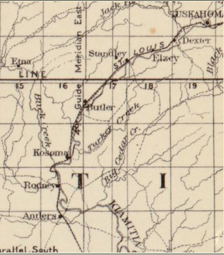
Kosoma is a ghost town and former railroad station in Pushmataha County, Oklahoma, United States. It is located just off Oklahoma State Highway 2, approximately 10 miles (16 km) north of Antlers.
Clear Boggy Creek, also known as the Clear Boggy River, is a 132-mile-long (212 km) creek in southeastern Oklahoma that is a tributary of Muddy Boggy Creek.
Buck Creek is a 38.9-mile-long (62.6 km) stream in Pushmataha County, Oklahoma. It flows generally southward from its headwaters in the western Kiamichi Mountains to its confluence with the Kiamichi River.
Rodney Mountain is located in Pushmataha County, Oklahoma, approximately five miles northwest of Antlers, Oklahoma. It is a part of the Kiamichi Mountains, a subrange of the Ouachita Mountains, and forms its southwest-most extremity. Its summit is 767 feet above sea level. It is found at GPS coordinates 34.2984336 and −95.6410833.
Dunbar is a community in Pushmataha County, Oklahoma, United States, 17 miles north of Antlers.
Fewell is a community in eastern Pushmataha County, Oklahoma, United States. Fewell is located at 34°31′05″N95°03′14″W.
Finley is an unincorporated community and Census designated place in Pushmataha County, Oklahoma, 10 miles northeast of Antlers.
Jumbo is an unincorporated community in western Pushmataha County, Oklahoma, United States, 10 miles north of Miller.
Miller is an unincorporated community in southwestern Pushmataha County, Oklahoma, United States. It is 10 miles northwest of Antlers and a short distance west of Moyers.
Nolia is a former community in eastern Pushmataha County, Oklahoma, United States. It is five miles east of Nashoba. Nolia is located at 34°28′35″N95°09′06″W at an elevation of 722 feet.
Rodney is a former community in Pushmataha County, Oklahoma, United States, five miles north of Antlers.
Sardis was a community in northern Pushmataha County, Oklahoma. United States. The location is six miles northwest of Clayton.
Sobol is an unincorporated community in southeastern Pushmataha County, Oklahoma, United States.
Pine Creek Wildlife Management Area is a scientifically managed preserve of natural and native wildlife flora and fauna. It is located in Pushmataha County and McCurtain County, Oklahoma, adjacent to Pine Creek Lake, seven miles north of Valliant, Oklahoma.
Johns Valley is a geographic feature and place name located in the Kiamichi Mountains in northwestern Pushmataha County, Oklahoma. The valley] is formally classified by geologists as a “basin” due to its complete encirclement by mountains.
References
- ↑ U.S. Geological Survey Geographic Names Information System: Cloudy Creek
- ↑ Moyer, Armond; Moyer, Winifred (1958). The origins of unusual place-names. Keystone Pub. Associates. p. 25.
34°19′39″N95°11′56″W / 34.327602°N 95.198848°W