
Old Oswestry is a large early Iron Age hill fort in the Welsh Marches near Oswestry in north west Shropshire, England. The earthworks, which remain one of the best preserved hill forts in the UK, have been described as "The Stonehenge of the Iron Age Period". After the hill fort was abandoned, it was incorporated into Wat's Dyke by the Mercians during the Early Medieval period.

Skelmorlie is a village in North Ayrshire in the southwest of Scotland. Although it is the northernmost settlement in the council area of North Ayrshire, it is contiguous with Wemyss Bay, which is in Inverclyde. The dividing line is the Kelly Burn, which flows into the Firth of Clyde just south of the Rothesay ferry terminal. Despite their proximity, the two villages have historically been divided, Skelmorlie in Ayrshire and Wemyss Bay in Renfrewshire.

Bridge of Allan, also known colloquially as Bofa, is a former spa town in the Stirling council area in Scotland, just north of the city of Stirling.

Forres is a town and former royal burgh in the north of Scotland on the Moray coast, approximately 25 miles (40 km) northeast of Inverness and 12 miles (19 km) west of Elgin. Forres has been a winner of the Scotland in Bloom award on several occasions. There are many geographical and historical attractions nearby such as the River Findhorn, and there are also classical, historical artifacts and monuments within the town itself, such as Forres Tolbooth and Nelson's Tower. Brodie Castle, the home of the Brodie Clan, lies to the west of the town, close to the A96.

The Findhorn Foundation is a Scottish charitable trust registered in 1972, formed by the spiritual community at the Findhorn Ecovillage, one of the largest intentional communities in Britain. It has been home to thousands of residents from more than 40 countries. The Foundation closed all its educational programmes in September 2023 whereas the Findhorn community eco village at Findhorn houses about 40 community businesses such as the Findhorn Press and an alternative medicine centre.

Craiglockhart Hydropathic, now a part of Edinburgh Napier University and known as Craiglockhart Campus, is a building with surrounding grounds in Craiglockhart, Edinburgh, Scotland. As part of a large extension programme by the university in the early 2000s the original building and surrounding campus underwent significant restoration and modernisation; as a result, many of the original interior features of the building are no longer visible. The exterior of the building has been preserved.

Hydrotherapy, formerly called hydropathy and also called water cure, is a branch of alternative medicine, occupational therapy, and physiotherapy, that involves the use of water for pain relief and treatment. The term encompasses a broad range of approaches and therapeutic methods that take advantage of the physical properties of water, such as temperature and pressure, to stimulate blood circulation, and treat the symptoms of certain diseases.
The River Findhorn is one of the longest rivers in Scotland. Located in the north east, it flows into the Moray Firth on the north coast. It has one of the largest non-firth estuaries in Scotland.

Seamill is a village in North Ayrshire on the west coast of Scotland, about 5 miles north of Ardrossan and 8 miles south of Largs, on the east coast of the Firth of Clyde.

Shandon is an affluent settlement of houses forming a village on the open sea loch of the Gare Loch in Argyll and Bute, Scotland. Shandon overlooks the Rosneath Peninsula to the west and is bordered by Glen Fruin to the east, which is the site of the Battle of Glen Fruin, one of the last clan battles in Scotland, fought on 7 February 1603, in which an estimated 300 warriors on foot from the MacGregor Clan claimed victory over an estimated 600–800 men from the Colquhoun Clan on horse-back.

Dunnideer Castle, now ruined, was a tower house located near Insch, Aberdeenshire, Scotland. It was built c. 1260 partially from the remains of an existing vitrified hill fort in the same location. It consisted of a single rectangular tower of 15 m by 12.5 m with walls 1.9 m thick. Evidence suggests that a first-floor hall existed and that it had several floors.

The Trundle is an Iron Age hillfort on St Roche's Hill about 4 miles (6 km) north of Chichester, West Sussex, England. It was built on the site of a causewayed enclosure, a form of early Neolithic earthwork found in northwestern Europe. Causewayed enclosures were built in England from shortly before 3700 BC until at least 3500 BC; they are characterized by the full or partial enclosure of an area with ditches that are interrupted by gaps, or causeways. Their purpose is not known; they may have been settlements, meeting places, or ritual sites. Hillforts were built as early as 1000 BC, in the Late Bronze Age, and continued to be built through the Iron Age until shortly before the Roman occupation.

Kelsborrow Castle is an Iron Age hill fort in Cheshire, northern England. Hill forts were fortified hill-top settlements constructed across Britain during the Iron Age. It is one of only seven hill forts in the county of Cheshire and was probably in use for only a short time. In the 19th century, a bronze palstave was recovered from the site. It is protected as a Scheduled Ancient Monument.
Hillforts in Britain refers to the various hillforts within the island of Great Britain. Although the earliest such constructs fitting this description come from the Neolithic British Isles, with a few also dating to later Bronze Age Britain, British hillforts were primarily constructed during the British Iron Age. Some of these were apparently abandoned in the southern areas that were a part of Roman Britain, although at the same time, those areas of northern Britain that remained free from Roman occupation saw an increase in their construction. Some hillforts were reused in the Early Middle Ages, and in some rarer cases, into the Later Medieval period as well. By the early modern period, these had essentially all been abandoned, with many being excavated by archaeologists in the nineteenth century onward.
Events from the year 1812 in Scotland.
Pinnata Castra was a settlement located in the north of the island of Great Britain, featuring in Ptolemy's 2nd century Geography as one of the four places listed as belonging to the Vacomagi tribe. It is also included as Pinnatis in the Ravenna Cosmography.
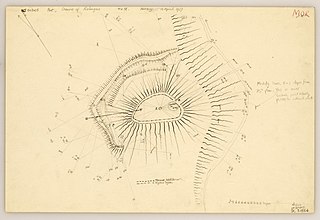
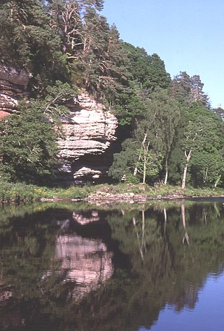
The Doune of Relugas is a hill fort located 9.25 kilometres (5.75 mi) south south west of Forres in Moray, Scotland. It is situated on a rocky knoll rising to approximately 400 feet (120 m) above ordnance datum and forming the south east part of the promontory at the confluence of the River Findhorn and the River Divie. The site commands an uninterrupted view of the valley of the Findhorn as far as Culbin Sands, 9 miles to the north on the shore of the Moray Firth.

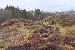
Dunearn is a hill fort located 15 kilometres (9.3 mi) south south east of Nairn in Highland, Scotland. It is situated on a steep-sided hill called Doune rising to approximately 266 metres (873 ft) above ordnance datum just south of Dulsie Bridge in the parish of Ardclach.
Northshield Rings is a prehistoric site, a hillfort near the village of Eddleston and about 6 miles (10 km) north of Peebles, in the Scottish Borders, Scotland. It is a Scheduled Monument.

White Meldon is a prehistoric site, a hillfort near the village of Lyne and about 4 miles (6 km) west of Peebles, in the Scottish Borders, Scotland. It is a Scheduled Monument.

