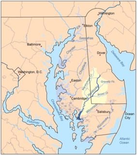
Marshyhope Creek is a 37.0-mile-long (59.5 km) tributary of the Nanticoke River on the Delmarva Peninsula. It rises in Kent County, Delaware, and runs through Caroline County, Maryland, and Dorchester County, Maryland.

Tenmile Creek is a stream in Washington and Greene Counties, Pennsylvania, USA. It is a tributary of the Monongahela River.

Taylor Run is a small tributary of Slippery Rock Creek in western Pennsylvania. The stream rises in southern Mercer County near Drake and flows south into Lawrence County entering Slippery Rock Creek upstream of Harlansburg, Pennsylvania. The watershed is roughly 60% agricultural, 30% forested and the rest is other uses.

Jamison Run is a small tributary of Slippery Rock Creek in western Pennsylvania. The stream rises in northern Lawrence County and flows south entering Slippery Rock Creek at Elliotts Mills, Pennsylvania. The watershed is roughly 46% agricultural, 45% forested and the rest is other uses.

Black Run is a small tributary of Slippery Rock Creek in western Pennsylvania. The stream rises in northwestern Butler County and flows northwest entering Slippery Rock Creek south of Elliotts Mills, Pennsylvania. The watershed is roughly 48% agricultural, 45% forested and the rest is other uses.

Big Run is a small tributary of Slippery Rock Creek in western Pennsylvania. The stream rises in northwestern Butler County and flows northwest entering Slippery Rock Creek just east of Crolls Mills, Pennsylvania. The watershed is roughly 26% agricultural, 65% forested and the rest is other uses.

Glade Run is a small tributary of Slippery Rock Creek in western Pennsylvania. The stream rises in northwestern Butler County and flows northwest entering Slippery Rock Creek at Slippery Rock Park, Pennsylvania. The watershed is roughly 42% agricultural, 51% forested and the rest is other uses.

Long Run is a small tributary of Slippery Rock Creek in western Pennsylvania. The stream rises in northwestern Butler County and flows south entering Slippery Rock Creek at Camp Bucoco, Pennsylvania. The watershed is roughly 49% agricultural, 44% forested and the rest is other uses.

McMurray Run is a small tributary of Slippery Rock Creek in western Pennsylvania. The stream rises in northwestern Butler County and flows south entering Slippery Rock Creek at Rock Hill Camp. The watershed is roughly 39% agricultural, 53% forested and the rest is other uses.

Camp Run is a tributary of Connoquenessing Creek in western Pennsylvania. The stream rises in southeastern Lawrence County and flows south entering Connoquenessing Creek at Fombell, Pennsylvania. The watershed is roughly 39% agricultural, 55% forested and the rest is other uses.

Scholars Run is a tributary of Connoquenessing Creek in western Pennsylvania. The stream rises in southwestern Butler County and flows south entering Connoquenessing Creek at Harmony, Pennsylvania. The watershed is roughly 36% agricultural, 53% forested and the rest is other uses.

Hottenbaugh Run is a tributary of Neshannock Creek in western Pennsylvania. The stream rises in east-central Lawrence County and flows south then west entering Neshannock Creek at Painter Hill. The watershed is roughly 53% agricultural, 40% forested and the rest is other uses.

Potter Run is a tributary to Neshannock Creek in western Pennsylvania. The stream rises in south-central Lawrence County and flows west and enters Neshannock Creek just downstream of Volant, Pennsylvania. The watershed is roughly 50% agricultural, 44% forested and the rest is other uses.

Indian Run is a tributary to Neshannock Creek in western Pennsylvania. The stream rises in south-central Mercer County and flows southeast entering Neshannock Creek at Leesburg, Pennsylvania. The watershed is roughly 61% agricultural, 32% forested and the rest is other uses.

Pine Run is a tributary to Neshannock Creek in western Pennsylvania. The stream rises in southeastern Mercer County and flows west entering Neshannock Creek south and downstream of Mercer, Pennsylvania. The watershed is roughly 41% agricultural, 50% forested and the rest is other uses.

Pine Run is a tributary to Neshannock Creek in western Pennsylvania. The stream rises in south-central Mercer County and flows southeast entering Neshannock Creek south and downstream of Mercer, Pennsylvania. The watershed is roughly 46% agricultural, 45% forested and the rest is other uses.

Pumpkin Run is a tributary to the Monongahela River in southwestern Pennsylvania. The stream rises in northeastern Greene and flows north entering the Monongahela River at Rices Landing, Pennsylvania. The watershed is roughly 31% agricultural, 58% forested and the rest is other uses. The population in the watershed is 931 (2010).

Castile Run is a small tributary to South Fork Tenmile Creek in southwestern Pennsylvania. The stream rises in northeastern Greene County and flows southeast entering South Fork Tenmile Creek at Chartiers, Pennsylvania. The watershed is roughly 25% agricultural, 69% forested and the rest is other uses.

Browns Run is a small tributary to South Fork Tenmile Creek in southwestern Pennsylvania. The stream rises in northeastern Greene County and flows south-southeast entering South Fork Tenmile Creek at Mather, Pennsylvania. The watershed is roughly 31% agricultural, 61% forested and the rest is other uses.


