
Coaltown Museum is a museum of coalmining, located in Westport on the West Coast of New Zealand. [1]
Coaltown Museum is a museum of coalmining, located in Westport on the West Coast of New Zealand. [1]
The building housing the Coaltown Museum is located in a cultural hub on Palmerston Street. [2] Designed by Boon Goldsmith Bhaskar Brebner Team Architects, the building won two awards in the 2013 New Zealand Institute of Architects Nelson/Marlborough regional awards: the public architecture award and the Resene colour award. [3]
The museum was opened in 2013, and holds displays on coal extraction and maritime history. The displays include an eight-ton coal wagon that was used at the Denniston mine; a simulated underground mine and a steam engine from the SS Mawhera. The museum also holds collections of photographs and objects related to mining on the West Coast. [4]

Nelson is a New Zealand city and unitary authority on the eastern shores of Tasman Bay at the top of the South Island. It is the oldest city in the South Island and the second-oldest settled city in New Zealand; it was established in 1841 and became a city by royal charter in 1858.
Greymouth is the largest town in the West Coast region in the South Island of New Zealand, and the seat of the Grey District Council. The population of the whole Grey District is 14,250, which accounts for 43% of the West Coast's inhabitants. The Greymouth urban area had an estimated population of 8,340. A large proportion of the District, 65%, is part of the Conservation Estate owned and managed by the Department of Conservation making Greymouth a natural centre for walkers and trampers.

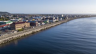
Westport is a town in the West Coast region of the South Island of New Zealand. Established in 1861, it is the oldest European settlement on the West Coast. Originally named Buller, it is on the right bank and at the mouth of the Buller River, close by the prominent headland of Cape Foulwind. It is connected via State Highway 6 with Greymouth, 100 kilometres (62 mi) to the south, and with Nelson 222 kilometres (138 mi) in the northeast, via the Buller Gorge. The population of the Westport urban area was 4,250 as of June 2023. The Buller District had a population of 9,670.
Denniston is a small settlement, 15 kilometres east of Westport, on the West Coast of the South Island of New Zealand. It is situated on the Denniston Plateau, 600 metres (2,000 ft) above sea level in the Papahaua Ranges.

Reefton is a small town in the West Coast region of New Zealand, some 80 km northeast of Greymouth, in the Inangahua River valley. Ahaura is 44 km south-west of Reefton, Inangahua Junction is 34 km to the north, Maruia is 63 km to the east, and the Lewis Pass is 66 km to the south-east.
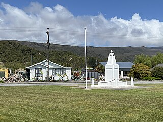
Waimangaroa is a small town located on the West Coast of New Zealand.

The Stillwater Ngākawau Line (SNL), formerly the Stillwater–Westport Line (SWL) and the Ngakawau Branch, is a secondary main line, part of New Zealand's national rail network. It runs between Stillwater and Ngakawau via Westport on the West Coast of the South Island. It was one of the longest construction projects in New Zealand's history, with its first section, at the south end, opened in 1889, and the beginnings of the Ngākawau Branch, at its Westport end, in 1875. The full line was completed in 1942. The only slower railway projects were Palmerston North to Gisborne, 1872 to 1942, and the Main North Line to Picton, 1872 to 1945.
The Papahaua Range is a mountain range on the West Coast of New Zealand's South Island east of the town of Westport. It is a geological continuation of the Paparoa Range that is south of the Buller River and it runs north from the Buller Gorge to the Mōkihinui River. At its north end, it meets the Glasgow Range.

Seddonville is a lightly populated locality on the West Coast of New Zealand's South Island. It is most famous for the historical role it played in New Zealand's coal mining industry.

The Cypress Mine is an extension to the open-cast coal mine the Stockton Mine’s operational area, to the east into the Upper Waimangaroa Mining Permit area, on the West Coast of New Zealand. The mine commenced operation in 2014.
Buller is a former New Zealand parliamentary electorate, from 1871 to 1972. It was represented by eleven Members of Parliament.

The Westport News is an independently-owned evening newspaper published in Westport, New Zealand. It is published on weekdays, and is one of New Zealand's smallest independent newspapers. The Westport News is distributed from Karamea in the north to Punakaiki in the south and as far inland as Reefton.

Taylorville is a small town on the banks of the Grey River, It is roughly 10 kilometers from the mouth of the river in Greymouth.

The Charming Creek Tramway was a 9 kilometres (5.6 mi) long private bush tramway at Ngakawau in Buller District on the West Coast in New Zealand. It was used from 1903 or 1905 to 1958.

Wallsend is a locality in the West Coast region of New Zealand, located on the south side of the Grey River. It is located opposite Taylorville. The two settlements were connected via a suspension bridge for pedestrians that was known as the Taylorville bridge.

History House Museum is a collection of photographic and archival records and historical objects relating to Grey District on the West Coast of New Zealand. The museum opened in the former Grey County Council Chambers in 1996, but the building was deemed unsafe in the event of an earthquake and forced to close in 2017. A new home for the collection is being sought.

Coast FM is a local radio station in Westport, New Zealand, to most of the West Coast Region. The station began in 1995 as Radio Fifeshire Westport in partnership with Fifeshire FM in Nelson, and started broadcasting in Hokitika and Greymouth in 1996. The station was rebranded as Coast FM in 1999, but is not related to Coast network that broadcasts in other parts of the country. It used to broadcast from the Westport News offices in the former BNZ building on Palmerston Street.

St Canice's Church in Westport, New Zealand, is a Catholic parish church, designed by John Scott. Consecrated in 1976, it is the second church on the site, replacing the earlier St Canice's designed by Francis Petre and completed in 1888.
Reefton Hospital is a hospital in Reefton on the West Coast of New Zealand. It was founded in 1872 and its closure was announced in 2024.
The Pounamu Pathway is a $34.5 million New Zealand tourism venture, launched in 2020 by the Māori hapū or subtribe Te Rūnanga o Ngāti Waewae, intended to create four linked visitor experience centres on the West Coast of the South Island. The visitor centres will tell stories of the West Coast's early Māori history and the importance of pounamu or greenstone.
41°45′14.6″S171°35′55.1″E / 41.754056°S 171.598639°E
| | This article related to a museum in New Zealand is a stub. You can help Wikipedia by expanding it. |