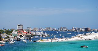
Destin is a city located in Okaloosa County, Florida, United States. It is a principal city of the Crestview–Fort Walton Beach–Destin metropolitan area.

Tobago is an island and ward within the Republic of Trinidad and Tobago. It is located 35 kilometres (22 mi) northeast of the larger island of Trinidad and about 160 kilometres (99 mi) off the northeastern coast of Venezuela. It also lies to the southeast of Grenada.

Gulf Islands National Park Reserve is a national park located on and around the Gulf Islands in British Columbia, Canada. In the National Parks System Plan, this park provides representation of the Strait of Georgia Lowlands natural region, the only place in Canada with a Mediterranean climate of dry, sunny summers and mild, wet winters, the result of a rain shadow effect from surrounding mountains between the region and the ocean. It has similar dominant vegetation as the Pacific Northwest, such as coastal Douglas-fir, western red cedar, shore pine, Pacific dogwood, bigleaf maple, and red alder, but also contains the northern extent of some of the more drought tolerant trees such as Garry oak and Arbutus. The park was created in 2003 as the fortieth national park. It covers 36 square kilometres (14 sq mi) of area on 16 islands and more than 30 islets, reefs and surrounding waters, making it the sixth smallest national park in Canada.

Teraina is a coral atoll in the central Pacific Ocean and part of the Northern Line Islands which belong to Kiribati. Obsolete names of Teraina are New Marquesas, Prospect Island, and New York Island. The island is located approximately 4.71° North latitude and 160.76° West longitude. Teraina differs from most other atolls in the world in that it has a large freshwater lake, an open lens, concealed within its luxuriant coconut palm forest; this is the only permanent freshwater lake in the whole of Kiribati.

Gaillard Island is an artificially created island located in Mobile Bay near Mobile, Alabama. It was built by the United States Army Corps of Engineers, using sand and mud dredged from the Mobile Bay ship channel and elsewhere. The island is an important site for colonial nesting seabirds and shore birds in coastal Alabama and has been the only nesting site for brown pelicans in Alabama - first discovered in 1983.

Cayo Costa State Park is a state park in the U.S. state of Florida, on Cayo Costa, an island directly south of Boca Grande and just north of North Captiva Island, approximately 12 miles (19 km) west of Cape Coral. The park is accessible only by charter boat, private boat, ferry or helicopter.
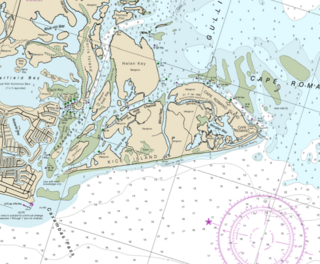
Cape Romano is a cape on the Gulf Coast of Florida, United States. It is on Cape Romano Island, one of a group of islands known collectively as Kice-Morgan Island.
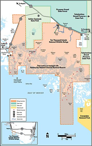
The Ten Thousand Islands are a chain of islands and mangrove islets off the coast of southwest Florida, between Cape Romano and the mouth of the Lostmans River. Some of the islands are high spots on a submergent coastline. Others were produced by mangroves growing on oyster bars. Despite the name, the islets in the chain only number in the hundreds.

Keewaydin Island is a primary barrier island located off the coast of Naples, in Collier County, Florida, United States. It can be reached only by boat. It is managed by the State of Florida's Coastal Office, in cooperation with NOAA, within the Rookery Bay National Estuarine Research Reserve. Keewaydin Island is monitored nightly for Loggerhead turtle nesting activity by The Conservancy of Southwest Florida.

Waterhouse Island, part of the Waterhouse Island Group, is a 287-hectare (710-acre) granite island situated in Banks Strait, part of Bass Strait, lying close to the north-eastern coast of Tasmania, Australia.

Kasatochi Island, also known as Kasatochi volcano, is an active stratovolcano and part of the Andreanof Islands subgroup of the Aleutian Islands of southwestern Alaska. On 7 August 2008, Kasatochi began erupting explosively with an ash plume reaching 45,000 feet (14,000 m). The eruption lasted for 24 hours and destroyed most life on the island. It currently does not support any consistent human population.
Rookery Bay Reserve protects 110,000 acres of coastal lands and waters at the northern end of the Ten Thousand Islands on the gulf coast of Florida, Rookery Bay National Estuarine Research Reserve represents one of the few remaining undisturbed mangrove estuaries in North America.
Raine Island is a vegetated coral cay 32 hectares in total area situated on the outer edges of the Great Barrier Reef off northeastern Australia. It lies approximately 620 km (390 mi) north-northwest of Cairns in Queensland, about 120 kilometres (75 mi) east-northeast of Cape Grenville on the Cape York Peninsula.

Holland Island was a marshy, rapidly eroding island in the Chesapeake Bay, in Dorchester County, Maryland, west of Salisbury. The island was once inhabited by watermen and farmers but has since been abandoned due to sinking of the land's surface associated with isostatic subsidence and sea level rise. It is located in the Holland Strait, between Bloodsworth Island and Smith Island, six miles west of Wenona, Maryland and Southeast of another former island, Long Island.

Hope Island is a small tadpole shaped Island situated off the coast of Kakinada, India, in the Bay of Bengal.

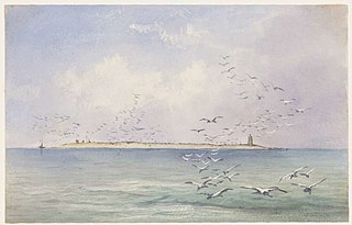
Breton National Wildlife Refuge is located in southeastern Louisiana in the offshore Breton Islands and Chandeleur Islands. It is located in the Gulf of Mexico and is accessible only by boat. The refuge was established in 1904 through executive order of President Theodore Roosevelt and is the second-oldest refuge in the National Wildlife Refuge System.
Sandy Point Island is a 35-acre (14 ha) island in Little Narragansett Bay, lying mostly in Westerly, Rhode Island and partly in Stonington, Connecticut. Once an extension of Napatree Point, Sandy Point is now a one-mile-long (1.6 km) island that serves as an important nature preserve and recreation site. Sandy Point is the westernmost piece of land in the state of Rhode Island.

Green Head is a small Australian coastal town in the Shire of Coorow. The town is situated between Geraldton and Perth in the Mid West region of Western Australia along Indian Ocean Drive. Its beaches and lifestyle provide a relaxed holiday atmosphere. It is the home of what was a significant, but now declining, rock lobster industry.

Deveaux Bank is a horseshoe-shaped sand spit island encompassing a 215-acre (87-hectare) bird sanctuary at the mouth of the North Edisto River in Charleston County, South Carolina. It is located on the Atlantic Coast between Edisto Island, South Carolina and Seabrook Island, South Carolina. Its average elevation is three feet. It has approximately 2.75 miles of sandy beaches on four sides and a tidal dragon on the side facing the mainland.
Isles of Capri is an island community located in unincorporated Collier County, Florida. The isles are a grouping of four mangrove islands that were developed and connected in the 1950s. The isles are connected by Capri Boulevard, and can be accessed from nearby State Route 951. Isles of Capri is located just north of Marco Island.

