
Atahualpa, also Atawallpa (Quechua), Atabalica, Atahuallpa, Atabalipa, was the last effective Incan emperor before his capture and execution during the Spanish conquest.

Santa Ana de los Cuatro Ríos de Cuenca, commonly referred to as Cuenca, is the capital and largest city of the Azuay Province of Ecuador. Cuenca is located in the highlands of Ecuador at about 2,560 metres above sea level, with an urban population of 361,524 and a population of 596,101 in the Cuenca Canton.
Ecuador is a multicultural and multiethnic nation, with the majority of its population is descended from a mixture of both European and Amerindian ancestry. The other 10% of Ecuador's population originate east of the Atlantic Ocean, predominantly from Spain, Italy, Lebanon, France and Germany. Around the Esmeraldas and Chota regions, the African influence would be strong among the small population of Afro-Ecuadorians that account for no more than 10%. Close to 80% of Ecuadorians are Roman Catholic, although the indigenous population blend Christian beliefs with ancient indigenous customs. The racial makeup of Ecuador is 70% mestizo, 7% Amerindian 7%, 12% White, and 11% Black.

Cañar is a province in Ecuador. The capital is Azogues. At the time of census 2010 the province had a population of 225,184. It contains the 16th-century ruins of Ingapirca, the best-known Inca settlement in Ecuador and a product of their conquest of the indigenous Cañari.

Imbabura is a province located in the Andes of northern Ecuador. The capital is Ibarra. The people of the province speak Spanish, and a large portion of the population also speaks the Imbaburan Kichwa variety of the Quechua language.
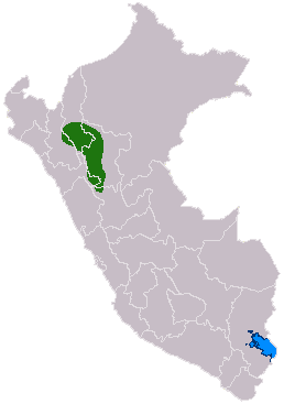
The Chachapoyas, also called the "Warriors of the Clouds", was a culture of the Andes living in the cloud forests of the southern part of the Department of Amazonas of present-day Peru. The Inca Empire conquered their civilization shortly before the Spanish conquest in the 16th century. At the time of the arrival of the conquistadors, the Chachapoyas were one of the many nations ruled by the Incas, although their incorporation had been difficult due to their constant resistance to Inca troops.

Vitcos was a residence of Inca nobles and a ceremonial center of the Neo-Inca State (1537-1572). The archaeological site of ancient Vitcos, called Rosaspata, is in the Vilcabamba District of La Convención Province, Cusco Region in Peru. The ruins are on a ridge overlooking the junction of two small rivers and the village of Pucyura. The Incas had occupied Vilcabamba, the region in which Vitcos is located, about 1450 CE, establishing major centers at Machu Picchu, Choquequirao, Vitcos, and Vilcabamba. Vitcos was often the residence of the rulers of the Neo-Inca state until the Spanish conquest of this last stronghold of the Incas in 1572.

El Fuerte de Samaipata or Fort Samaipata, also known simply as "El Fuerte", is a Pre-Columbian archaeological site and UNESCO World Heritage Site located in Florida Province, Santa Cruz Department, Bolivia. It is situated in the eastern foothills of the Bolivian Andes and is a popular tourist destination for Bolivians and foreigners alike. It is served by the nearby town of Samaipata. The archaeological site at El Fuerte is unique as it encompasses buildings of three different cultures: Chanè, Inca, and Spanish.
Ingapirca is a town in Cañar Province, Ecuador, and the name of the older Inca ruins and archeological site nearby.
Tumebamba, Tomebamba, or Tumipampa was a former main regional city in the Inca Empire. Tumebamba was chosen by the Emperor Huayna Capac to be the Inca northern capital. The city was largely destroyed during the civil war between Huáscar and Atahualpa shortly before the arrival of the Spanish conquistadors in 1532. The Spanish city of Cuenca, Ecuador was built on the site of Tumebamba although a portion of the Inca city is preserved at the archaeological sites of Pumapunku and Todos Santos.

The Cañari are an indigenous ethnic group traditionally inhabiting the territory of the modern provinces of Azuay and Cañar in Ecuador. They are descended from the independent pre-Columbian tribal confederation of the same name. The historic people are particularly noted for their resistance against the Inca Empire. Eventually conquered by the Inca in the early 16th century shortly before the arrival of the Spanish, the Cañari later allied with the Spanish against the Inca. Today, the population of the Cañari, who include many mestizos, numbers in the thousands.

Pre-Columbian Ecuador included numerous indigenous cultures, who thrived for thousands of years before the ascent of the Incan Empire. Las Vegas culture of coastal Ecuador, flourishing between 8000 and 4600 BC, is one of the oldest cultures in the Americas. The subsequent Valdivia culture in the Pacific coast region is another well-known early Ecuadorian culture. Ancient Valdivian artifacts from as early as 3500 BC have been found along the coast north of the Guayas Province in the modern city of Santa Elena.

Bolívar Canton is a canton of Ecuador, located in Carchi Province. Its capital is the town of Bolívar. Its population at the 2001 census was 13,898 and in 2010 was 14,347.

Ibarra Canton is a canton of Ecuador, located in Imbabura Province. Its capital is the town of Ibarra. Its population in the 2001 census was 153,256 and 181,175 in the 2010 census. The area of the canton is 1,137 square kilometres (439 sq mi).
Cochasquí is the "most extensive and most important complex" of pre-Columbian and pre-Inca Empire ruins in northern Ecuador. The site lies some 30 kilometres (19 mi) northeast of Quito in Pedro Moncayo Canton in Pichincha Province at 3,040 metres (9,970 ft) above sea level.
Quispiguanca, also Q'espihuanca and Q'espiwanka, was a royal estate of the Inca emperor Huayna Capac. The ruins of the estate are located in the northern part of the present-day town of Urubamba, Peru at an elevation of 2,910 metres (9,550 ft).

The Saraguro is a people of the Kichwa nation most of whom live in Saraguro Canton in the Loja Province of Ecuador. Although most now speak Spanish, Runashimi or Kichwa, a Quechua dialect, is also spoken and language revitalization efforts are being implemented. Likewise, the Saraguro have retained much of their land, customs and traditional dress. According to the INEC's 2010 population census, the total population of Saraguro canton is 30,183, but that total includes both the Indigenous and non-Indigenous people living in Saraguro.
The Inca-Caranqui archaeological site is located in the village of Caranqui on the southern outskirts of the city of Ibarra, Ecuador. The ruin is located in a fertile valley at an elevation of 2,299 metres (7,543 ft). The region around Caranqui, extending into the present day country of Colombia, was the northernmost outpost of the Inca Empire and the last to be added to the empire before the Spanish conquest of 1533. The archaeological region is also called the Pais Caranqui.
The Pambamarca Fortress Complex consists of the ruins of a large number of pukaras and other constructions of the Inca Empire. The fortresses were constructed in the late 15th century by the Incas to overcome the opposition of the people of the Cayambe chiefdom to the expansion of the Incas in the Andes highlands of present-day northern Ecuador. The Pambamarca fortresses are located in Cayambe Canton in Pichincha Province about 32 kilometres (20 mi) in a straight-line distance northeast of the city of Quito.
Rumicucho or Pucara de Rumicucho is an archaeological site of the Inca Empire in the parroquia of San Antonio de Pichincha, in Quito Canton, Pichincha Province. Ecuador. Rumicucho is a pucara located 23 kilometres (14 mi) in a straight-line distance north of the city of Quito at an elevation of 2,401 metres (7,877 ft). Rumicucho in the Quechua language means "stone corner", perhaps referring to its strategic location between the territory of the Yumbo people to the east and the chiefdoms of the Pais Caranqui to the north.

