
Thomas Moran was an American painter and printmaker of the Hudson River School in New York whose work often featured the Rocky Mountains. Moran and his family, wife Mary Nimmo Moran and daughter Ruth took residence in New York where he obtained work as an artist. He was a younger brother of the noted marine artist Edward Moran, with whom he shared a studio. A talented illustrator and exquisite colorist, Thomas Moran was hired as an illustrator at Scribner's Monthly. During the late 1860s, he was appointed the chief illustrator for the magazine, a position that helped him launch his career as one of the premier painters of the American landscape, in particular, the American West.

The geology of the Zion and Kolob canyons area includes nine known exposed formations, all visible in Zion National Park in the U.S. state of Utah. Together, these formations represent about 150 million years of mostly Mesozoic-aged sedimentation in that part of North America. Part of a super-sequence of rock units called the Grand Staircase, the formations exposed in the Zion and Kolob area were deposited in several different environments that range from the warm shallow seas of the Kaibab and Moenkopi formations, streams and lakes of the Chinle, Moenave, and Kayenta formations to the large deserts of the Navajo and Temple Cap formations and dry near shore environments of the Carmel Formation.

Zion Canyon is a deep and narrow gorge in southwestern Utah, United States, carved by the North Fork of the Virgin River. Nearly the entire canyon is located within the western half of Zion National Park.
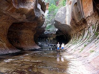
The Subway is a small, uniquely-shaped slot canyon within the Zion Wilderness in Zion National Park in northeastern Washington County, Utah, United States. The National Park Service limits access to the canyon via a permit system.

Mount Carmel Junction and Mount Carmel are unincorporated communities located 12 miles (19 km) east of Zion National Park and 17 miles (27 km) north of Kanab in Kane County, Utah, United States. They lie in close proximity to the Coral Pink Sand Dunes State Park.

The Mount Trumbull Wilderness is a 7,880 acre (31 km2) wilderness area located on the Uinkaret Plateau in the Arizona Strip. It is managed by the Bureau of Land Management.
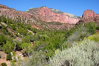
Horse Ranch Mountain is an 8,733-foot (2,662 m) mountain in the Kolob Canyons section of Zion National Park in northeastern Washington County, Utah, United States, that is the highest summit within the national park. It rises above Camp Creek to the north and Taylor Creek to the south. Its neighbors include Tucupit Point, 1 mi (1.6 km) to the south, and Timber Top Mountain is situated 3.9 mi (6.3 km) to the south-southwest.
Zion National Park is an American national park located in southwestern Utah near the town of Springdale. Located at the junction of the Colorado Plateau, Great Basin, and Mojave Desert regions, the park has a unique geography and a variety of life zones that allow for unusual plant and animal diversity. Numerous plant species as well as 289 species of birds, 75 mammals, and 32 reptiles inhabit the park's four life zones: desert, riparian, woodland, and coniferous forest. Zion National Park includes mountains, canyons, buttes, mesas, monoliths, rivers, slot canyons, and natural arches. The lowest point in the park is 3,666 ft (1,117 m) at Coalpits Wash and the highest peak is 8,726 ft (2,660 m) at Horse Ranch Mountain. A prominent feature of the 229-square-mile (590 km2) park is Zion Canyon, which is 15 miles (24 km) long and up to 2,640 ft (800 m) deep. The canyon walls are reddish and tan-colored Navajo Sandstone eroded by the North Fork of the Virgin River.

The Hurricane Cliffs of southwest Utah and northwest Arizona are a red, limestone geographic feature, sets of cliffs along the western, eroded edge of the Kaibab Limestone; the cliffs are about 135-mi (217 km) long, with the south end terminus just north of the Grand Canyon. The cliffs are associated with the Hurricane Fault.

The East Temple is a prominent 7,709 feet (2,350 m) summit composed of Navajo Sandstone in Zion National Park, in Washington County of southwest Utah, United States. It is one of the notable landmarks in the park. The nearest neighbor is Twin Brothers, one-half mile to the north, and the nearest higher peak is The West Temple, 3.85 miles (6.20 km) to the west-southwest. The mountain is situated 1.8 miles northeast of the park headquarters, at the confluence of Pine Creek and the North Fork Virgin River. This feature's name was applied by John Wesley Powell during his explorations in 1872, and was officially adopted in 1934 by the U.S. Board on Geographic Names. The first ascent was made in 1937 by Glen Dawson, Dick Jones, Homer Fuller, Wayland Gilbert, and Jo Momyer.

The West Temple is a prominent 7,810-foot mountain summit composed of Navajo Sandstone in Zion National Park in Washington County of Utah, United States. This, the highest feature in Zion Canyon, was originally called "Temp-o-i-tin-car-ur" meaning "Mountain without a trail" by the Paiute people. It was called Steamboat Mountain by local Mormon settlers before 1934, when the USGS officially changed it to its present name, which was applied by John Wesley Powell during his explorations in 1872. West Temple is situated two miles northwest of Springdale, Utah, one mile northeast of Mount Kinesava, and two miles west of the park headquarters. It is one of the notable landmarks in the park. The nearest higher peak is Windy Peak, 10.46 miles (16.83 km) to the north. Precipitation runoff from the mountain drains into tributaries of the Virgin River.

Tucupit Point is a prominent sandstone pinnacle in the Kolob Canyons area of Zion National Park in Washington County, Utah, United States.
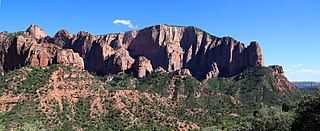
Timber Top Mountain is an 8,055-foot (2,455 m) mountain summit located in the Kolob Canyons section of Zion National Park, in Washington County, Utah, United States. Its nearest higher neighbor is Horse Ranch Mountain, 3.9 mi (6.3 km) to the north-northeast, Nagunt Mesa is immediately north, and Tucupit Point is situated 2.8 mi (4.5 km) to the north. Timber Top Mountain is the second-highest peak in Zion Park, following only Horse Ranch Mountain. Walls of Navajo sandstone encircle this mesa-like feature, ranging from 400-ft high on along the south side, up to 2,000 feet on the north aspect. Kolob Arch is set on the lower southeast cliff of the mountain, and Shuntavi Butte forms the west tip of the mountain. Precipitation runoff from the mountain drains into Timber Creek, which is within the Virgin River drainage basin.

Nagunt Mesa is a 7,785-foot (2,373 m) mountain summit located in the Kolob Canyons area of Zion National Park in Washington County, Utah, United States.

Mountain of Mystery is a 6,565-foot (2,001 m) Navajo Sandstone summit located in Zion National Park, in Washington County of southwest Utah, United States. Mountain of Mystery is situated above The Narrows, towering over 2,100 feet above the floor of Zion Canyon and the North Fork Virgin River which drains precipitation runoff from this mountain. This peak rises above Orderville Canyon on its north side, and Mystery Canyon on the south. Its neighbors include Mount Majestic, Cathedral Mountain, Observation Point, Cable Mountain, Angels Landing, and The Organ. This feature's name was officially adopted in 1934 by the U.S. Board on Geographic Names. The first ascent via the Northeast Buttress was made 15 September 2001, by Brian Cabe and Tom Jones.

Paria Point is a 7,802-foot (2,378 m) elevation summit located in the Kolob Canyons section of Zion National Park, in Washington County, Utah, United States. Tucupit Point is situated 0.5 mi (0.80 km) immediately north, and Beatty Point is 0.5 mi (0.80 km) immediately south, with 2,000-foot-deep finger canyons between each. Other neighbors include Nagunt Mesa and Timber Top Mountain to the south, and Horse Ranch Mountain to the north. Paria Point is composed of Jurassic Navajo sandstone overlaying tilted Kayenta Formation. Precipitation runoff drains into Taylor Creek, which is part of the Virgin River drainage basin. This feature's paria name is a Paiute word meaning "muddy water" or "elk water".

Beatty Point is a 7,780-foot (2,370 m) elevation summit located in the Kolob Canyons area of Zion National Park in Washington County, Utah, United States.

Smithsonian Butte is a 6,780-foot (2,070 m) elevation summit located in the Canaan Mountain Wilderness of Washington County in southwest Utah, United States.

Newberry Butte is a 5,105-foot-elevation (1,556-meter) summit located in the Grand Canyon, in Coconino County of northern Arizona, US. It is situated 4.5 miles north of the South Rim's Grandview Point, three miles southwest of Vishnu Temple, and 2.5 miles south of Wotans Throne. Topographic relief is significant as it rises over 2,500 feet above the Colorado River and Granite Gorge in one mile. According to the Köppen climate classification system, Newberry Butte is located in a Cold semi-arid climate zone.

The Three Patriarchs is a set of three sandstone monoliths on the west side of Zion Canyon in Zion National Park in Washington County, Utah, United States. The three main peaks were named by Frederick Fisher in 1916 for the biblical figures Abraham, Isaac and Jacob. The Court of the Patriarchs is the cliff that runs along the south face of the Three Partiarchs.
