This article may be expanded with text translated from the corresponding article in Cebuano. (March 2021)Click [show] for important translation instructions.
|
Collingwood Bay is a bay on the coast of Oro Province, Papua New Guinea.
This article may be expanded with text translated from the corresponding article in Cebuano. (March 2021)Click [show] for important translation instructions.
|
Collingwood Bay is a bay on the coast of Oro Province, Papua New Guinea.
Coordinates: 9°20′S149°20′E / 9.333°S 149.333°E
| | This Papua New Guinea–related geography article is a stub. You can help Wikipedia by expanding it. |

Kelly Basin is a bay on the south eastern side of Macquarie Harbour on the West Coast of Tasmania.

The Northumberland Islands are a scattered island chain off the eastern coast of Queensland, Australia.

Carmila is a rural town and coastal locality in the Isaac Region, Queensland, Australia. In the 2016 census, the locality of Carmila had a population of 333 people.
Limon Bay is a natural harbor located at the north end of the Panama Canal, west of the cities of Cristóbal and Colón. Ships waiting to enter the canal stay here, protected from storms by breakwaters.

Utstikkar Glacier is a broad glacier flowing north from the vicinity of Moyes Peak in Antarctica and terminating in Utstikkar Glacier Tongue between Utstikkar Bay to the east and Allison Bay to the west. The glacier was mapped and named Utstikkarbreen by Norwegian cartographers working from aerial photographs taken by the Lars Christensen Expedition in January–February 1937.
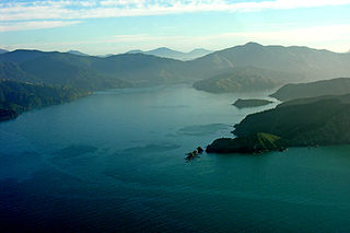
Te Whanganui / Port Underwood is a sheltered harbour which forms the north-east extension of Cloudy Bay at the northeast of New Zealand's South Island, on the east coast of the Marlborough Sounds. With only a relatively narrow entrance to the south-south-east it is sheltered from almost all winds. Originally considered part of Cloudy Bay the port was named after Joseph Underwood of the shipping firm Kabel and Underwood in the early 19th century.

Shambles Glacier is a steep glacier 4 miles (6 km) long and 6 miles (10 km) wide, with very prominent hummocks and crevasses, flowing east between Mount Bouvier and Mount Mangin into Stonehouse Bay on the east side of Adelaide Island. It is the island's largest glacier, and provides an eastern outlet from the giant Fuchs Ice Piedmont which covers the entire western two-thirds of the island. In doing so, Shambles Glacier provides the largest 'gap' in Adelaide Island's north–south running mountain chain.
Albrecht Penck Glacier is a glacier between the Fry Glacier and the Evans Piedmont Glacier, draining northeast toward Tripp Bay on the coast of Victoria Land, Antarctica. It was first charted by the British Antarctic Expedition (1907–09) which named this feature for Albrecht Penck, the Director of the Institute of Oceanography and of the Geographical Institute in Berlin.
The Merrica River is an intermediate intermittently closed saline coastal lagoon or perennial river located in the South Coast region of New South Wales, Australia.
Woodbury Glacier is a glacier just west of Montgolfier Glacier, flowing into Piccard Cove, Wilhelmina Bay, on the west coast of Graham Land. Mapped by the Falkland Islands Dependencies Survey (FIDS) from air photos taken by Hunting Aerosurveys Ltd. in 1956–57. Named by the United Kingdom Antarctic Place-Names Committee (UK-APC) in 1960 for Walter B. Woodbury (1834–1885), English pioneer of photomechanical printing in 1865 and of serial film cameras for use in balloons and kites in 1877.
Comrie Glacier is a glacier 13 nautical miles (24 km) long, flowing west to enter the head of Bigo Bay on the west coast of Graham Land. It was first sighted and roughly surveyed by the French Antarctic Expedition in 1909. It was resurveyed in 1935–36 by the British Graham Land Expedition (BGLE), and later named for Leslie J. Comrie, founder and first Director of the Scientific Computing Service Ltd, London, who, as Superintendent of HM Nautical Almanac Office in 1934, greatly assisted the BGLE, 1934–37, by providing advance copies of The Nautical Almanac up to 1937.

Coulter Glacier is a steeply inclined glacier, 5 nautical miles (9 km) long, flowing south from the Havre Mountains, northern Alexander Island, into Kolokita Cove in Lazarev Bay, Antarctica. The glacier was photographed from the air by the Ronne Antarctic Research Expedition in 1947 and mapped from the photographs by the Falkland Islands Dependencies Survey in 1960. It was named by the Advisory Committee on Antarctic Names for R.W. Coulter, Master of USNS Alatna during U.S. Navy Operation Deepfreeze, 1969.

Trooz Glacier is an Antarctic glacier. Situated on the Kyiv Peninsula in Graham Land, 1.5 nautical miles (2.8 km) wide at its mouth and some 15 nautical miles (28 km) long, it flows west into the north part of Collins Bay. It was Discovered by the French Antarctic Expedition, 1908–10 and Named for J. de Trooz, Belgian Minister of the Interior and Public Instruction, who was instrumental in procuring funds for the publication of the scientific results of the Belgian Antarctic Expedition, 1897–99. This application was suggested by the Advisory Committee on Antarctic Names (US-ACAN) because of duplication of the name Trooz for what is now known as Cape Perez.

The Marshall Archipelago is an extensive group of large ice-covered islands within the Sulzberger Ice Shelf off Antarctica. Several of the islands were discovered and plotted by the Byrd Antarctic Expeditions and by the United States Antarctic Service (1939–41), all led by Admiral Richard E. Byrd. The full extent of the archipelago was mapped by the United States Geological Survey from surveys and U.S. Navy air photos (1959–65). The name was proposed by Admiral Byrd for General of the Army George C. Marshall, who made financial contributions as a private individual and also, on the same basis, provided advisory assistance to the Byrd expedition of 1933–35.

Russell East Glacier is a glacier, 6 nautical miles (11 km) long and 3 nautical miles (6 km) wide, which lies at the north end of Detroit Plateau and flows from Mount Canicula and Verdikal Gap along the south slopes of Erul Heights eastward into Smokinya Cove in Prince Gustav Channel on the south side of Trinity Peninsula. This glacier together with Russell West Glacier, which flows westward into Bone Bay on the north side of Trinity Peninsula, form a through glacier across the north part of Antarctic Peninsula. It was first surveyed in 1946 by the Falkland Islands Dependencies Survey (FIDS). Named by the United Kingdom Antarctic Place-Names Committee (UK-APC) for V.I. Russell, surveyor and leader of the FIDS base at Hope Bay in 1946.
Crossing Creek is a creek in north west New South Wales, Australia that flows into Tycannah Creek. It begins at an elevation of 480m above sea level, and falls 141m to 338m above sea level along its 14.3 km length.
Yowrie River, a perennial river of the Tuross River catchment, is located in the upper ranges of the South Coast region of New South Wales, Australia.

The Leap is a coastal rural locality in the Mackay Region, Queensland, Australia. In the 2016 census The Leap had a population of 642 people.
The Back River, a perennial stream of the Tuross River catchment, is located in the Monaro and South Coast regions of New South Wales, Australia.
Bucasia is a coastal town and one of the largest suburb of Mackay in the Mackay Region, Queensland, Australia. In the 2016 census the suburb of Bucasia had a population of 4,771 people.