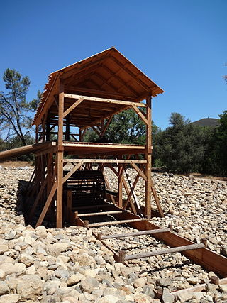
Sutter's Mill was a water-powered sawmill on the bank of the South Fork American River in the foothills of the Sierra Nevada in California. It was named after its owner John Sutter. A worker constructing the mill, James W. Marshall, found gold there in 1848. This discovery set off the California Gold Rush (1848–1855), a major event in the history of the United States.

Sutter's Fort was a 19th-century agricultural and trade colony in the Mexican Alta California province. Established in 1839, the site of the fort was originally called New Helvetia by its builder John Sutter, though construction of the fort proper would not begin until 1841. The fort was the first non-indigenous community in the California Central Valley. The fort is famous for its association with the Donner Party, the California Gold Rush, and the formation of the city of Sacramento, surrounding the fort. It is notable for its proximity to the end of the California Trail and Siskiyou Trails, which it served as a waystation.

Placerville is a city in and the county seat of El Dorado County, California. The population was 10,747 as of the 2020 census, up from 10,389 as of the 2010 census. It is part of the Sacramento–Arden-Arcade–Roseville Metropolitan Statistical Area.
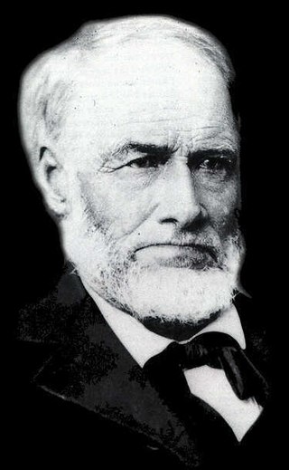
James Wilson Marshall was an American carpenter and sawmill operator, who on January 24, 1848, reported the finding of gold at Coloma, California, a small settlement on the American River about 36 miles northeast of Sacramento. His discovery was the impetus for the California Gold Rush. The mill property was owned by Johann (John) Sutter who employed Marshall to build his mill. The wave of gold seekers turned everyone's attention away from the mill which eventually fell into disrepair and was never used as intended. Neither Marshall nor Sutter ever profited from the gold find.

The Native Sons of the Golden West (NSGW) is a fraternal service organization founded in the U.S. state of California in 1875, dedicated to historic preservation and documentation of the state's historic structures and places, the placement of historic plaques, and other charitable functions in California. In 1890 the organization placed California's first marker honoring the discovery of gold, which gave rise to the state nickname, "The Golden State". U.S. President Richard M. Nixon and Chief Justice Earl Warren served terms as presidents of the NSGW.
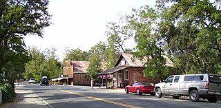
Coloma is a census-designated place in El Dorado County, California, US. It is approximately 36 miles (58 km) northeast of Sacramento, California. Coloma is most noted for being the site where James W. Marshall found gold in the Sierra Nevada foothills, at Sutter's Mill on January 24, 1848, leading to the California Gold Rush. Coloma's population is 529.

State Route 49 is a north–south state highway in the U.S. state of California that passes through many historic mining communities of the 1849 California gold rush and it is known as the Golden Chain Highway. The highway's creation was lobbied by the Mother Lode Highway Association, a group of locals and historians seeking a single highway to connect many relevant locations along the Gold Rush to honor the 49ers. One of the bridges along SR 49 is named for the leader of the association, Archie Stevenot.

A California Historical Landmark (CHL) is a building, structure, site, or place in the U.S. state of California that has been determined to have statewide historical landmark significance.

Marshall Gold Discovery State Historic Park is a state park of California, United States, marking the discovery of gold by James W. Marshall at Sutter's Mill in 1848, sparking the California Gold Rush. The park grounds include much of the historic town of Coloma, California, which is now considered a ghost town as well as a National Historic Landmark District. The park contains thre California Historical Landmarks: a monument to commemorate James Marshall (#143), the actual spot where he first discovered gold in 1848 (#530). Established in 1942, and Coloma Road (#748),. The park now comprises 576 acres (233 ha) in El Dorado County.
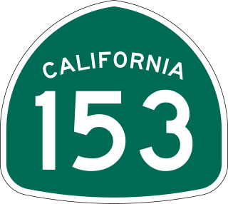
State Route 153 is a very short state highway in the U.S. state of California in El Dorado County. It extends only 0.5 miles (0.80 km) from the junction of Cold Springs Road and SR 49, in the town of Coloma in the heart of California's Gold Country, to the monument marking the grave of James Marshall, whose finding of gold along the American River, January 24, 1848 sparked the California Gold Rush. The exact routing is from SR 49 south on Cold Springs Road then west on Monument Road in Marshall Gold Discovery State Historic Park to the monument.

El Dorado is an unincorporated community in El Dorado County, California. It is located 4 miles (6.4 km) southwest of Placerville, at an elevation of 1608 feet. The population was 4,096 at the 2000 census. The town is registered as California Historical Landmark #486. The ZIP code is 95623. The community is inside area code 530.

Mormon Island was once a mining town, which had an abundance of Mormon immigrants seeking gold in the American River during the California Gold Rush. Its site is in present-day Sacramento County, California.
Lotus is an unincorporated community in El Dorado County, California, United States. It is located 1 mile (1.6 km) west of Coloma, at an elevation of 722 feet.
Rescue, formerly Green Valley, El Dorado County, California, is an unincorporated community in El Dorado County, California. It is located north-northwest of Shingle Springs and north-northeast of Cameron Park. The zip code is 95672, and Rescue is located in area code 530. The town lies at an elevation of 1214 feet.
Condemned Bar is a former settlement, in El Dorado County, California. It is in the Sierra Nevada foothills. The former town is now under Folsom Lake. A Historical Landmark marker was built at Folsom Lake State Recreation Area. The former mining town of the California Gold Rush is registered as California Historical Landmark #572.
Garden Valley is an unincorporated community in El Dorado County, California. It is located on Johntown Creek 6.25 miles (10 km) north-northwest of Chili Bar, at an elevation of 1949 feet.
Greenwood is an unincorporated community in El Dorado County, California. It is located 4 miles (6.4 km) west of Georgetown, at an elevation of 1608 feet.
Marshall's Blacksmith Shop is a California Historical Landmark No. 319, now on the private property in Kelsey, California. The Blacksmith Shop was built in 1872 off of what is now California State Route 193 in El Dorado County, California at Gray Eagle Mine. James W. Marshall was a Blacksmith, a carpenter and sawmill operator. The Gray Eagle mine and ore mill is a lode gold mine on 13.2 acres of land in the Mother Lode Country, just south of Kelsey. Marshall was part owner of the Gray Eagle mine.
Methodist Episcopal Church in Placerville, California is a California Historical Landmark No. 767. The Methodist Episcopal Church was built in 1851 in El Dorado County, California. Methodist Episcopal Church is the oldest church building in El Dorado County. The Church building was moved to its current location from its original site on the corner of Cedar Ravine and Main Street, Placerville 38.7287°N 120.796°W. The roof support beams were hand-made from local ponderosa pine trees. Methodist Episcopal Church's first bell tower bell was purchased from the sailing ship Staffordshire. A historical marker was placed and dedicated by the El Dorado County Chamber of Commerce in 1961 and re-dedicated in 1996.

Pleasant Grove House Pony Express Station is a historical building in Rescue, California built in 1850. The site of the Pleasant Grove House Pony Express Station is a California Historical Landmark No. 703. The historical building was built to house California Gold Rush 49 miners traveling to find gold and stake a claim. The Pleasant Grove House Pony Express Station in El Dorado County, California. At the Pleasant Grove House Pony Express Station, Pony Express riders would change horses. The Pleasant Grove House Pony Express Station was used for the Central Overland California and Pikes Peak Express Company's Pony Express Service from July 1, 1860, to June 30, 1861. From the Pleasant Grove House Pony Express Station, the riders heading west would go to Folsom. Riders heading east rode to Placerville traveling through the Rescue, Dry Creek Crossing, and Missouri Flat.

