Colonial Lake is a tidal pond in Charleston, South Carolina with wide walkways around it. The area is used as a park. For many years the lake was known as the Rutledge Street Pond; some residents still call it "The Pond." It acquired the name Colonial Lake in 1881, in honor of the "Colonial Commons" established in 1768.
History
This 1909 postcard image shows the houses along Rutledge Ave., viewed across Colonial Lake from Beaufain St.
The lake and its park were part of the Commons established by an Act of the Commons House of Assembly in 1768, setting aside the area forever for public use.[1] Plans for a pond and park were developed by 1869.[2] The actual lake was created by 1873 when Lynch St. (now Ashley Ave.) was extended south to Broad St., enclosing the area now occupied by the lake.[3]
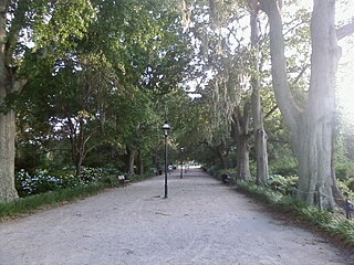
Before the Parks Conservancy plans were implemented, the area surrounding the lake (shown here in 2014) was largely just grass.
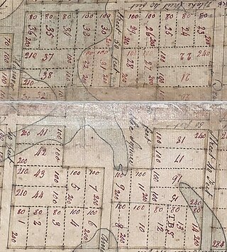
As seen in the 1872 Bird's Eye View of Charleston, the northwest corner of Colonial Lake originally was land that was possible to develop with a few houses. In 1874, the houses were removed so that improvements to Colonial Lake could continue.[4]
In 1875, a local mill owner, Patrick P. Toale, received a lease for some of the land surrounding the lake. When he tried to purchase the property, local citizens strongly opposed the request and filed a lawsuit to prevent the deal. Judge J.B. Kershaw sided with the opponents, ordering that all remaining property held by the city be retained for the benefit of all Charlestonians and that a commission be created to oversee the property.[5]
In 1881, a court reconfirmed that all of the subject land not already sold would remain in the public trust. The court ordered that the City Council create a commission to accept control of the land and its funding. The commission was to receive the rents from the public lands which would be used to maintain the public property and to possibly reacquire land southward to Tradd St. between Ashley and Rutledge Aves. In response to the order of the court, City Council created the Commissioners of the Colonial Common and Ashley River Embankment.[1]
The park around the lake was developed in the 1880s. In 1882, the Commissioners of the Public Common decided to formalize the popular site by installing concrete walls and walks around it with a park on the north side.[6] The current configuration of a lake within concrete embankments with a wide promenade on all four sides was largely completed by 1885.[7]
"Gala Week" used to be held in the fall of the year, with a fireworks display on the west side of the Pond,[8] which was then an undeveloped area. Spectators filled to park and crowded onto boats in the lake.[9] Boats were a popular feature of Colonial Lake, and the city even began requiring licenses for them to maintain order on the pond in 1910.[10] Starting that same year, a series of boat and "tub" races were staged in the lake for local boys with money awarded to the winners.[11] For a time, the lake was closed off from the Ashley River with a wire screen and stocked with fish for recreational fishing.[12]
By 1872, when the Bird's Eye View Map of Charleston was drawn, Ashley Ave. (then known as Lynch St.) had been completed, forming the western edge of Colonial Lake.
Improvements to the park have been consistent. In 1902, the promenade was improved with a stone pavement. Other improvements were considered, but the lack of security at the site caused officials to question the idea.[13] A dedicated police officer was assigned in 1904.[14] In 1910, palmetto trees were planted along Ashley Ave. and more extensive landscaping was carried out, but officials again noted that vandalism by children playing in the area was causing problems.[15] In 1911, the commissioners who oversaw Colonial Lake announced that new benches would be installed and forty water oaks would be planted.[16] In 1938, the leader of a local club proposed installing a man-made island in the center of the lake, stocking the lake with salt water fish, and promoting it as a destination for visitors; the plan was opposed by residents and did not take place.[17] In 1972, fountains were installed to aerate the lake, but neighbors complained about saltwater overspray, and the fountains often idled due to low water and rusted parts; in 1977, they were removed.[18]
The Charleston Parks Conservancy, a nonprofit founded in 2007, announced plans to renovate Colonial Lake in 2008. Its plans would have narrowed adjacent Rutledge Ave. by nine feet (to the same width as nearby streets) and installed a more formal landscape around the lake.[19] Plans were completed with some modifications, and an expected January 2015 start date for the four million dollar project was set. Work is expected to be completed in early 2016.[20]
Notes
1 2 "The Work of City Council". News and Courier. Charleston, South Carolina. July 27, 1881. p.1.
↑ "That Park and Pond". News and Courier. Charleston, South Carolina. August 19, 1869. p.1.
↑ "The Rutledge Street Pond Race". News and Courier. Charleston, South Carolina. September 4, 1873. p.4.
↑ News and Courier. June 25, 1874. p.4.{{cite news}}: Missing or empty |title= (help)
St. Michael's AnglicanChurch is a historic church and the oldest surviving religious structure in Charleston, South Carolina. It is located at Broad and Meeting streets on one of the Four Corners of Law, and represents ecclesiastical law. It was built in the 1750s by order of the South Carolina Assembly. It is listed on the National Register of Historic Places and is a National Historic Landmark.
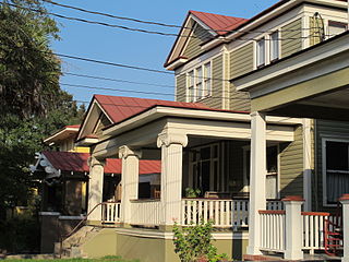
Hampton Park Terrace is the name both of a neighborhood and a National Register district located in peninsular Charleston, South Carolina. The neighborhood is bounded on the west by The Citadel, on the north by Hampton Park, on the east by Rutledge Ave., and on the south by Congress St. In addition, the one block of Parkwood Ave. south of Congress St. is considered, by some, to be included. The National Register district, on the other hand, is composed of the same area with two exceptions: (1) the northeasternmost block is excluded and (2) an extra block of President St. is included.
Charles Towne Landing State Historic Site in the West Ashley area of Charleston, South Carolina preserves the original site of the first permanent English settlement in Carolina. Originally opened in 1970 to commemorate South Carolina's tricentennial, this 664-acre (269 ha) site is home to an exhibit hall, rental facility, a natural habitat zoo, ongoing archeological excavations, miles of trails, dozens of picnic tables, a replica tall ship, six fireable replica cannon, and much more.
Hampton Park is a public park located in peninsular Charleston, South Carolina, United States. At 60 acres (240,000 m2), it is the largest park on the peninsula. It is bordered by The Citadel to the west, Hampton Park Terrace to the south, North Central to the east, and Wagener Terrace to the north. The park is named in honor of Confederate General Wade Hampton III who, at the time of the Civil War, owned one of the largest collections of slaves in the South. After the Civil War, Hampton became a proponent of the Lost Cause movement, member of the Red Shirts and governor of South Carolina.
Christopher W. Werner (1805–1875) was a nineteenth-century wrought iron manufacturer, artisan, and entrepreneur based in Charleston, South Carolina, US. He was one of three noted German-American ironworkers in Charleston, who created most of its high-quality wrought iron. He had immigrated from Prussia in his late 20s, already an accomplished businessman. In Charleston he married a young woman from England, another immigrant, and they had a family.
Albert Wheeler Todd was an architect in Charleston, South Carolina. He is known for his neoclassical architecture, the design on his own home and of a home for Tristram Hyde. Todd was the senior partner at the firm of Todd & Benson which became Todd, Simons & Todd. Joseph F. Leitner worked with him. Todd also served in the legislature from 1910 until 1924 and was a State Senator.
John Darlington Newcomer was an American architect whose practice focused on Charleston, South Carolina in the early 20th century.
Brittlebank Park is a ten-acre park located between Lockwood Boulevard and the Ashley River in Charleston, South Carolina near Gadsden Creek. To the south is a condominium project and to the north is the minor league baseball stadium, the Joseph P. Riley Jr. Park.
Cannon Park is a 2.7 acre public park located in peninsular Charleston, South Carolina. It is bound to the north by Calhoun St. and to the south by Bennett St. To the east and west are Rutledge Ave. and Ashley Ave. respectively.
Moultrie Playground is a public park in Charleston, South Carolina.
Mitchell Playground is a public park in Charleston, South Carolina bounded by Fishburne St. (north), Perry St. (east), Sheppard St. (south), and Rutledge Ave. (west). It is named for the Julian Mitchell Elementary School to the immediate east of the playground.
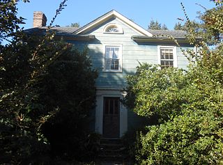
The James Nicholson House is a notable early 19th-century residence in Charleston, South Carolina which has housed the Ashley Hall school since 1909. The house was built ca. 1816 for Patrick Duncan. The architect for the house is not known, but authorities cite William Jay as its possible designer; he worked in Charleston and Savannah between 1817 and 1822. James Nicholson owned the property from 1829 to 1838 when James R. Pringle bought it; after Pringle's death, his family sold it in 1845 to Secretary of the Confederate Treasury General George Trenholm. From 1877 to 1909, it was the home of Charles Otto Witte's family, the foremost banker in South Carolina. Many characters in Margaret Mitchell's Gone with the Wind novel, including Rhett Butler, were based upon residents of this historic homestead, and the O'Hara plantation itself was modeled on its grounds.
Corrine Jones Playground was formerly known as Hester Park because of its location along Hester Street in Charleston, South Carolina. The playground is located on a portion of the larger Buist Tract that had been used during World War II as housing for the influx of wartime workers.
Broad Street is a street in Charleston, South Carolina. It is known for its wealth of historic resources as well as being on the American Planning Association (APA)'s list of "great streets". Broad Street is characterized by its historic architecture maintained through a history of persistent and scrupulous historic preservation. Broad Street today is a mix of residences, historic buildings, public uses, as well as restaurants and nightlife uses.
Augustus E. Constantine was an architect in Charleston, South Carolina. He is known for his Art Moderne architecture.
The Ashley House, one of the tallest buildings in Charleston, South Carolina is a fourteen-story condominium building on Lockwood Blvd. in Charleston, South Carolina. When built, it was the tallest apartment building in the city.
Henry Whilden Lockwood was the fifty-fifth mayor of Charleston, South Carolina, serving between 1938 and 1944.
Stephen Thomas was an architect who practiced mainly in Charleston, South Carolina for about 27 years.
Wagener Terrace in Charleston, South Carolina is a large neighborhood made property that had been owned by Louis Dunnemann and Capt. F.W. Wagener.
Hampstead Mall is a public park in Charleston, South Carolina, of 140,625 square feet in the Hampstead Village neighborhood at the intersection of Columbus and America Streets.
This page is based on this Wikipedia article Text is available under the CC BY-SA 4.0 license; additional terms may apply. Images, videos and audio are available under their respective licenses.