Nicollet Avenue is a major street in Minneapolis, Richfield, Bloomington, and Burnsville, Minnesota. It passes through a number of locally well-known neighborhoods and districts, notably Eat Street in south Minneapolis and the traffic-restricted Nicollet Mall in the city's downtown.
The St. Louis Car Company was a major United States manufacturer of railroad passenger cars, streetcars, trolleybuses and locomotives that existed from 1887 to 1974, based in St. Louis, Missouri.
The Chicago City Railway Company (CCRy) was an urban transit company that operated horse, cable, and electric streetcars on Chicago's South Side between 1859 and 1914, when it became merged into and part of the Chicago Surface Lines (CSL) metropolitan-wide system. After that time it owned electric streetcars, along with gasoline, diesel, and propane - fueled transit busses. Purchased by the government agency Chicago Transit Authority (CTA) in 1947, it was liquidated in 1950.
The Market Street Railway Company was a commercial streetcar and bus operator in San Francisco. The company was named after the famous Market Street of that city, which formed the core of its transportation network. Over the years, the company was also known as the Market Street Railroad Company, the Market Street Cable Railway Company and the United Railroads of San Francisco.

For just under 100 years, between 1862 and 1962, streetcars in Washington, D.C. transported people across the city and region.

The Denver Tramway, operating in Denver, Colorado, was a streetcar system incorporated in 1886. The tramway was unusual for a number of reasons: the term "tramway" is generally not used in the United States, and it is not known why the company was named as such. The track was 3 ft 6 in narrow gauge, an unusual gauge in the United States, but in general use by railways in Japan, southern Africa, New Zealand, and Queensland, Australia.

The Chicago Surface Lines (CSL) was operator of the street railway system of Chicago, Illinois, from the years 1913 to 1947. The firm is a predecessor of today's publicly owned operator, the Chicago Transit Authority.
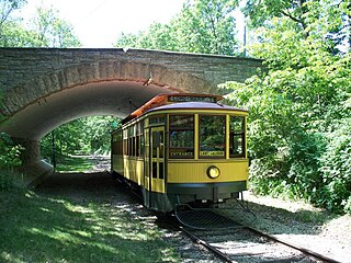
The Minnesota Streetcar Museum (MSM) is a transport museum that operates two heritage streetcar lines in Minneapolis, Minnesota and the western suburb of Excelsior.

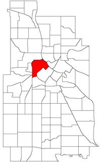
The Central community in Minneapolis is located in the central part of the city, consisting of 6 smaller official neighborhoods, and includes Downtown Minneapolis, the central business district. It also includes some high-density residential areas surrounding it, excluding areas east of the Mississippi River. Businesses based in the Central area include the corporate headquarters of Target, US Bank, and the broadcast facilities of Minnesota CBS station WCCO-TV.
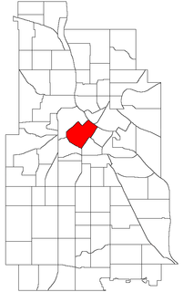
Downtown West is an official neighborhood in Minneapolis, part of the larger Central community. It is the heart of downtown Minneapolis, containing the bulk of high-rise office buildings in the city, and is what comes to mind when most Minneapolitans think of "downtown". Its boundaries are as follows : 12th Street to the southwest, 3rd Avenue North, Washington Avenue North, and Hennepin Avenue to the northwest, the Mississippi River to the northeast, and Portland Avenue, 5th Street South, and 5th Avenue South to the southeast. It is bordered by the North Loop, Nicollet Island/East Bank, Downtown East, Elliot Park, and Loring Park neighborhoods. Downtown West is home to most of Minneapolis's most notable buildings like the Foshay Tower and IDS Center. Being next to the neighborhood Loring Park which has a substantial population of gay people, it is unsurprising that Downtown West has a few gay bars such as The Saloon.

Bottineau is a neighborhood in the Northeast community in Minneapolis.
The Capital Traction Company was the smaller of the two major street railway companies in Washington, D.C. in the early 20th Century. It was formed through a merger of the Rock Creek Railway and the Washington and Georgetown Railroad Company in 1895. The company ran streetcars from Georgetown; Capitol Hill; Chevy Chase, MD; the Armory and Mt. Pleasant. In 1933 it merged with its major competitor the Washington Railway and Electric Company to form the Capital Transit Company.

The Minneapolis Great Northern Depot, also known as Great Northern Station, was a passenger railroad station which served Minneapolis, Minnesota, USA. It was built in 1913 and demolished in 1978. It was located on Hennepin Avenue next to the Hennepin Avenue Bridge and across the street from the main Minneapolis Post Office.
The Mount Hood Railway and Power Company, also known as the Mount Hood Company, initiated hydroelectric development in the Sandy River basin in the U.S. state of Oregon in 1906. Its Bull Run Hydroelectric Project included a powerhouse on the Bull Run River, a tributary of the Sandy River, and a diversion dam on the Little Sandy River, a tributary of the Bull Run River. Water from the dam, which was about 16 feet (4.9 m) high, flowed through a wooden flume about 17,000 feet (5,200 m) long to Roslyn Lake and from there to the powerhouse. The company began using the powerhouse to generate electricity in 1912.
The San Francisco and San Mateo Electric Railway (SF&SM) was the first electric streetcar company in San Francisco, California. The company was only in business for ten years, starting in 1892 until its merger into the United Railroads of San Francisco (URR).
Ottawa Electric Railway Company was a streetcar public transit system in the city of Ottawa, Canada, part of the electric railway streetcars that operated between 1891 and 1959. Ottawa once had tracks through downtown on Rideau Street, Sparks Street and others, and extended outside of the downtown core to provide services that helped form communities such as Westboro, Old Ottawa South and The Glebe. Prior to this, starting in 1866, public transportation was provided by Ottawa City Passenger Railway Company, a horse-drawn tram service. The O.E.R. was taken over by the Ottawa Transportation Commission in 1948, which was itself succeeded by OC Transpo in 1973.

The William and Anita Newman Library is the main library for the students and faculty of Baruch College, a campus of the City University of New York. It is located within the Information and Technology Building or Newman Library and Technology Center, at 151 East 25th Street in Rose Hill, Manhattan, New York City.

The Conductor's Building is a former Boston Elevated Railway (BERy) administrative building, located on Bennett Alley between Mount Auburn Street and Bennett Street near Harvard Square in Cambridge, Massachusetts. Built in 1912 as the headquarters of BERy's 7th Division, it is the only original building surviving from the construction of the Cambridge Subway. After being renovated from 2014 to 2017 as part of an adjacent hotel project, the building was used as a restaurant from April 2017 to August 2018. Under the name Boston Elevated R.Y. Offices, it is a contributing property to the Harvard Square Historic District.
St. Anthony Falls in Minneapolis, Minnesota, is the only natural falls on the Mississippi River. Since almost the beginning of settlement in the area by European descendants, the St. Anthony Falls have been used for waterpower. The first allowed settlers were at Ft. Snelling, where construction began in 1820 . A sawmill was operating 1821 and a flour mill in 1823 . As soon as the land at the sides of the falls became available it was purchased with the intent of using the waterpower of the falls. First lumber mills covered the falls, cutting lumber floated down the Mississippi. After 1870 flour mills started to dominate the area . From 1880 to 1930 the area was the number one flour producer in the US. In later years, some of the power came from steam, but in 1923 half of the waterpower used was for flour milling. Other industries have also used the waterpower.