Related Research Articles
There are 23 national parks in Poland. These were formerly run by the Polish Board of National Parks, but in 2004 responsibility for their management was transferred to what is now the Ministry of Climate and the Environment. Most national parks are divided into strictly and partially protected zones. They currently encompass around 186000 hectares of forest, or around 2% of all the country's woodlands.
Osieczyna is a settlement, part of the village of Godków, in the administrative district of Gmina Kostomłoty, within Środa Śląska County, Lower Silesian Voivodeship, in south-western Poland.
Kurzebiela is a settlement, part of the village of Łąkie, in the administrative district of Gmina Strzelno, within Mogilno County, Kuyavian-Pomeranian Voivodeship, in north-central Poland. It lies approximately 3 kilometres (2 mi) south-west of Strzelno, 15 km (9 mi) east of Mogilno, 57 km (35 mi) south-west of Toruń, and 57 km (35 mi) south of Bydgoszcz.
Gruszki is a settlement, part of the village of Guszczewina, in the administrative district of Gmina Narewka, within Hajnówka County, Podlaskie Voivodeship, in north-eastern Poland, close to the border with Belarus. It lies approximately 3 kilometres (2 mi) east of Narewka, 19 km (12 mi) north-east of Hajnówka, and 54 km (34 mi) south-east of the regional capital Białystok.
Kolonia Bogoria is a village in the administrative district of Gmina Bogoria, within Staszów County, Świętokrzyskie Voivodeship, in south-central Poland. It lies approximately 4 kilometres (2 mi) south-west of Bogoria, 9 km (6 mi) north-east of Staszów, and 52 km (32 mi) south-east of the regional capital Kielce.
Tursko Małe-Kolonia is a colony in the administrative district of Gmina Połaniec, within Staszów County, Świętokrzyskie Voivodeship, in south-central Poland. It lies approximately 6 kilometres (4 mi) east of Połaniec, 19 km (12 mi) south-east of Staszów, and 72 km (45 mi) south-east of the regional capital Kielce.
Wymysłów is a village in the administrative district of Gmina Połaniec, within Staszów County, Świętokrzyskie Voivodeship, in south-central Poland. It lies approximately 4 kilometres (2 mi) north-west of Połaniec, 14 km (9 mi) south-east of Staszów, and 66 km (41 mi) south-east of the regional capital Kielce.
Zdzieci Nowe is a colony in the administrative district of Gmina Połaniec, within Staszów County, Świętokrzyskie Voivodeship, in south-central Poland. It lies approximately 5 kilometres (3 mi) west of Połaniec, 15 km (9 mi) south of Staszów, and 66 km (41 mi) south-east of the regional capital Kielce.
Zdzieci Stare is a village in the administrative district of Gmina Połaniec, within Staszów County, Świętokrzyskie Voivodeship, in south-central Poland. It lies approximately 4 kilometres (2 mi) west of Połaniec, 17 km (11 mi) south of Staszów, and 68 km (42 mi) south-east of the regional capital Kielce.
Trzepowo is a village in the administrative district of Gmina Przywidz, within Gdańsk County, Pomeranian Voivodeship, in northern Poland. It lies approximately 5 kilometres (3 mi) south-west of Przywidz, 26 km (16 mi) south-west of Pruszcz Gdański, and 32 km (20 mi) south-west of the regional capital Gdańsk. It is located within the historic region of Pomerania.
Nygut is a settlement in the administrative district of Gmina Skarszewy, within Starogard County, Pomeranian Voivodeship, in northern Poland. It lies approximately 3 kilometres (2 mi) east of Skarszewy, 12 km (7 mi) north of Starogard Gdański, and 35 km (22 mi) south of the regional capital Gdańsk. Is it considered part of the village of Bolesławowo. It is located within the ethnocultural region of Kociewie in the historic region of Pomerania.
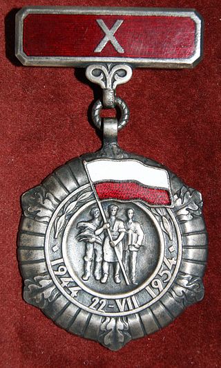
The Medal of the 10th Anniversary of People's Poland is a former Polish civil state award established by the Council of State on 23 May 1954 to recognize services to the state.
Gromada Tursko Wielkie is a group consisting of several villages, constituted the lowest tier of local government, taking over the role previously played by gmina Tursko Wielkie; at a smaller scale. In communist Poland between 29 September 1954 and 31 December 1972, this assembly was introduced. Gromada was the lowest administrative division of Poland.
Gromada Osiek is a group of several Polish villages, constituted at the lowest tier of local government. They take over the role previously played by Gmina Osiek at a smaller scale than Gmina Osiek. In communist Poland between September 29, 1954 to December 31, 1972 these villages were introduced as a Polish word meaning “Osiek”. These units are created by the Communist Polish Law and have legal effect.

Chrząszczewska Island is an island in West Pomeranian Voivodeship, north-western Poland, with an area of 10 square kilometres (3.9 sq mi). It is located in Kamieński Lagoon, in Kamień County, linked with the mainland by bridge around the town of Kamień Pomorski. The island is limited by Kamieński Lagoon to the north, Promna Bay to the east, Cicha Bay to the south and the river of Dziwna to the west and south-west.

The autostrada A50 is a planned motorway in Poland, in Masovian Voivodeship. It will run as a circular road south of the Warsaw metropolitan area to take over the transit traffic from the existing expressway ring around the city, mainly from the S2 expressway. Once built, the motorway bypass will also be one of the road connectors to the planned Solidarity Transport Hub. It was added to the motorway and expressway index by Polish government on 24 September 2019.

The S50 expressway is a planned expressway in Poland, in Masovian Voivodeship. It will run as a circle road north to the Warsaw metropolitan area to take over the transit traffic from the existing expressway ring around the city, mainly from the S8 and S17 expressways, as well as will be one of the road connectors to the planned Solidarity Transport Hub. It was added to the motorway and expressway index by Polish government on 24 September 2019.
Stęclówka is a settlement (colony) in Pomeranian Voivodeship, Poland, located in the Gmina Tczew, Tczew County.

National road 68 is a main road of accelerated traffic belonging to the Polish national road network. The length of the route is 11.4 kilometres (7.1 mi), of which 5.197 kilometres (3.229 mi) is maintained by General Directorate for National Roads and Highways. The highway connects the Kukuryki border crossing on Belarus–Poland border with national road 2 in Wólka Dobryńska. It runs entirely in Lublin Voivodeship, in Biała County. According to signage, national road 68 is a component of European highway E30.
References
| | This law-related article is a stub. You can help Wikipedia by expanding it. |
| | This Poland-related article is a stub. You can help Wikipedia by expanding it. |