The Lower Colorado River Authority (LCRA) is a nonprofit public utility created in November 1934 by the Texas Legislature. LCRA's mission is to enhance the lives of the Texans it serves through water stewardship, energy and community service. LCRA provides public power, manages the lower Colorado River, builds and operates transmission lines, owns public parks, and offers community services.

The Colorado River is one of the principal rivers in the Southwestern United States and northern Mexico. The 1,450-mile-long (2,330 km) river drains an expansive, arid watershed that encompasses parts of seven U.S. states and two Mexican states. Starting in the central Rocky Mountains of Colorado in Grand Lake, Colorado, the river flows generally southwest across the Colorado Plateau and through the Grand Canyon before reaching Lake Mead on the Arizona–Nevada border, where it turns south toward the international border. After entering Mexico, the Colorado approaches the mostly dry Colorado River Delta at the tip of the Gulf of California between Baja California and Sonora.

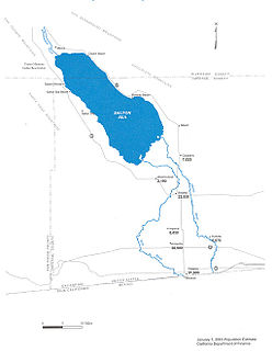
The Salton Sea is a shallow, landlocked, highly-saline body of water in Riverside and Imperial counties at the southern end of the U.S. state of California. It lies on the San Andreas Fault within the Salton Trough that stretches to the Gulf of California in Mexico. Over millions of years, the Colorado River has flowed into the Imperial Valley and deposited alluvium (soil), creating fertile farmland, building up the terrain, and constantly moving its main course and river delta. For thousands of years, the river has alternately flowed into the valley, or diverted around it, creating either a saline lake called Lake Cahuilla, or a dry desert basin, respectively. When the Colorado River flows into the valley, the lake level depends on river flows and the balance between inflow and evaporative loss. When the river diverts around the valley, the lake dries completely, as it did around 1580. Hundreds of archaeological sites have been found, indicating possibly long-term Native American villages and temporary camps.

The San Juan River is a major tributary of the Colorado River in the Southwestern United States, providing the chief drainage for the Four Corners region of Colorado, New Mexico, Utah, and Arizona. Originating as snowmelt in the San Juan Mountains of Colorado, it flows 383 miles (616 km) through the deserts of northern New Mexico and southeastern Utah to join the Colorado River at Glen Canyon.

The Gunnison River is located in western Colorado, and it is one of the largest tributaries of the Colorado river. The 180-mile (289-km) long river flows east to west, and it has a drainage area of 7,923 square miles (20,520 km2) according to the USGS. The drainage basin of the Gunnison River collects water from different habitats, such as forests and alpine meadows, located the along Continental Divide. As the river flows westward, it carves through the San Juan Mountains. It flows into the Colorado River at Grand Junction.

The Dirty Devil River is an 80-mile-long (130 km) tributary of the Colorado River, located in the U.S. state of Utah. It flows through southern Utah from the confluence of the Fremont River and Muddy Creek before emptying into the Colorado River at Lake Powell.
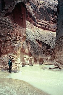
The Paria River is a tributary of the Colorado River, approximately 95 miles (153 km) long, in southern Utah and northern Arizona in the United States. It drains a rugged and arid region northwest of the Colorado, flowing through roadless slot canyons along part of its course.
The Colorado River dispute is a long-running dispute between the United States and Mexico over water rights to the Colorado River.

The Metropolitan Water District of Southern California is a regional wholesaler and the largest supplier of treated water in the United States. The name is usually shortened to "Met," "Metropolitan," or "MWD." It is a cooperative of fourteen cities, eleven municipal water districts, and one county water authority, that provides water to 19 million people in a 5,200-square-mile (13,000 km2) service area. It was created by an act of the California Legislature in 1928, primarily to build and operate the Colorado River Aqueduct. Metropolitan became the first contractor to the State Water Project in 1960.
The New River flows north from near Cerro Prieto, through the city of Mexicali, Baja California, Mexico, into the United States through the city of Calexico, California, towards the Salton Sea. The river channel has existed since pre-historic times. However, the river as known today formed from a levee failure and massive flooding that filled the Salton Sea.

Government of India constituted a common tribunal on 10 April 1969 to adjudicate the river water utilization disputes among the river basin states of Krishna and Godavari rivers under the provisions of Interstate River Water Disputes Act – 1956. The common tribunal was headed by Sri RS Bachawat as its chairman with Sri DM Bhandari and Sri DM Sen as its members. Krishna river basin states Maharashtra, Karnataka and old Andhra Pradesh insisted on the quicker verdict as it had become more expedient for the construction of irrigation projects in Krishna basin. So the proceedings of Krishna Water Disputes Tribunal (KWDT) were taken up first separately and its final verdict was submitted to GoI on 27 May 1976.

The environmental effects of irrigation relate to the changes in quantity and quality of soil and water as a result of irrigation and the subsequent effects on natural and social conditions in river basins and downstream of an irrigation scheme. The effects stem from the altered hydrological conditions caused by the installation and operation of the irrigation scheme.
The Colorado River Basin Salinity Control Act, Public Law 93-320, and the laws authorizing three other conservation cost-sharing programs were begun June 24, 1974. In the 1996 farm bill, Public Law 104-127, they were repealed and replaced by a new cost-sharing program, the Environmental Quality Incentives Program (EQIP).

The Environmental Quality Incentives Program (EQIP) is a United States government program designed to assist farmers in improving environmental quality, particularly water quality and soil conservation. Congress established the program in the 1996 farm bill to provide primarily cost-sharing assistance, but also technical and educational assistance, aimed at promoting production and environmental quality, and optimizing environmental benefits.
Colorado River Watch is a statewide volunteer water quality monitoring program operated by the non-profit organization Earth Force, in collaboration with Colorado Parks and Wildlife. Its mission is to work with voluntary stewards to monitor water quality and other indicators of watershed health, and utilize this high quality data to educate citizens and inform decision makers about the condition of Colorado's waters. This data is also used in the Clean Water Act decision-making process. River Watch's motto is "Real people doing real science for a real purpose."

The California State Water Resources Control Board (SWRCB) is one of six branches of the California Environmental Protection Agency.
The Division of Water Resources within the Kansas Department of Agriculture governs the use and allocation of the state's water resources; regulates the construction of dams, levees and other changes to streams; represents Kansas on its four interstate river compacts; and coordinates the National Flood Insurance Program in Kansas. These responsibilities are accomplished through the administration of 30 state laws, including the Kansas Water Appropriation Act, Groundwater Management District Act, Obstructions in Streams, and the Levee Law.
The Coachella Valley Water District is an independent special district formed in 1918, specifically to protect and conserve local water sources in the Coachella Valley. Since then, the district has grown into a multi-faceted agency that delivers irrigation and domestic (drinking) water, collects and recycles wastewater, provides regional storm water protection, replenishes the groundwater basin and promotes water conservation.

The Interstate Commission on the Potomac River Basin (ICPRB) is an agency composed of commissioners representing the federal government, the states of Maryland, Pennsylvania, Virginia, West Virginia, and the District of Columbia. The ICPRB mission is to enhance, protect, and conserve the water and associated land resources of the Potomac River basin and its tributaries through regional and interstate cooperation.

The 2017 production of coalbed methane in the United States was 0.98 trillion cubic feet (TCF), 3.6 percent of all US dry gas production that year. The 2017 production was down from the peak of 1.97 TCF in 2008. Most coalbed methane production came from the Rocky Mountain states of Colorado, Wyoming, and New Mexico.