
Leicester is a city, unitary authority area, unparished area and the county town of Leicestershire in the East Midlands of England. It is the largest city in the East Midlands with a population of 373,399 in 2022. The greater Leicester urban area had a population of 559,017 in 2021, making it the 11th most populous in England, and the 13th most populous in the United Kingdom. A 2023 report ranked Leicester 16th out of the 50 largest UK cities on a range of economic measures, and the first of seven East Midlands cities.

Leicestershire is a ceremonial county in the East Midlands of England. It is bordered by Derbyshire, Nottinghamshire and Lincolnshire to the north, Rutland to the east, Northamptonshire to the south-east, Warwickshire to the south-west, and Staffordshire to the west. The city of Leicester is the largest settlement and the county town.

The West End of London is a district of Central London, London, England, west of the City of London and north of the River Thames, in which many of the city's major tourist attractions, shops, businesses, government buildings and entertainment venues, including West End theatres, are concentrated.

Doral is a city in Miami-Dade County, Florida, United States. One of 34 municipalities in the county, it is located 5 miles (8 km) west of Miami International Airport and 13 miles (21 km) west of Downtown Miami. Doral occupies 15 square miles (39 km2) bordered on the west by the Ronald Reagan Turnpike and the Florida Everglades, on the north by the town of Medley, on the east by the Palmetto Expressway and on the south by the Dolphin Expressway and the city of Sweetwater. The city is part of the Miami metropolitan area of South Florida. As of the 2020 census, Doral had a population of 75,874, up from 45,704 in 2010.

De Montfort University Leicester (DMU) is a public university in the city of Leicester, England. It was established in accordance with the Further and Higher Education Act in 1992 as a degree awarding body. The name De Montfort University was taken from Simon de Montfort, a 13th-century Earl of Leicester.

Midtown Manhattan is the central portion of the New York City borough of Manhattan, serving as the city's primary central business district. Midtown is home to some of the city's most prominent buildings, including the Empire State Building, the Chrysler Building, the Hudson Yards Redevelopment Project, the headquarters of the United Nations, Grand Central Terminal, and Rockefeller Center, as well as several prominent tourist destinations, including Broadway, Times Square, and Koreatown. Penn Station in Midtown Manhattan is the busiest transportation hub in the Western Hemisphere.

Blaby is a local government district in Leicestershire, England. The district is named after the village of Blaby, although the council is based in Narborough. The district covers an area lying south-west of the city of Leicester. Several of the district's settlements form part of the wider Leicester Urban Area, including Glenfield, where Leicestershire County Council has its headquarters at County Hall, and the town of Braunstone.

Downtown Los Angeles (DTLA) is the central business district of the city of Los Angeles. It is part of the Central Los Angeles region and covers a 5.84 sq mi (15.1 km2) area. As of 2020, it contains over 500,000 jobs and has a population of roughly 85,000 residents, with an estimated daytime population of over 200,000 people prior to the COVID-19 pandemic.

Pride Park is a business park on the southern outskirts of the city centre of Derby, England. It covers 80 hectares of contaminated former industrial land between the River Derwent and railway lines, and was developed between the 1990s and early 2000s. Pride Park Stadium, Derby Arena and The Sanctuary Local Nature Reserve are also located within Pride Park.

Lichfield District is a local government district in Staffordshire, England. The district is named after its largest settlement, the city of Lichfield, which is where the district council is based. The district also contains the towns of Burntwood and Fazeley, along with numerous villages and surrounding rural areas, including part of Cannock Chase, a designated Area of Outstanding Natural Beauty.
Leicester City Centre is Leicester's historical commercial, cultural and transport hub and is home to its central business district. Its inner core is roughly delineated by the A594, Leicester's inner ring road, although the various central campuses of the University of Leicester, De Montfort University and Leicester College are adjacent to the inner ring road and could be considered to be a continuation of the City centre. In a similar way, the Leicester Royal Infirmary precinct, New Walk business district (Southfields), the Welford Road Stadium of Leicester Tigers’ RUFC and the King Power Stadium of Leicester City to the south, and the Golden Mile to the north could also be deemed to be extensions to the central core.

Clarendon Park is an area in the south of the city of Leicester. It is bordered by Welford Road to the west, London Road to the east, Victoria Park to the north and Avenue Road/Avenue Road Extension to the south. It is part of Castle Ward and the constituency of Leicester South. There are two major shopping streets; Queens Road and Clarendon Park Road. These two roads intersect near the centre of Clarendon Park, with Queens Road running north–south, and Clarendon Park Road running east–west.
Braunstone is a town and civil parish in the district of Blaby in Leicestershire, England. At the 2011 census the population of the town was 16,850.

Western Park is a park and surrounding suburb located in West End of Leicester. It is also a ward of the City of Leicester whose population at the 2011 census was 10,609.

Centre Street is a north–south street in the New York City borough of Manhattan, running through the Civic Center, Chinatown, and Little Italy neighborhoods of Lower Manhattan. It connects Park Row to the south with Cleveland Place to the north. Centre Street carries northbound traffic north of Reade Street and two-way traffic between Reade Street and the Brooklyn Bridge.

Government Center is a district in Downtown Newark, New Jersey, bounded by Broad Street, Green Street, Mulberry Street, and Beach Street and named for the presence of government buildings centered around a plaza called Federal Square. Grace Episcopal Church, a national historic site, where the tune of America the Beautiful was written, is within the area. The larger-than-life bust Justice, a statue of George Floyd and another of Mayor Kenneth A. Gibson are in the district.
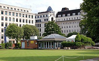
Finsbury Square is a 0.7-hectare (1.7-acre) square in Finsbury in central London which includes a six-rink grass bowling green. It was developed in 1777 on the site of a previous area of green space to the north of the City of London known as Finsbury Fields, in the parish of St Luke's and near Moorfields. It is sited on the east side of City Road, opposite the east side of Bunhill Fields. It is approximately 200m north of Moorgate station, 300m north-west of Liverpool Street station and 400m south of Old Street station. Nearby locations are Finsbury Circus and Finsbury Pavement. Named after it, but several miles away, are Finsbury Park and its eponymous neighbourhood. The centre of the square includes an underground NCP Car Park and two disused petrol stations, also owned by NCP for above-ground commercial parking. Finsbury Square is served by bus routes 21, 43, 141 and 214.

Donington Hall is a country house set in parkland near Castle Donington village, North West Leicestershire. The Hall and Estate was purchased in April 2021 by MotorSport Vision, which also operates the neighbouring Donington Park racing circuit.

Beaumont Shopping Centre is in Beaumont Leys, on the edge of Leicester. The 301,099 sq ft (27,973.0 m2) shopping centre is owned by British Land and managed by GVA.

The Leicester City Police Headquarters is a historic building located in Leicester, England. It was built during 1931–33 as the headquarters of the Leicester City Police.
