
Brandon is an unincorporated community and census-designated place (CDP) in Hillsborough County, Florida, United States. It is part of the Tampa–St. Petersburg–Clearwater Metropolitan Statistical Area. The population was 114,626 at the 2020 census, up from 103,483 at the 2010 census.

U.S. Route 92 or U.S. Highway 92 is a 181-mile (291 km.) U.S. Route entirely in the U.S. state of Florida. The western terminus is at US 19 Alt. and SR 687 in downtown St. Petersburg. The eastern terminus is at SR A1A in Daytona Beach.
The Millionaires' Mile, Millionaires' Row, Billionaires Row, Golden Mile or Alpha Street are the exclusive residential neighborhoods of various cities, often along one scenic strip such as a riverside or hilltop drive, or a wide city boulevard.
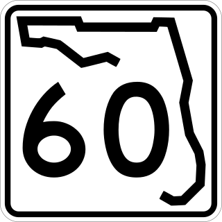
State Road 60 is an east–west route transversing Florida from the Gulf of Mexico to the Atlantic Ocean. The western terminus of SR 60 is at the Sunsets at Pier 60 site in Clearwater Beach. The eastern terminus is in Vero Beach near the Atlantic Coast just past State Road A1A.
Tampa Heights is one of the oldest neighborhoods within the city limits of Tampa, situated in the central part of the city. As of the 2000 census, the neighborhood had a population of 16,393.

West Tampa is one of the oldest neighborhoods within the city limits of Tampa, Florida, United States. It was an independently incorporated city from 1895 until 1925, when it was annexed by Tampa.

Hyde Park is a historic neighborhood and district within the city limits of Tampa. It includes Bayshore Boulevard, Hyde Park Village and SoHo. Its ZIP code is 33606. Hyde Park includes many historic homes and bungalows. Its history and proximity to downtown Tampa make it a desirable residential neighborhood. Because of its convenient location, developments are being built in Hyde Park. Construction includes an expansion of Hyde Park Village, an upscale shopping and dining destination, as well as multifamily residential developments.
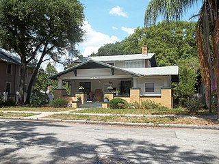
Seminole Heights is a historic neighborhood and district located in central Tampa. It includes many early 20th century bungalow homes and historic buildings. It was an early residential area of Tampa connected by streetcar. The area had an economic downturn in the late 20th century marked by increased crime, but has since seen a resurgence with new restaurants, brew pubs and independent businesses opening up. The neighborhood's historic homes, eclectic shops and gourmet restaurants are an increasing draw.
The Tampa Heights Historic District is a U.S. historic district in Tampa, Florida. It is bounded by Adalee Street, I-275, 7th Avenue and North Tampa Avenue, encompasses approximately 200 acres (0.81 km2), and contains 289 historic buildings. On August 4, 1995, it was added to the U.S. National Register of Historic Places. The district includes Lee Elementary School of Technology World Studies, the first brick school in Hillsborough County, Florida.

The Seminole Heights Residential District, known also as the Seminole Heights Historic District, is a U.S. and Local Historic District located in Tampa, Florida. The district is roughly bounded by Hanna Avenue to the north, Cherokee Avenue and I-275 to the east, Florida Avenue to the west, and Osborne Avenue to the south.

The cityscape of Tampa includes historic and architecturally noteworthy structures in its downtown and residential areas. The Seminole Heights and Hyde Park neighborhoods are two of the largest historic preservation districts in Tampa.
Bowman Heights is a neighborhood within the district of West Tampa, which represents District 6 of the Tampa City Council. Demographically, The neighborhood did not report separately.
Old Seminole Heights is a neighborhood within the city limits of Tampa, in the U.S. state of Florida. The neighborhood is one of three which comprise the greater Seminole Heights district within the city. As of the 2010 census the neighborhood had a population of 14,729. The ZIP Codes serving the area are 33603, 33604, and 33610.
Rattlesnake is a neighborhood and former unincorporated community located in the South Tampa district of Tampa, Florida.
Oak Park is a neighborhood within the city limits of Tampa, in the U.S. state of Florida. The ZIP Code which serves the neighborhood is 33605. The neighborhood is part of the East Tampa region and is located within District Five of the Tampa City Council.
Harvey Heights is a neighborhood in the northern area of Tampa, Florida, which represents District 7 of the Tampa City Council. The 2000 census numbers were unavailable; however, the latest estimated population was 285.

Lee Elementary School of Technology/ World Studies was a historic elementary school in Tampa, Florida. It was established as Michigan Avenue Grammar School in 1906. It became Robert E. Lee Elementary School in 1943 when Michigan Avenue was renamed Columbus Drive (Tampa). The school was located at 305 East Columbus Drive and was the first brick school building constructed in Hillsborough County, Florida. In 2004, it became Lee Elementary School of Technology/World Studies. The school's colors are royal blue and gold and its mascot is Robert E. Lee's horse Traveller.
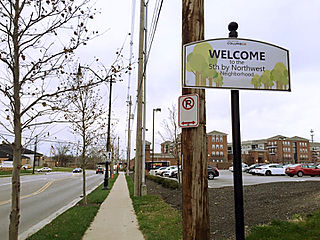
Fifth by Northwest is a neighborhood in Columbus, Ohio. Covering about 700 acres (280 ha), Fifth by Northwest is approximately bound by Glenn Avenue, Wyandotte Road, & Kinnear to the north, Third Avenue to the south, Kenny Road and Olentangy River Road to the east and Northstar Road to the west. Also sometimes referred to as 5XNW or the Tri-Village area, Fifth by Northwest is just north of Grandview Heights, northwest of the Harrison West neighborhood, and west of The Ohio State University.


