
Carnuntum was a Roman legionary fortress and headquarters of the Pannonian fleet from 50 AD. After the 1st century, it was capital of the Pannonia Superior province. It also became a large city of 50,000 inhabitants.

The Roxolani or Rhoxolāni were a Sarmatian people documented between the 2nd century BC and the 4th century AD, first east of the Borysthenes (Dnieper) on the coast of Lake Maeotis, and later near the borders of Roman Dacia and Moesia. They are believed to be an offshoot of the Alans.

Līmes is a modern term used primarily for the Germanic border defence or delimiting system of Ancient Rome marking the borders of the Roman Empire, but it was not used by the Romans for that purpose. The term has been extended to refer to the frontier defences in other parts of the empire, such as in the east and in Africa.
Donau-Ries (Danube-Ries) is a Landkreis (district) in Swabia, Bavaria, Germany. It is bounded by the districts of Ansbach, Weißenburg-Gunzenhausen, Eichstätt, Neuburg-Schrobenhausen, Aichach-Friedberg, Augsburg and Dillingen, and by the state of Baden-Württemberg.
The Limes Germanicus is the name given in modern times to a line of frontier fortifications that bounded the ancient Roman provinces of Germania Inferior, Germania Superior and Raetia, dividing the Roman Empire and the unsubdued Germanic tribes from the years 83 to about 260 AD. The Limes used either a natural boundary such as a river or typically an earth bank and ditch with a wooden palisade and watchtowers at intervals. A system of linked forts was built behind the Limes.

Devín Castle is a castle in Devín, which is a borough of Bratislava, the capital of Slovakia.

Vindobona was a Roman military camp in the province of Pannonia, located on the site of the modern city of Vienna in Austria. The settlement area took on a new name in the 13th century, being changed to Berghof, or now simply known as Alter Berghof.
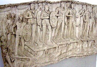
The Auxilia were introduced as non-citizen troops attached to the citizen legions by Augustus after his reorganisation of the Imperial Roman army from 27 BC. By the 2nd century, the Auxilia contained the same number of infantry as the legions and, in addition, provided almost all of the Roman army's cavalry and more specialised troops. The auxilia thus represented three-fifths of Rome's regular land forces at that time. Like their legionary counterparts, auxiliary recruits were mostly volunteers, not conscripts.

Bremetennacum,, or Bremetennacum Veteranorum, was a Roman fort on the site of the present day village of Ribchester in Lancashire, England. The site is a Scheduled Monument.

In modern scholarship, the "late" period of the Roman army begins with the accession of the Emperor Diocletian in AD 284, and ends in 480 with the death of Julius Nepos, being roughly coterminous with the Dominate. During the period 395–476, the army of the Roman Empire's western half progressively disintegrated, while its counterpart in the East, known as the East Roman army remained largely intact in size and structure until the reign of Justinian I.

The Alpine regiments of the Roman army were those auxiliary units of the army that were originally raised in the Alpine provinces of the Roman Empire: Tres Alpes, Raetia and Noricum. All these regions were inhabited by predominantly Rhaetian peoples and Celtic-speaking tribes. They were annexed, or at least occupied, by the emperor Augustus' forces during the period 25–14 BC. The term "Alpine" is used geographically in this context and does not necessarily imply that the regiments in question were specialised in mountain warfare. However, in the Julio-Claudian period, when the regiments were still largely composed of Alpine recruits, it is likely that they were especially adept at mountain operations.

The Imperial Roman army was the military land force of the Roman Empire from 27 BC to 476 AD, and the final incarnation in the long history of the Roman army. This period is sometimes split into the Principate and the Dominate (284–476) periods.

Slovakia was partly occupied by Roman legions for a short period of time. Marcomannia was a proposed province of the Roman Empire that Emperor Marcus Aurelius planned to establish in this territory. It was inhabited by the Germanic tribes of Marcomanni and Quadi, and lay in the western parts of the modern states and Slovakia and the Czech Republic (Moravia). Part of the area was occupied by the Romans under Marcus Aurelius between 174 AD and 180 AD. His successors abandoned the project, but the people of the area became steadily Romanized during the next two centuries. The Roman influence was disrupted with the invasions of Attila starting around 434 AD and as Slavic people later began to move into the area.
By the size of the Roman army is meant the changes in the number of its contingents: legions, auxiliaries, Praetorian cohorts, Urban cohorts, vigiles, and naval forces over the course of twelve centuries – from 753 BC to AD 476.

Derventio, sometimes described as Derventio Brigantium in order to distinguish it from other places called Derventio, was a Roman fort and settlement located beneath the modern town of Malton in North Yorkshire, England. The fort is positioned 18 miles north-east of Eboracum on the River Derwent.
The Danubian Limes, or Danube Limes, refers to the Roman military frontier or limes which lies along the River Danube in the present-day German state of Bavaria, in Austria, Slovakia, Hungary, Croatia, Serbia, Bulgaria and Romania.

Lancaster Roman Fort, also known as Wery Wall, Galacum or Calunium, is the modern name given to ruined former Roman fort atop Castle Hill in Lancaster in North West England. The first castra was founded c. 80 AD within the Roman province of Britannia.


