The Mid-Atlantic Ridge is a mid-ocean ridge located along the floor of the Atlantic Ocean, and part of the longest mountain range in the world. In the North Atlantic, the ridge separates the North American from the Eurasian Plate and the African Plate, north and south of the Azores Triple Junction. In the South Atlantic, it separates the African and South American plates. The ridge extends from a junction with the Gakkel Ridge northeast of Greenland southward to the Bouvet Triple Junction in the South Atlantic. Although the Mid-Atlantic Ridge is mostly an underwater feature, portions of it have enough elevation to extend above sea level, for example in Iceland. The ridge has an average spreading rate of about 2.5 centimetres (1 in) per year.

Bananal Island is a large river island formed from the bisection of the Araguaia River, in southwestern Tocantins, Brazil. The island is formed by a fork in a very flat section of the Araguaia River. Bananal Island is the second largest river island in the world and the largest without an ocean coastline, at 350 kilometres (220 mi) long and 55 kilometres (34 mi) wide. Its total area is 19,162.25 square kilometres (7,398.59 sq mi). The rivers within the island flow parallel to the Araguaia, and the Jaburu do Bananal is the longest river within a river.

The Camp is the term used in the Falkland Islands to refer to any part of the islands outside the islands' only significant town, Stanley, and often the large RAF base at Mount Pleasant. It is derived from the Spanish word campo, for "countryside".
Skelton Glacier is a large glacier flowing from the polar plateau into the Ross Ice Shelf at Skelton Inlet on the Hillary Coast, south of Victoria Land, Antarctica.

Grenadines is an administrative parish of Saint Vincent and the Grenadines, comprising the islands of the Grenadines other than those belonging to Grenada. The capital is Port Elizabeth.
The Northumberland Islands are a scattered island chain off the eastern coast of Queensland, Australia.

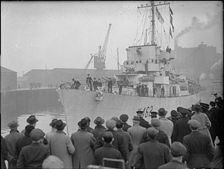
HMS Affleck was a Captain-class frigate which served during World War II. The ship was named after Sir Edmund Affleck, commander of HMS Bedford at the Moonlight Battle in 1780 during the American Revolutionary War.
San Francisco Mountains National Forest was established as the San Francisco Mountains Forest Reserve by the General Land Office in Arizona on August 17, 1898 with 975,360 acres (3,947.1 km2). After the transfer of federal forests to the U.S. Forest Service in 1905, it became a National Forest on March 4, 1907. On July 1, 1908 the entire forest was combined with other lands to create Coconino National Forest and the name was discontinued.
Gogui is a small town and rural commune in the Cercle of Nioro in the Kayes Region of western Mali. The town is on the border with Mauritania.
Outat El Haj is a town in Boulemane Province, Fès-Meknès, Morocco. According to the 2014 census it has a population of 16 388. The population consists primarily of Berber tribes from the villages in the middle Atlas mountains and Arab tribes from the low lands towards Guercif and Talsint.
Umirim is a municipality in the state of Ceará in the Northeast region of Brazil.
Agudos do Sul is a municipality in the state of Paraná in the Southern Region of Brazil.
Campo do Tenente is a municipality in the state of Paraná in the Southern Region of Brazil.
Porto Alegre do Tocantins is a municipality in the state of Tocantins in the Northern region of Brazil.
Miranda (La Rioja) is a municipality and village in La Rioja Province in northwestern Argentina.
Cape Christmas is an abrupt rock cape which rises to 320 metres (1,050 ft), marking the north side of the entrance to Wüst Inlet, on the east coast of Palmer Land. It was discovered and photographed from the air in December 1940 by the United States Antarctic Service; during 1947 it was photographed from the air by the Ronne Antarctic Research Expedition under Finn Ronne, who in conjunction with the Falkland Islands Dependencies Survey (FIDS) charted it from the ground. It was so named by the FIDS because the joint party in 1947 spent Christmas Day, December 25, in this vicinity.
This page is based on this
Wikipedia article Text is available under the
CC BY-SA 4.0 license; additional terms may apply.
Images, videos and audio are available under their respective licenses.


