
This is a list of the extreme points of Ireland – the points that are furthest north, south, east or west in Ireland. It includes the Republic of Ireland and Northern Ireland.
Skelton Glacier is a large glacier flowing from the polar plateau into the Ross Ice Shelf at Skelton Inlet on the Hillary Coast, south of Victoria Land, Antarctica.

Alto Rio Doce is a Brazilian municipality in the state of Minas Gerais. As of 2020 its population is estimated to be 10,859.
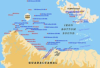
Lunga Point is a promontory on the northern coast of Guadalcanal, the site of a naval battle during World War II. It was also the name of a nearby airfield, later named Henderson Field. USS Lunga Point is also the name of a United States Navy escort carrier that operated in World War II.

Caloto is a town and municipality in the Cauca Department, Colombia. It was founded on June 29, 1543 by Sebastián de Belalcázar.

Sasamón is a municipality and town located in the province of Burgos, Castile and León, Spain. According to the 2004 census (INE), the municipality has a population of 1,346 inhabitants.
Fuentes de Ayódar is a municipality in the comarca of Alto Mijares, Castellón, Valencia, Spain.

Joaíma is a Brazilian municipality located in the northeast of the state of Minas Gerais.

Bermagui River is an open and trained semi-mature wave dominated barrier estuary or perennial river located in the South Coast region of New South Wales, Australia.
León (Jujuy) is a rural municipality and village in Jujuy Province in Argentina.

Apolinario Saravia (Salta) is a town and municipality in Salta Province in northwestern Argentina.

Caraquet Rock is a rock lying nearly 4 nautical miles (7 km) west-southwest of Bell Point, off the west part of King George Island in the South Shetland Islands. It was named by the UK Antarctic Place-Names Committee in 1960 for the sealing vessel Caraquet from Liverpool, which visited the South Shetland Islands in 1821–22.
Cumpston Glacier is a small glacier on the east coast of Graham Land, draining between Breitfuss Glacier and Quartermain Glacier into the head of Mill Inlet. It was named by the UK Antarctic Place-Names Committee for J.S. Cumpston, an Australian historian of the Antarctic.
The Fish Islands are a group of small islands lying in the northern part of the entrance to Holtedahl Bay, off the west coast of Graham Land, Antarctica. They were discovered and named by the British Graham Land Expedition, 1934–37, under John Rymill.

Kenney Glacier is a glacier 1 nmi long flowing northwest from The Pyramid and The Saddlestone into Depot Glacier, near the head of Hope Bay, Trinity Peninsula, Antarctica. It was mapped in 1945 and 1948 by the Falkland Islands Dependencies Survey (FIDS), was resurveyed by the FIDS in 1955, and was named for Richard Kenney, assistant surveyor at Hope Bay in 1954 and 1955, who made a detailed local survey of the area between Hope Bay and Duse Bay.

Levko Glacier is a glacier flowing from Pallid Crest to the eastern end of Thurston Island, Antarctica. It enters Seraph Bay between Tierney Peninsula and Simpson Bluff. The glacier was named by the Advisory Committee on Antarctic Names after G. Levko, Photographer's Mate in the Eastern Group of U.S. Navy Operation Highjump, which obtained aerial photographs of Thurston Island and adjacent coastal areas, 1946–47.
Lakhnafif is a small town and rural commune located in Taroudant Province of the Souss-Massa-Drâa region of Morocco. At the time of the 2004 census, the commune had a total population of 8881 people living in 1513 households.
