Related Research Articles
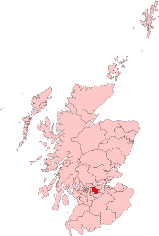
Airdrie and Shotts is a constituency of the UK House of Commons, located in central Scotland within the North Lanarkshire council area. It elects one Member of Parliament (MP) at least once every five years using the first-past-the-post system of voting.
Balzac is a hamlet in Rocky View County, which is in the Calgary Metropolitan Region of the Canadian province of Alberta. It is located immediately west of Queen Elizabeth II Highway, at the intersection with Highway 566, 24 km (15 mi) north of Calgary city centre and 12 km (7.5 mi) south of Airdrie.

Bowling railway station serves the village of Bowling in the West Dunbartonshire region of Scotland. This station is on the North Clyde Line, 12¼ miles (20 km) west of Glasgow Queen Street.

Bellgrove Railway Station is in the East End of Glasgow, Scotland, serving the city's Calton, Gallowgate and south Dennistoun neighbourhoods. The station is approximately 1 mile (1.6 km) to the east of Glasgow Queen Street, and is managed by ScotRail.
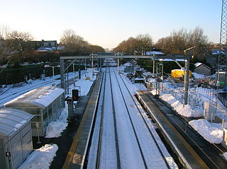
Airdrie railway station is a railway station serving the town of Airdrie, North Lanarkshire, Scotland. The station is managed by ScotRail and is served by trains on the North Clyde Line, 11 miles (18 km) east of Glasgow Queen Street.

The Airdrie–Bathgate rail link is a completed railway project in central Scotland.
The Monkland and Kirkintilloch Railway was an early mineral railway running from a colliery at Monklands to the Forth and Clyde Canal at Kirkintilloch, Scotland. It was the first railway to use a rail ferry, the first public railway in Scotland, and the first in Scotland to use locomotive power successfully, and it had a great influence on the successful development of the Lanarkshire iron industry. It opened in 1826.
Airdrie Public Observatory is a fully operational, historic astronomical observatory, which is part of the library building in the town of Airdrie, North Lanarkshire, Scotland. There are only four public observatories operating in the United Kingdom, all of which are in Scotland. Airdrie Observatory is the smallest, and second oldest.
The Hillend Loch Railway Path, also known as the Airdrie to Bathgate Railway Path, is a rail trail located in central Scotland. The path is approximately 14 miles (23 km) long and follows the route of the former Bathgate and Coatbridge Railway between Airdrie, North Lanarkshire (55.8662°N 3.9539°W), and Bathgate, West Lothian (55.8918°N 3.6224°W).
The Rutherglen and Coatbridge Railway was a railway line in Scotland built by the Caledonian Railway to shorten the route from the Coatbridge area to Glasgow. It opened in 1865. It was later extended to Airdrie in 1886, competing with the rival North British Railway. Soon after a further extension was built from Airdrie to Calderbank and Newhouse.

Bathgate railway station is a railway station serving Bathgate in West Lothian, Scotland. Opened on 18 October 2010, it is close to the junction of the former Edinburgh and Bathgate Railway and the former Bathgate and Coatbridge Railway to the east of the 1986 station. Ticket gates are in operation.
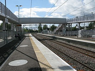
Drumgelloch railway station is a railway station serving the east of Airdrie, North Lanarkshire, Scotland. It is located 600 yards (550 m) east of the 1989 station on the former Bathgate and Coatbridge Railway, on the site of the former Clarkston railway station. The station previously closed in 1956.
Forrestfield is a small settlement in North Lanarkshire, Scotland. It is located on the A89 road, 3 kilometres (1.9 mi) east of Caldercruix and 4 kilometres (2.5 mi) west of Blackridge. Until 1956 the settlement had a railway station on the former Bathgate and Coatbridge Railway. This line reopened in 2010 as the Airdrie–Bathgate rail link, although Forrestfield station was not reopened. Cairneyhill Quarry, a whinstone quarry operated by Tarmac, lies 0.5 kilometres (0.31 mi) to the south of Forrestfield.

Longriggend is a village in North Lanarkshire, Scotland, with a population of approximately 200. It is situated on moorland 8 km north-east of Airdrie, in the parish of New Monkland. It is roughly half way between Upperton and Caldercruix. The village appeared on a map by Timothy Pont, under the name of Langrodge. It was published in 1596 but the letters are difficult to read. The toponymy is listed along with other -rigg placenames. Longriggend is also shown on another map by Roy c1754. Slamannan Railway joined Longriggend with Airdrie and the Union Canal in 1840, but its gauge prevented its connection with the Edinburgh & Glasgow Railway. Coal pits in the area used the railway extensively, and by 1895 there was a station at Longriggend. By 1901 its population had reached over 1500, and it had a post and telegraph office, and an inn nearby.
Stand is a hamlet in North Lanarkshire, Scotland situated on the A73 near Airdrie. Its Ordnance Survey grid reference is NS7668.

Gallowgate railway station was a station on the City Union Line in Glasgow, Scotland. It was situated a short distance east of Glasgow Cross at the junction of Gallowgate and East Nile Street, today Molendinar Street.

Garngad railway station was a railway station in Royston, Glasgow on the City Union Line, on the Garngad chord. It closed for passenger traffic in 1910.
Calderbank railway station served the village of Calderbank, North Lanarkshire, Scotland, from 1887 to 1930 on the Airdrie to Newhouse Branch.
Chapelhall railway station served the village of Chapelhall, North Lanarkshire, Scotland from 1887 to 1930 on the Airdrie to Newhouse Branch.
References
- ↑ "Station list" (PDF). Nbrstudygroup.co.uk. Archived from the original (PDF) on 4 March 2016. Retrieved 6 June 2017.
- ↑ Butt, R.V.J. (1995). The Directory of Railway Stations. Yeovil: Patrick Stephens Ltd. p. 67. ISBN 1-85260-508-1. R508.
| Preceding station | Disused railways | Following station | ||
|---|---|---|---|---|
| Terminus | North British Railway Hallcraig Street branch | Airdrie Hallcraig Street Line and station closed |
55°52′21″N3°59′16″W / 55.87250°N 3.98770°W
| | This Scotland railway station-related article is a stub. You can help Wikipedia by expanding it. |