Related Research Articles

Clay County is a county located in the U.S. state of Kansas. Its county seat and most populous city is Clay Center. As of the 2020 census, the county population was 8,117. The county was named for Henry Clay, an influential U.S. Senator from Kentucky.

Ottawa County is a county located in the U.S. state of Kansas. Its county seat and largest city is Minneapolis. As of the 2020 census, the county population was 5,735. The county was named after the Odawa tribe.

Cloud County is a county located in the U.S. state of Kansas. Its county seat and most populous city is Concordia. As of the 2020 census, the county population was 9,032. The county was named after William Cloud, an officer in the American Civil War.

Andover is a city in Butler County, Kansas, United States, and a suburb of Wichita. As of the 2020 census, the population of the city was 14,892. Andover is the most populated city in Butler County.

Clyde is a city in Cloud County, Kansas, United States. As of the 2020 census, the population of the city was 694. It is located east of Concordia along state highway K-9.
Concordia is a city in and the county seat of Cloud County, Kansas, United States. It is located along the Republican River in the Smoky Hills region of the Great Plains in North Central Kansas. As of the 2020 census, the population of the city was 5,111. Concordia is home of the Cloud County Community College and the Nazareth Convent and Academy.
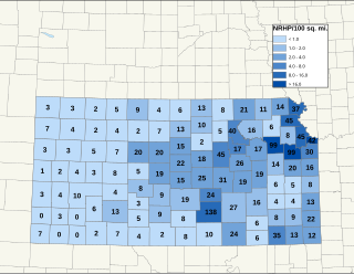
There are over 1,400 buildings, sites, districts, and objects in Kansas listed on the National Register of Historic Places in Kansas. NRHP listings appear in 101 of the state's 105 counties.

Cloud County Community College is a public community college with campuses in Concordia and Junction City, Kansas.
The St. Joseph Metropolitan Statistical Area, as defined by the United States Census Bureau, is an area consisting of four counties - three in northwest Missouri and one in northeast Kansas (Doniphan) - anchored by the city of St. Joseph, comprising a total area of 1,673.93 square miles (4,335.5 km2). As of the 2020 census, the MSA had a population of 121,467.

Napoleon Bonaparte Brown was an American businessman and politician who lived in Kansas and Missouri in the late 19th and early 20th centuries. He is most known as the namesake and builder of the Brown Grand Theatre in Concordia, Kansas.

The County Line Bowstring is a bridge located near unincorporated Hollis, Kansas, United States, that is listed on the National Register of Historic Places. It spans West Creek on the border between Cloud and Republic counties and has a wooden deck with a bowstring pony truss.

Rice is an unincorporated community in Cloud County, Kansas, United States.
St. Joseph is an unincorporated community in Cloud County, Kansas, United States.

The Cloud County Historical Museum is located in Concordia, Kansas. The Museum preserves and exhibits objects and documents of historical items representing early-day Kansas. It is housed in the former 1908 Carnegie library building and an annex.

The Coronado Area Council is the local council of the Boy Scouts of America (BSA) that serves Scouts in north central and northwest Kansas, across 32 counties, with headquarters in Salina.

The Iowa Reservation of the Iowa Tribe of Kansas and Nebraska straddles the borders of southeast Richardson County in southeastern Nebraska and Brown and Doniphan Counties in northeastern Kansas. Tribal headquarters are west of White Cloud, Kansas. The reservation was defined in a treaty from March 1861. Today the tribe operates Casino White Cloud on the reservation.

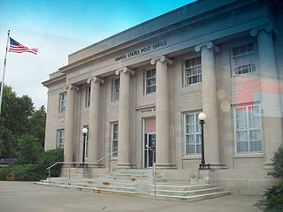
This is a list of the National Register of Historic Places listings in Cloud County, Kansas.
North Central Kansas is a tourism and geographical region of the state of Kansas. It consists of 15 counties, and has a population of over 150,000. The Salina micropolitan area is part of North Central Kansas. The region stretches from the Nebraska border in the north to Russell, Ellsworth, Saline, and Dickinson Counties in the south. Its western border includes Smith, Osborne, and Russell Counties, and its eastern border Dickinson, Clay, Washington, and Marshall Counties.
Macyville is a ghost town in Cloud County, Kansas, United States.

The 1976 United States presidential election in Kansas took place on November 2, 1976, as part of the 1976 United States presidential election. Kansas voters chose seven representatives, or electors, to the Electoral College, who voted for president and vice president.