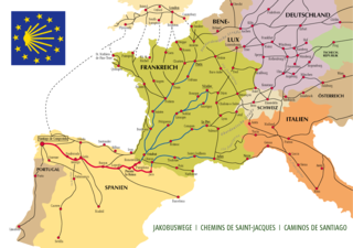
The Camino de Santiago, known in English as the Way of Saint James among other names, is a network of pilgrims' ways or pilgrimages leading to the shrine of the apostle Saint James the Great in the cathedral of Santiago de Compostela in Galicia in northwestern Spain, where tradition has it that the remains of the saint are buried. Many follow its routes as a form of spiritual path or retreat for their spiritual growth. It is also popular with hiking and cycling enthusiasts and organized tour groups.

Belorado is a village and municipality in Spain, belonging to the Province of Burgos, in the autonomous community of Castile-Leon. It has a population of approximately 2,100 inhabitants. It is also known for being a city in the Way of Saint James.

Puente La Reina is a town and municipality located in the autonomous community of Navarre, in northern Spain.

Torres del Río is a town and municipality located in the province and autonomous community of Navarre, northern Spain.

The Camino de Santiago extends from different countries of Europe, and even North Africa, on its way to Santiago de Compostela and Finisterre. The local authorities try to restore many of the ancient routes, even those used in a limited period, in the interest of charles.

Saint Fructuosus of Braga was the Bishop of Dumio and Archbishop of Braga, a great founder of monasteries, who died on 16 April 665. He was the son of a Visigothic dux in the region of Bierzo and at a young age accompanied his father on certain official trips over his estates.
The old monastery of San Juan de Ortega is a Romanesque monument in Barrios de Colina, in the province of Burgos, Spain.
The French Way is the most popular of the routes of the Way of St. James, the ancient pilgrimage route to Santiago de Compostela in Galicia, Spain. It runs from Saint-Jean-Pied-de-Port on the French side of the Pyrenees to Roncesvalles on the Spanish side and then another 780km on to Santiago de Compostela through the major cities of Pamplona, Logroño, Burgos and León. A typical walk on the Camino francés takes at least four weeks, allowing for one or two rest days on the way. Some travel the Camino on bicycle or on horseback.

Pedrafita do Cebreiro is a municipality in the province of Lugo in Galicia, Spain. It borders the Lugo municipalities of As Nogais, Cervantes, Folgoso do Courel, Samos and Triacastela. Its eastern boundary borders the province of León. It belongs to the comarca of Os Ancares.

Hospital de Órbigo is a municipality located in the province of León, Castile and León, Spain. According to the 2010 census (INE), the municipality has a population of 1,031 inhabitants.
Mansilla de las Mulas, Mansiella in Leonese language, is a municipality located in the province of León, Castile and León, Spain. According to the 2010 census (INE), the municipality has a population of 1,913 inhabitants.

Molinaseca is a village and municipality located in the region of El Bierzo. According to the 2010 census (INE), the municipality has a population of 818 inhabitants. It is located on the French Way, the most popular path of the Camino de Santiago.
Villanueva de las Manzanas is a municipality located in the province of León, Castile and León, Spain. According to the 2004 census (INE), the municipality has a population of 558 inhabitants.
Población de Campos is a municipality located in the province of Palencia, Castile and León, Spain. According to the 2004 census (INE), the municipality has a population of 179 inhabitants.
Santa Olalla de Bureba is a municipality and town located in the province of Burgos, Castile and León, Spain. According to the 2004 census (INE), the municipality has a population of 33 inhabitants.
Asturianos is a municipality located in the Sanabria comarca, province of Zamora, Castile and León, Spain. According to the 2009 census (INE), the municipality had a population of 267 inhabitants. The Leonese language is still spoken here. It is on the Sanabres variant of the Via de la Plata pilgrim camino to Santiago de Compostela.

Coatzintla is a municipality in Veracruz, Mexico. It is located in the north zone of the State of Veracruz, about 120 kilometres (75 mi) from the state capital Xalapa. It covers an area of 235.25 square kilometres (90.83 sq mi). It is located at 20°29′N97°28′W.

Monte do Gozo is a hill in Santiago de Compostela, Galicia, Spain. It is known for being the place where Christian pilgrims on the Camino de Santiago get their first views of the three spires of their destination, the Cathedral of Santiago de Compostela. At 370 metres (1,210 ft), it is the pilgrims' last hill and last stop before reaching the cathedral, with about an hour's walk still to go, and by tradition is where they cry out in rapture at finally seeing the end of their path.

Castrojeriz or Castrogeriz is a locality and municipality located in the province of Burgos, in the autonomous community of Castilla y León (Spain), the comarca of Odra-Pisuerga, the judicial district of Burgos, head of the town council of the same name and former head of the Castrojeriz judicial district.

El Acebo is a very small village on the Camino de Santiago in the Province of León in the Autonomous community of Castille-León. The village is named after the European Holly.