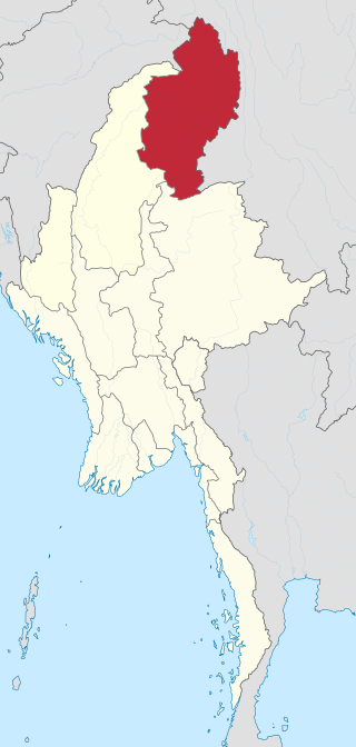
Kachin State is the northernmost state of Myanmar. It is bordered by China to the north and east ; Shan State to the south; and Sagaing Region and India to the west. It lies between north latitude 23° 27' and 28° 25' longitude 96° 0' and 98° 44'. The area of Kachin State is 89,041 km2 (34,379 sq mi). The capital of the state is Myitkyina. Other important towns include Bhamo, Mohnyin and Putao.

The Ledo Road was an overland connection between British India and China, built during World War II to enable the Western Allies to deliver supplies to China and aid the war effort against Japan. After the Japanese cut off the Burma Road in 1942 an alternative was required, hence the construction of the Ledo Road. It was renamed the Stilwell Road, after General Joseph Stilwell of the U.S. Army, in early 1945 at the suggestion of Chiang Kai-shek. It passes through the Burmese towns of Shingbwiyang, Myitkyina and Bhamo in Kachin state. Of the 1,726 kilometres (1,072 mi) long road, 1,033 kilometres (642 mi) are in Burma and 632 kilometres (393 mi) in China with the remainder in India. The road had the Ledo-Pangsau Pass-Tanai (Danai)-Myitkyina--Bhamo-Mansi-Namhkam-Kunming route.
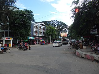
Myitkyina is the capital city of Kachin State in Myanmar (Burma), located 1,480 kilometers (920 mi) from Yangon, and 785 kilometers (488 mi) from Mandalay. In Burmese it means "near the big river", and Myitkyina is on the west bank of the Ayeyarwady River, just below 40 kilometers (25 mi) from Myit-son of its two headstreams. It is the northernmost river port and railway terminus in Myanmar. The city is served by Myitkyina Airport.
Air Mandalay was a regional airline based in Yangon. Its main base was Yangon International Airport. In early April 2015, two newly leased Embraer ERJ 145 jets joined its fleet.

Monywa is the largest city in Sagaing Region, Myanmar, located 136 kilometres (85 mi) north-west of Mandalay on the eastern bank of the River Chindwin. Monywa is one of the largest economic cities in Myanmar. It is also known as 'Neem City' because many of the city's streets are lined with neem trees.
Bhamo is a city in Kachin State in northern Myanmar, 186 km (116 mi) south of the state capital, (Myitkyina). It is on the Ayeyarwady River. It lies within 65 km (40 mi) of the border with Yunnan Province, China. The population consists of Chinese and Shan, with Kachin peoples in the hills around the town. It is the administrative center of Bhamo District and Bhamo Township.

Air Bagan Limited was an airline headquartered in Bahan Township, Yangon, Myanmar. It operated domestic scheduled services within Myanmar, as well as to Thailand. Its main bases were Yangon International Airport and Mandalay International Airport.
The University of Computer Studies, Yangon (UCSY), located in the outskirts of Yangon in Hlawga, is the leading IT and computer science university of Myanmar. The university, administered by the Ministry of Education, offers undergraduate and graduate degree programs in computer science and technology. The language of instruction at UCSY is English. Along with the University of Computer Studies, Mandalay, UCSY is one of two premier universities specializing in computer studies, and also one of the most selective universities in the country.

Myitkyina District is a district of the Kachin State in northern Burma (Myanmar). The capital lies at Myitkyina. It is the largest district in the country by land area.

Merrill's Marauders is a 1962 Technicolor war film, photographed in CinemaScope, and directed and co-written by Samuel Fuller. It is based on the exploits of the long-range penetration jungle warfare unit of the same name in the Burma campaign, culminating in the Siege of Myitkyina.

The Church of the Province of Myanmar in Asia is a member church of the Anglican Communion. The province comprises the entire country of Myanmar. The current archbishop of Myanmar and bishop of Yangon is Stephen Than Myint Oo.

Injangyang Township is a township of Myitkyina District in the Kachin State of Burma (Myanmar). The principal town and administrative center is Injangyang. The 2002 population estimate for the township was 23,370.

The University of Computer Studies, Mandalay (UCSM), located in Mandalay, is a Myanmar IT and computer science university. UCSM offers bachelor's, master's and doctoral degree programs in computer science and technology. The majority of its student body is from Upper Myanmar. Administered by the Ministry of Education, UCSM is the official university for all the Government Computer Colleges in Upper Myanmar, whose students may continue their advanced studies at UCSM.

The manau dance is a traditional ceremony common to the Kachin people of northern Myanmar (Burma), Yunnan, China and Arunachal Pradesh, India.

The N'Mai River or N'Mai Hka is a river in northern Myanmar (Burma).
Southern Anung is a Sino-Tibetan language spoken by the Nung people in Fugong County, China, and Kachin State, Myanmar. The Anung language is closely related to the Derung and Rawang languages. Most of the Anung speakers in China have shifted to Lisu, although the speakers are classified as Nu people. The Northern Anung people speak a dialect of Derung, which is also called Anung, but is not the same Anung discussed in this article.
Tai Laing, also known as Shan-ni, is a Tai language of Burma, closely related to Khamti and Shan. It is written in its own variant of Burmese script, and though not taught in schools, is experiencing a cultural revival, albeit still small. There is no census of speakers, but they are estimated to number around 100,000.

The siege of Myitkyina was an engagement during the Burma campaign of World War II. The Allied victory was part of the larger Battle of Northern Burma and Western Yunnan which succeeded in opening the Ledo Road.

Shwebo is a city in Sagaing Region, Burma, 110 km north-west of Mandalay between the Irrawaddy and the Mu rivers. The city was the origin of the Konbaung Dynasty, established by King Alaungpaya in 1752, that was the dominant political force in Burma after the mid-18th century. It served as Alaungpaya's capital from 1752 to 1760. As of 2021, it has a population of 88,914.