Conch Bar Caves

Last updated

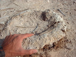
The Conch Bar Caves, located on Middle Caicos, is the largest above-ground cave system in the Bahamas-Turks and Caicos Islands archipelago. [1]

Middle Caicos island

Middle Caicos, also Grand Caicos, is the largest island in the Turks and Caicos Islands. To the west, it is separated from North Caicos by Juniper Hole, and to the east, from East Caicos by Lorimer Creek, both narrow passages that can accommodate only small boats. The island is known for its extensive system of caves and its significant Lucayan Indian archeological sites. The island is connected to North Caicos via a causeway.

Turks and Caicos Islands British Overseas Territory in the Caribbean

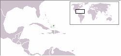
The Turks and Caicos Islands are a British Overseas Territory consisting of the larger Caicos Islands and smaller Turks Islands, two groups of tropical islands in the Lucayan Archipelago of the Atlantic Ocean and northern West Indies. They are known primarily for tourism and as an offshore financial centre. The resident population is 31,458 as of 2012 of whom 23,769 live on Providenciales in the Caicos Islands. It is the third largest of the British overseas territories by population.

The caves are near their namesake village of Conch Bar. In the 1880s, the caves were mined for guano, which was exported as fertilizer. Many markings and etchings have been left by miners in the caves, many with names and dates. It was during this time of excavation that a number of Lucayan artefacts were discovered within the cave system.

Guano excrement of seabirds and bats

Guano is the accumulated excrement of seabirds and bats. As a manure, guano is a highly effective fertilizer due to its exceptionally high content of nitrogen, phosphate and potassium: nutrients essential for plant growth. Guano was also, to a lesser extent, sought for the production of gunpowder and other explosive materials. The 19th-century guano trade played a pivotal role in the development of modern input-intensive farming, but its demand began to decline after the discovery of the Haber-Bosch process of nitrogen fixing led to the production of synthetic fertilizers. The demand for guano spurred the human colonization of remote bird islands in many parts of the world. During the 20th century, guano-producing birds became an important target of conservation programs and influenced the development of environmental consciousness. Today, guano is increasingly sought after by organic farmers.

Fertilizer material of natural or synthetic origin that is applied to soils or leaves to supply plant nutrients for better growth

A fertilizer or fertiliser is any material of natural or synthetic origin that is applied to soils or to plant tissues to supply one or more plant nutrients essential to the growth of plants. Many sources of fertilizer exist, both natural and industrially produced.

The Lucayanpeople were the original inhabitants of the Bahamas before the arrival of European colonizers. They were a branch of the Taínos who inhabited most of the Caribbean islands at the time. The Lucayans were the first inhabitants of the Americas encountered by Christopher Columbus. The Spanish started seizing Lucayans as slaves within a few years of Columbus's arrival, and they had all been removed from the Bahamas by 1520.

Related Research Articles

British West Indies

The British West Indies, sometimes abbreviated to the BWI, is a collective term for the British territories in the Caribbean: Anguilla, Bermuda, the Cayman Islands, Turks and Caicos Islands, Montserrat and the British Virgin Islands. Before the decolonization period in the later 1950's and 1960's it included all British colonies in the region, together with two mainland colonies, as part of the British Empire.

History of the Turks and Caicos Islands

Before European colonization, the Turks and Caicos Islands were inhabited by Taino and Lucayan peoples. The first recorded European sighting of the islands now known as the Turks and Caicos occurred in 1512. In the subsequent centuries, the islands were claimed by several European powers with the British Empire eventually gaining control. For many years the islands were governed indirectly through Bermuda, the Bahamas, and Jamaica. When the Bahamas gained independence in 1973, the islands received their own governor, and have remained a separate autonomous British Overseas Territory since. In August 2009, the United Kingdom suspended the Turks and Caicos Islands' self-government following allegations of ministerial corruption. Home rule was restored in the islands after the November 2012 elections.

Area code 649 is the local telephone area code of the Turks and Caicos Islands. Area 649 was created in a split from the original area code 809, with permissive dialing beginning 31 May 1997 and ending 30 June 1998.

Coat of arms of the Turks and Caicos Islands coat of arms

The coat of arms of the Turks and Caicos Islands was granted in 1965.

South Caicos seventh largest island in the Turks and Caicos islands archipelago

South Caicos is the seventh-largest island in the Turks and Caicos archipelago, with a land area of 21.2 square kilometres. South Caicos is known for excellent fishing, both deep-sea and bone fishing, and scuba diving. South Caicos was formerly a salt exporter, the island still hosts a network of salt pans as a reminder of the industry. Today, the island's main income is derived from small-scale commercial fishing.

East Caicos island

East Caicos is the fourth largest island in the Turks and Caicos Islands. To the west, it is separated from Middle Caicos by Lorimer Creek, a narrow passage that can accommodate only small boats. To the south is South Caicos. East Caicos has no inhabitants.

Cockburn Harbour human settlement in United Kingdom

Cockburn Harbour is a settlement in the Turks and Caicos. It is the largest community on the island of South Caicos, with some 811 people. It has the best natural harbour of the Caicos Islands, and was once an important centre for regional trade and a major exporter of salt. Today its main industries are fishing and tourism.

The Roman CatholicMission Sui Iuris of Turks and Caicos is a mission sui iuris of the Latin Church of the Roman Catholic Church in the Caribbean. The mission encompasses the entirety of the British dependency of Turks and Caicos. The mission is a suffragan of the Archdiocese of Nassau and a member of the Antilles Episcopal Conference.

Ambergris Cay island in the Turks and Caicos Islands

The Ambergris Cays are a group of small islands within the Turks and Caicos Islands. They are situated to the south of the main chain of the Caicos islands. The largest islands are Big Ambergris Cay and Small Ambergris Cay. It was named for valuable deposits of ambergris, a waxy substance that migrating sperm whales secrete, found on the 8 miles (13 km) of shoreline. The island is approximately four miles long, one mile wide, and 1,100 acres (4.5 km2) in total.

Flag of the Turks and Caicos Islands flag

The current flag of the Turks and Caicos Islands was adopted on 7 November 1968, and modified in 1999. Prior to this, the islands had several different flags either proposed or utilised.

Index of Turks and Caicos Islands-related articles

The following is an alphabetical list of topics related to the British Overseas Territory of the Turks and Caicos Islands.

Rugby union in the Turks and Caicos Islands

Rugby union in the Turks and Caicos Islands is a minor, but growing sport.

The Turks and Caicos Islands consist of 30 islands situated in the Atlantic Ocean, southeast of the Bahamas. Local cuisine employs rare species, bananas, citrus, corn and ocean salt. Because the territories are situated in the Caribbean zone and belong to the United Kingdom, many elements from these cultures can be found in the local diet. The variety of meat ranges from fish, fish roe, crabs, and lobster, to poultry, pork and beef. Meat is typically served with local corn, rice and vegetables and is topped with local sauces and spices.

Parade Ground is a multi-use stadium in Cockburn Town, Grand Turk, Turks and Caicos Islands. It is currently used for athletics, cricket, rugby union and football competitions.

Raymond Gardiner High School Playfield is a multi-use sporting facilities in Bottle Creek, North Caicos, Turks and Caicos Islands. It is currently used for athletics, soccer and rugby union competitions.

Turks and Caicos National Museum national museum of the Turks and Caicos Islands

The Turks and Caicos National Museum is the national museum of the Turks and Caicos Islands. It is located in Guinep House on Front Street to the north of Cockburn Town on Grand Turk Island, which is also the capital of the archipelago. Established in the 1980s and opened in 1991, the museum is publicly funded as a nonprofit trust. It exhibits pre-historic Lucayan culture and records the history of the islands of the colonial era and the slave trade, all related to the sea. An arboretum is adjacent to the museum.

Fish Ponds and Crossing Place Trail Important Bird Area

The Fish Ponds and Crossing Place Trail Important Bird Area is a 1024 ha tract of land on the island of Middle Caicos in the Turks and Caicos Islands, a British Overseas Territory in the Lucayan Archipelago of the western Atlantic Ocean. It forms one of the territory’s Important Bird Areas (IBAs).

References

Coordinates: 21°49′34″N71°47′28″W / 21.82611°N 71.79111°W / 21.82611; -71.79111

Geographic coordinate system Coordinate system

A geographic coordinate system is a coordinate system that enables every location on Earth to be specified by a set of numbers, letters or symbols. The coordinates are often chosen such that one of the numbers represents a vertical position and two or three of the numbers represent a horizontal position; alternatively, a geographic position may be expressed in a combined three-dimensional Cartesian vector. A common choice of coordinates is latitude, longitude and elevation. To specify a location on a plane requires a map projection.