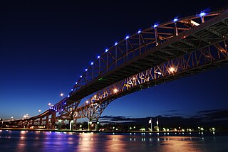
The Blue Water Bridge is a twin-span international bridge across the St. Clair River that links Port Huron, Michigan, United States, and Sarnia, Ontario, Canada. The Blue Water Bridge connects Highway 402 in Ontario with both Interstate 69 (I-69) and Interstate 94 (I-94) in Michigan.

M-86 is an east–west state trunkline highway in the US state of Michigan in the southern portion of the Lower Peninsula. The highway starts at Business US Highway 131 and M-60 in Three Rivers and ends at US Highway 12 (US 12) near Coldwater. In between, it crosses farm country and runs along a section of the Prairie River. Following a highway originally numbered M-7, the roadway was renumbered M-86 in 1940. It has been a part of the state highway system at least since 1927. Two other roadways carried the M-86 designation in the 1920s. Two bridges along the road are eligible for inclusion on the National Register of Historic Places (NRHP).

U.S. Route 12 (US 12) is a part of the United States Numbered Highway System that runs from Aberdeen, Washington, to Detroit, Michigan. In the U.S. state of Indiana, it is part of the state road system. US 12 enters the state concurrent with US 20 and US 41 in Whiting. The 46.258 miles (74.445 km) of US 12 that lie within Indiana serve as a major conduit. Some of the highway is listed on the National Highway System (NHS). Various sections are rural two-lane highway, urbanized four-lane undivided highway, and one-way streets. The easternmost community along the highway is Michiana Shores at the Michigan state line.

US Highway 31 (US 31) is a part of the United States Numbered Highway System that runs from Alabama to the Lower Peninsula of the US state of Michigan. In Michigan, it is a state trunkline highway that runs from the Indiana–Michigan state line at Bertrand Township north to its terminus at Interstate 75 (I-75) south of Mackinaw City. Along its 355.2-mile-long (571.6 km) route, US 31 follows the Michigan section of the St. Joseph Valley Parkway as well as other freeways and divided highways northward to Ludington. North of there, the trunkline is a rural undivided highway through the Northern Michigan tourist destinations of Traverse City and Petoskey before terminating south of Mackinaw City. Along its route, US 31 has been dedicated in memory of a few different organizations, and sections of it carry the Lake Michigan Circle Tour (LMCT) moniker. Four bridges used by the highway have been recognized for their historic character as well.

U.S. Route 20 (US 20) in Indiana is a main east–west highway that is parallel to the Indiana Toll Road. The western terminus of US 20 is at the Illinois state line and the eastern terminus is at the Ohio state line. US 20 through Whiting, East Chicago, and Gary is concurrent with US 12 twice. The route varies between one-way, two-lane, and four-lane streets, in Northwest Indiana. From the east side of Gary to west of South Bend, US 20 is a four-lane undivided highway. The route then heads around the west and south sides of South Bend and Elkhart as a four-lane limited access divided highway. East of State Road 15 (SR 15), US 20 is two-lane rural highway.

The Ten Curves Road–Manistique River Bridge was a bridge carrying Ten Curves Road over the Manistique River in Germfask Township, Michigan. It was listed on the National Register of Historic Places in 1999, and was demolished in 2013.

The Main Street–Black River Bridge is a bridge located on Main Street over the Black River in Ramsay, Bessemer Township, Michigan, USA. It was listed on the National Register of Historic Places in 1999.

The M-28–Tahquamenon River Bridge is a bridge located on M-28 over the Tahquamenon River in Chippewa Township, Michigan. It was listed on the National Register of Historic Places (NRHP) in 1999.
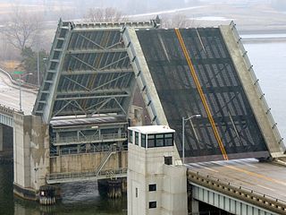
The US 31–Island Lake Outlet Bridge is a double-leaf bascule bridge in downtown Charlevoix in the U.S. state of Michigan. The bridge carries U.S. Highway 31 across Island Lake Outlet that ultimately connects Lake Charlevoix to Lake Michigan.
The Blossomland Bridge is a bascule bridge in St. Joseph, Michigan, that carries M-63 across the St. Joseph River. Delayed by World War II, construction took place from 1947 though 1948. At the time, it was the longest bridge built by the Michigan State Highway Department. The bridge is listed on the National Register of Historic Places.

The Avery Road–Galien River Bridge is a bridge that carried Avery Road over the Galien River near New Troy, Michigan. The year of construction is uncertain, but it was built by 1928. The bridge is listed on the National Register of Historic Places.
The Second Street–Gun River Bridge was a bridge in Martin Township, Michigan, USA. It was demolished in 2012. The bridge was significant as a rare example of a bridge with a plaque stating that it had been built as a result of Michigan's Covert Act. It was also one of the few remaining examples of a camelback highway bridge in Michigan.

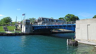
The Cheboygan Bascule Bridge, also known as the State Street Bridge, is a double-leaf bascule bridge in Cheboygan, Michigan, carrying U.S. Highway 23 across the Cheboygan River. Built in 1940, it was the last bascule bridge constructed in the state of Michigan prior to the end of World War II. It replaced an aging swing bridge built in 1877. The bridge is listed on the National Register of Historic Places.

The US 12–St. Joseph River Bridge is a three-span camelback bridge in Mottville, Michigan, that carried U.S. Route 12 across the St. Joseph River. Built in 1922, it is the fourth bridge to cross the river at this location. It has served as a pedestrian bridge since 1990 when a new bridge opened alongside to carry the highway. The bridge is the longest surviving camelback bridge in Michigan. It is a Michigan State Historic Site and is listed on the National Register of Historic Places.

The 23 Mile Road–Kalamazoo River Bridge is a curved-chord through-girder bridge in Marengo Township, Michigan, United States, that carries 23 Mile Road over the Kalamazoo River. Built in 1922, it is listed on the National Register of Historic Places.

The Lincoln Road–Pine River Bridge, also known as the Riverdale Bridge, was a bridge located on Lincoln Road over the Pine River near Seville, Michigan. The architect behind the Lincoln Road–Pine River Bridge was the Michigan State Highway Department and its builder was Walter Willets. The bridge is notable for being a large early example of an arched through girder bridge in Michigan, and for sitting on substantially skewed abutments. It was listed on the National Register of Historic Places in 1999.

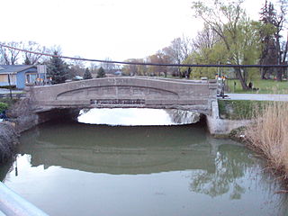
The Crystal Springs Street–Dowagiac River Bridge is a road bridge that carries Crystal Springs Street over the Dowagiac River near Sumnerville, Michigan. It was installed in that location in 2017. Between 1938 and 2016, the bridge was located approximately 50 miles away, and carried M-86 over the Prairie River near Nottawa, Michigan, and was known then as the M-86–Prairie River Bridge. The bridge was listed on the National Register of Historic Places in 2000, and is the last remaining camelback pony truss bridge used on the state trunkline system in Michigan.

The Gillespie Dam Bridge is a through truss bridge spanning the Gila River in Maricopa County, in the U.S. state of Arizona. The bridge was constructed to bypass a concrete apron through the river in front of the Gillespie Dam, which was often closed due to flooding. Construction of the bridge started in 1925 and completed in 1927. From its opening until 1956, the bridge was part of U.S. Route 80 (US 80), a transcontinental highway between San Diego, California and Tybee Island, Georgia. The bridge was restored in 2012 by Maricopa County for the Arizona Centennial and now includes an educational interpretive center for visitors. The bridge became part of Historic US 80 in 2018.
The Vernier Street–Swan Creek Bridge was a historic bridge carrying Vernier Street over Swan Creek in Ira Township, Michigan. It was listed on the National Register of Historic Places in 2000. It was at one time one of the oldest remaining curved-chord though girder bridges, a design unique to the state of Michigan. The bridge was demolished in 2014.
The Wadhams Road–Pine River Bridge was a bridge carrying Wadhams Road over the Pine River in Saint Clair Township, Michigan. It was one of the few remaining multiple-span, curved-chord through girder bridges, a type unique to Michigan. The bridge was demolished in 2007.


