Related Research Articles

Hydrology is the scientific study of the movement, distribution, and management of water on Earth and other planets, including the water cycle, water resources, and environmental watershed sustainability. A practitioner of hydrology is called a hydrologist. Hydrologists are scientists studying earth or environmental science, civil or environmental engineering, and physical geography. Using various analytical methods and scientific techniques, they collect and analyze data to help solve water related problems such as environmental preservation, natural disasters, and water management.

An aquifer is an underground layer of water-bearing permeable rock, rock fractures or unconsolidated materials. Groundwater from aquifers can be extracted using a water well. Aquifers vary greatly in their characteristics. The study of water flow in aquifers and the characterization of aquifers is called hydrogeology. Related terms include aquitard, which is a bed of low permeability along an aquifer, and aquiclude, which is a solid, impermeable area underlying or overlying an aquifer, the pressure of which could create a confined aquifer. The classification of aquifers is as follows: Saturated versus unsaturated; aquifers versus aquitards; confined versus unconfined; isotropic versus anisotropic; porous, karst, or fractured; transboundary aquifer.

A drainage basin is an area of land where all flowing surface water converges to a single point, such as a river mouth, or flows into another body of water, such as a lake or ocean. A basin is separated from adjacent basins by a perimeter, the drainage divide, made up of a succession of elevated features, such as ridges and hills. A basin may consist of smaller basins that merge at river confluences, forming a hierarchical pattern.

Groundwater is the water present beneath Earth's surface in rock and soil pore spaces and in the fractures of rock formations. About 30 percent of all readily available freshwater in the world is groundwater. A unit of rock or an unconsolidated deposit is called an aquifer when it can yield a usable quantity of water. The depth at which soil pore spaces or fractures and voids in rock become completely saturated with water is called the water table. Groundwater is recharged from the surface; it may discharge from the surface naturally at springs and seeps, and can form oases or wetlands. Groundwater is also often withdrawn for agricultural, municipal, and industrial use by constructing and operating extraction wells. The study of the distribution and movement of groundwater is hydrogeology, also called groundwater hydrology.

Hydrogeology is the area of geology that deals with the distribution and movement of groundwater in the soil and rocks of the Earth's crust. The terms groundwater hydrology, geohydrology, and hydrogeology are often used interchangeably.
Streamflow, or channel runoff, is the flow of water in streams and other channels, and is a major element of the water cycle. It is one component of the movement of water from the land to waterbodies, the other component being surface runoff. Water flowing in channels comes from surface runoff from adjacent hillslopes, from groundwater flow out of the ground, and from water discharged from pipes. The discharge of water flowing in a channel is measured using stream gauges or can be estimated by the Manning equation. The record of flow over time is called a hydrograph. Flooding occurs when the volume of water exceeds the capacity of the channel.

Groundwater recharge or deep drainage or deep percolation is a hydrologic process, where water moves downward from surface water to groundwater. Recharge is the primary method through which water enters an aquifer. This process usually occurs in the vadose zone below plant roots and, is often expressed as a flux to the water table surface. Groundwater recharge also encompasses water moving away from the water table farther into the saturated zone. Recharge occurs both naturally and through anthropogenic processes, where rainwater and or reclaimed water is routed to the subsurface.
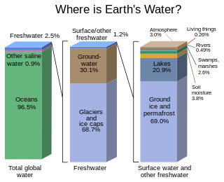
Most water in Earth's atmosphere and on its crust comes from saline seawater, while fresh water accounts for nearly 1% of the total. The vast bulk of the water on Earth is saline or salt water, with an average salinity of 35‰, though this varies slightly according to the amount of runoff received from surrounding land. In all, water from oceans and marginal seas, saline groundwater and water from saline closed lakes amount to over 97% of the water on Earth, though no closed lake stores a globally significant amount of water. Saline groundwater is seldom considered except when evaluating water quality in arid regions.
The Turlock Basin is a sub-basin of the San Joaquin Valley groundwater basin which occupies approximately 13,700 total square miles, making it the largest groundwater basin in California. The Turlock Basin makes up 542 square miles of this total. This aquifer is located within Merced and Stanislaus counties in the Central Valley bounded by the Tuolumne River to the north, the Merced River to the south and San Joaquin River to the west. The Sierra Nevada foothills bound the sub-basin to the east. Groundwater in the San Joaquin Valley occurs mostly in younger alluvial material. The Turlock Basin lies to the east of the city of Turlock. Groundwater in the Turlock Basin occurs in older alluvial deposits. Large portions of the San Joaquin Basin have experienced overdraft of water and infiltration of agricultural water pollutants, resulting in poor water quality.

Surface water is water located on top of land forming terrestrial (inland) waterbodies, and may also be referred to as blue water, opposed to the seawater and waterbodies like the ocean.
Water resources management is a significant challenge for Mexico. The country has in place a system of water resources management that includes both central (federal) and decentralized institutions. Furthermore, water management is imposing a heavy cost to the economy.
MIKE SHE is an integrated hydrological modelling system for building and simulating surface water flow and groundwater flow. MIKE SHE can simulate the entire land phase of the hydrologic cycle and allows components to be used independently and customized to local needs. MIKE SHE emerged from Système Hydrologique Européen (SHE) as developed and extensively applied since 1977 onwards by a consortium of three European organizations: the Institute of Hydrology, SOGREAH (France) and DHI (Denmark). Since then, DHI has continuously invested resources into research and development of MIKE SHE. MIKE SHE can be used for the analysis, planning and management of a wide range of water resources and environmental problems related to surface water and groundwater, especially surface-water impact from groundwater withdrawal, conjunctive use of groundwater and surface water, wetland management and restoration, river basin management and planning, impact studies for changes in land use and climate.
MIKE BASIN is an extension of ArcMap (ESRI) for integrated water resources management and planning. It provides a framework for managers and stakeholders to address multi-sectoral allocation and environmental issues in river basins. It is designed to investigate water sharing issues at international or interstate level, and between competing groups of water users, including the environment. MIKE BASIN is developed by DHI. As of September 2014, MIKE BASIN is no longer available for order or download from DHI. It has been replaced by the application named MIKE HYDRO Basin.

A stream is a continuous body of surface water flowing within the bed and banks of a channel. Depending on its location or certain characteristics, a stream may be referred to by a variety of local or regional names. Long large streams are usually called rivers, while smaller, less voluminous and more intermittent streams are known as streamlets, brooks or creeks.

WAFLEX is a spreadsheet-based model. It can be used to analyse upstream-downstream interactions, dam management options and water allocation and development options.
DPHM-RS is a semi-distributed hydrologic model developed at University of Alberta, Canada.

Hydrology is the science which studies the water cycle as a whole, hence the water exchanges between soil and atmosphere but also between the soil and sub ground (groundwater).
Groundwater banking is a water management mechanism designed to increase water supply reliability. Groundwater can be created by using dewatered aquifer space to store water during the years when there is abundant rainfall. It can then be pumped and used during years that do not have a surplus of water. People can manage the use of groundwater to benefit society through the purchasing and selling of these groundwater rights. The surface water should be used first, and then the groundwater will be used when there is not enough surface water to meet demands. The groundwater will reduce the risk of relying on surface water and will maximize expected income. There are regulatory storage-type aquifer recovery and storage systems which when water is injected into it gives the right to withdraw the water later on. Groundwater banking has been implemented into semi-arid and arid southwestern United States because this is where there is the most need for extra water. The overall goal is to transfer water from low-value to high-value uses by bringing buyers and sellers together.
The Sustainable Groundwater Management Act (SGMA) is a three-bill package that passed the California state legislature and was signed into California state law by Governor Jerry Brown in September 2014. Its purpose is to ensure better local and regional management of groundwater use and it seeks to have a sustainable groundwater management in California by 2042. It emphasizes local management and formed groundwater sustainability agencies (GSAs) from local and regional authorities.
Holly Michael is an American hydrogeologist and Associate Professor of geology at the University of Delaware's College of Earth, Ocean, and Environment.
References
 This article incorporates public domain material from the Congressional Research Service document: Jasper Womach. "Report for Congress: Agriculture: A Glossary of Terms, Programs, and Laws, 2005 Edition" (PDF).
| | This article about geography terminology is a stub. You can help Wikipedia by expanding it. |
| | This ecology-related article is a stub. You can help Wikipedia by expanding it. |