
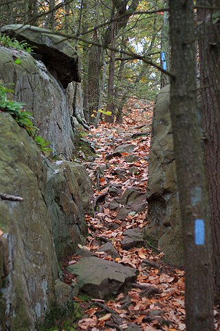
Regicides Trail is a Blue-Blazed hiking trail, about 7 miles (11 km) long, roughly following the edge of a diabase, or traprock, cliff northwest of New Haven, Connecticut. It is named for two regicides, Edward Whalley and his son-in-law William Goffe, who signed the death warrant of King Charles I of England. Upon the restoration of Charles II to the throne and the persecution of the regicides, the pair hid in Judges Cave near the south end of the trail in 1660. The Regicides is widely known to be one of the most technical trails within the CT Blue-Blazed trail system.

The Westwoods Trails is an extensive hiking trail system in Guilford, Connecticut. The trail system has approximately 39 miles (63 km) of trails with features including caves, lakes, streams, rivers, and interesting rock formations. The preserve extends across land owned by the Guilford Land Conservation Trust, which also owns many other land parcels across the town which provide hiking trails, and the State of Connecticut. The trails are accessible for walking, running, and mountain biking. Hunting is only allowed on state land during the season.
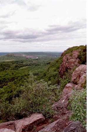
The Metacomet Trail is a 62.7-mile (100.9 km) Blue-Blazed hiking trail that traverses the Metacomet Ridge of central Connecticut and is a part of the newly designated New England National Scenic Trail. Despite being easily accessible and close to large population centers, the trail is considered remarkably rugged and scenic. The route includes many areas of unique ecologic, historic, and geologic interest. Notable features include waterfalls, dramatic cliff faces, woodlands, swamps, lakes, river flood plain, farmland, significant historic sites, and the summits of Talcott Mountain and the Hanging Hills. The Metacomet Trail is maintained largely through the efforts of the Connecticut Forest and Park Association.
The Shenipsit Trail is a Blue-Blazed hiking trail located in Central Connecticut between 3.5 and 7 miles (11 km) east of the Connecticut River. It runs 50 miles (80 km) in a north-south direction. The southern trailhead is on Gadpouch Road in Cobalt, CT on the southern end of the Meshomasic State Forest. The northern trailhead is on Greaves Road past Bald Mountain and the Shenipsit State Forest in Stafford, CT. The trail runs primarily through the Shenipsit and Meshomasic State Forests, and Case Mountain, but also utilizes other public and private land holdings. The Native American name Shenipsit means at the great pool, referring to the Shenipsit Lake, which the trail passes by. The Shenipsit Trail is divided into three sections: South, Central, and North. The Shenipsit Trail is one of the blue-blazed hiking trails managed by the Connecticut Forest and Park Association (CFPA).

The Quinnipiac Trail is a 24-mile (39 km) Blue-Blazed hiking trail in New Haven County, Connecticut. It is the product of the evolution and growth of the first 10.6-mile (17.1 km) trail designated in Connecticut's Blue-Blazed Hiking Trail system, with its light-blue rectangular vertical painted blazes.
The Mattabesett Trail is a 62-mile (100 km) long, hook-shaped blue-blazed hiking trail in central Connecticut and a part of the New England National Scenic Trail. One half of the trail follows the high traprock ridges of the Metacomet Ridge, from Totoket Mountain in Guilford, Connecticut, to Lamentation Mountain in Meriden, Connecticut, from south to north. This ridge is known for its biodiversity, miles of scenic cliffs, and rugged hiking. The second half of the trail extends north from Guilford to Middletown, Connecticut, and ends at the Connecticut River. Here, the trail follows an upland of metamorphic rock with occasional views and dense forests.

The Nipmuck Trail is a Blue-Blazed hiking trail system which meanders through 34.5 miles (55.5 km) of forests in northeast Connecticut. It is maintained by the Connecticut Forest and Park Association and is considered one of the Blue-Blazed hiking trails. There are two southern trail heads in the south of the town of Mansfield, Connecticut. The southwestern terminus is at a road shoulder parking place on Puddin Lane, and the southeastern terminus is a DEEP parking lot on North Windham Road at the southeast corner of Mansfield Hollow State Park. The northern terminus is at the north end of Breakneck Pond along the Massachusetts border in Nipmuck State Forest. Camping permits may be obtained for up to five separate locations for backpacking.
Nestell Kipp "Ned" Anderson (1885–1967) was an American farmer who spearheaded Connecticut's leg of the Appalachian Trail, which currently runs for 50 miles through the northwest corner of the state. In addition to creating and maintaining other area trails for the Connecticut Forest & Park's (CFPA) Blue-Blazed Trail System, he also organized Sherman, Connecticut's first Boy Scout troop in 1931, as well as the Housatonic Trail Club in 1932, for amateur and avid hikers.

The Blue-Blazed Hiking Trail (BBHT) system, managed by the Connecticut Forest & Park Association (CFPA), and the related trail systems documented in the two-volume 19th Edition of the "Connecticut Walk Book" comprise over 800 miles of hiking trails in Connecticut.

The Tunxis Trail is a 79-mile (127 km) Blue-Blazed hiking trail "system" that traverses the western ridge of the central Connecticut Valley. The mainline trail is not completely contiguous, notably there are two gaps of several miles.

The Naugatuck Trail is a 6.8-mile (10.9 km) Blue-Blazed hiking trail "system" in the eastern central-lower Naugatuck River Valley in New Haven County, Connecticut, USA. It is almost entirely contained in the Naugatuck State Forest. The mainline trail is primarily east to west with three short side or spur trails. Composed of four trails, at its western end the trail ends with a section alongside Route 8 and the Naugatuck River. During the 1930s and 1940s, it was much larger. But post–World War II housing developments of the Connecticut Blue-Blazed Trails, led to its drastic reduction.

The Paugussett Trail is a 14-mile (23 km) Blue-Blazed hiking trail "system" in the lower Housatonic River valley in Fairfield County and, today, is entirely in Shelton and Monroe, Connecticut. Much of the trail is in Indian Well State Park and the Town of Monroe's Webb Mountain Park. The mainline trail is primarily southeast to northwest with three short side or spur trails.
The Lillinonah Trail is a 5.9-mile (9.5 km) Blue-Blazed hiking trail "system" in the lower Housatonic River valley in Fairfield County and, today, is entirely in Newtown. Most of the trail is in the upper block of Paugussett State Forest.
This trail system is a part of the Connecticut 400, one of the official Blue-Blazed trails listed in the Connecticut Walk Book by the Connecticut Forest and Park Association (CFPA) and recognized, since 1976, with an award known as the "Connecticut 400 Club" by the Connecticut Chapter of the Appalachian Mountain Club (AMC). In 1976 there were only four hundred miles of Blue-Blazed trail but today (2010) the total length of the trails listed in the CFPA Connecticut Walk Books exceeds 825 miles.

The Peoples State Forest Trails is a system of blue-blazed hiking trails in the Pleasant Valley section of Barkhamsted, Connecticut, United States. The trails, which collectively total 11.22 miles (18.06 km) in length, are entirely within Peoples State Forest.

The Nehantic Trail is a 13-mile (21 km) Connecticut hiking trail and is one of the Blue-Blazed hiking trails maintained by the Connecticut Forest and Park Association.
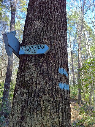
The Natchaug Trail is a Blue-Blazed hiking trail "system" which meanders through 19.5 miles (31.4 km) of forests in northeast Connecticut—primarily in Windham County. It is maintained by the Connecticut Forest and Park Association. Its southern trailhead begins in the James L. Goodwin State Forest in the towns of Chaplin, Connecticut and Hampton, Connecticut and the northern terminus is at its intersection with the Nipmuck Trail in Natchaug State Forest in Eastford, Connecticut.
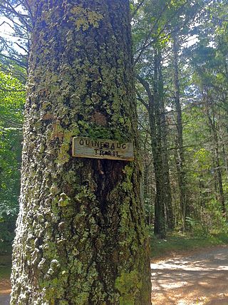
The Quinebaug Trail is a 8.1-mile (13.0 km) Connecticut hiking trail and is one of the Blue-Blazed hiking trails maintained by the Connecticut Forest and Park Association.

The Pequot Trail is a 7.6-mile (12.2 km) Blue-Blazed Trail, a hiking trail maintained by the Connecticut Forest and Park Association.

Quinnipiac River State Park is a public recreation area located in the town of North Haven, Connecticut. The four sections of the state park protect 6 miles (9.7 km) of the Quinnipiac River.
