
U.S. Route 5 (US 5) is a north–south United States Numbered Highway running through the New England states of Connecticut, Massachusetts, and Vermont. Significant cities along the route include New Haven, Connecticut; Hartford, Connecticut; and Springfield, Massachusetts. From Hartford northward to St. Johnsbury, Vermont, the road closely follows the route of the Connecticut River.

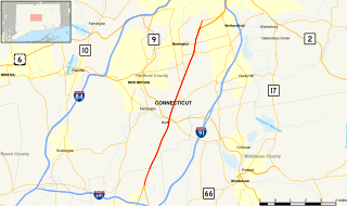
Route 15 is a state highway in the U.S. state of Connecticut that runs 83.53 miles (134.43 km) from a connection with New York's Hutchinson River Parkway in Greenwich, Connecticut, to its northern terminus intersecting with Interstate 84 (I-84) in East Hartford, Connecticut. Route 15 consists of four distinct sections: the Merritt Parkway, the Wilbur Cross Parkway, most of the Berlin Turnpike, and part of the Wilbur Cross Highway. The unified designation was applied to these separate highways in 1948 to provide a continuous through route from New York to Massachusetts. The parkway section of Route 15 is often referred to locally as "The Merritt".

Interstate 195 (I-195), also known as the Saco Industrial Spur, is a short auxiliary Interstate Highway running 1.55 miles (2.49 km) in eastern York County, Maine. The highway, located entirely in the city of Saco, is a nominally east–west route that provides access to downtown Saco and the resort town of Old Orchard Beach from I-95. The western terminus of I-195 is at a trumpet interchange with the Maine Turnpike in central Saco. The route has numbered interchanges with Industrial Park Road, US Route 1 (US 1), and State Route 5 (SR 5) before terminating at an at-grade intersection with SR 5 near the border between Saco and Old Orchard Beach.
State Route 236 is a primary state highway in the U.S. state of Virginia. The state highway runs 15.63 miles (25.15 km) from U.S. Route 29 and US 50 in Fairfax east to SR 400 in Alexandria. SR 236 is a major suburban arterial highway that connects the independent cities of Fairfax and Alexandria via Annandale in Fairfax County. The state highway is known as Main Street in City of Fairfax, Little River Turnpike in Fairfax County, where the highway meets Interstate 495 (I-495), and Duke Street in Alexandria, where the road has junctions with I-395 and US 1.
State Route 420 (SR 420) is a north–south state highway in the northwestern portion of the U.S. state of Ohio. The southern terminus of this four-lane divided highway is at a trumpet interchange with U.S. Route 20/US 23 (US 20/US 23) approximately 3.25 miles (5.23 km) northeast of the village of Luckey. The route’s northern terminus is at the southern terminus of Interstate 280 (I-280), where the two routes meet the Ohio Turnpike (I-80/I-90) at a double-trumpet interchange nearly four miles (6.4 km) southwest of Millbury. SR 420 made its debut in the late 1960s. It is a major route whose primary purpose is to link US 20/US 23 with I-280 and the Ohio Turnpike.

Route 17 is a primary north–south state route beginning in New Haven, through Middletown, and ending in Glastonbury, with a length of 36.33 miles (58.47 km).

Route 66 is an east-west state highway running from Meriden to Windham, serving as an alternate east–west route to U.S. Route 6 through east-central Connecticut.

Route 3 is a 14.45-mile-long (23.26 km) route connecting Middletown to Glastonbury. It passes through the towns of Cromwell, Rocky Hill, and Wethersfield. The northernmost 3 miles (4.8 km) of Route 3 is a freeway that was originally intended for the cancelled Interstate 491.

Route 25 is a 28.59-mile (46.01 km), primary state highway connecting the city of Bridgeport and the town of Brookfield in the U.S. state of Connecticut. Route 25 is a six-lane freeway from Bridgeport to northern Trumbull and a two-lane surface road the rest of the way to Brookfield.
Route 72 is a state highway in the western part of the Greater Hartford area. Route 72 is an L-shaped route with a north–south section in Plymouth and Harwinton and an east–west section from Bristol to New Britain. Route 72 is a freeway from Route 9 in New Britain to Route 372 in Plainville. Although ConnDOT logs it as a north-south route, it is signed as east-west.
The Berlin Turnpike is a 12.17-mile (19.59 km) major thoroughfare carrying U.S. Route 5 and Route 15 in New Haven County and Hartford County in the U.S. state of Connecticut. The road begins one mile south of the Meriden–Berlin town line where Route 15 on the Wilbur Cross Parkway merges with US 5 along North Broad Street in Meriden and terminates at the Wethersfield–Hartford town line. The local name of the street varies as it passes through multiple towns.

The Wilbur Cross Highway is a freeway running along a portion of Connecticut Route 15 and U.S. Route 5 from Wethersfield to East Hartford, Connecticut, and then continuing northeast as a section of Interstate 84, part of which is also cosigned as U.S. Route 6. The freeway ends at a junction with the tolled Massachusetts Turnpike in Sturbridge, Massachusetts. The entire route was formerly signed as Route 15.

Route 99 is a state highway in Connecticut running for 10.64 miles (17.12 km) from Route 9 in Cromwell, through the town of Rocky Hill, ending in Wethersfield at the Hartford city line. The road continues into Hartford as a local road. It follows the former alignment of Route 9 from prior to that route's upgrade to a freeway.

Route 154 is a state highway in Connecticut running for 28.24 miles (45.45 km). It serves as one of the main thoroughfares in the town of Old Saybrook, intersecting twice with U.S. Route 1. North of Interstate 95 (I-95), Route 154 runs parallel to Route 9, along to the west bank of the Connecticut River. The route ends in Higganum at Route 9.
U.S. Route 5 (US 5), a north–south United States Numbered Highway that is generally paralleled by Interstate 91 (I-91), begins at the city of New Haven in Connecticut and heads north through western Massachusetts and eastern Vermont to the international border with Canada. Within Connecticut, US 5 proceeds north from New Haven and passes through Meriden and Hartford toward Springfield, Massachusetts.

State Road 504 (SR 504), also known as the Flatbush Avenue Connector, is a two-lane divided freeway in Connecticut that runs 0.70 miles (1.13 km) within the city of Hartford. Its southern terminus is an intersection with Flatbush Avenue and the northern terminus is the interchange with Interstate 84 (I-84) and U.S. Route 6 (US 6) at exit 45.
Route 173 is a Connecticut state highway in the southern and western suburbs of Hartford, running from Newington to West Hartford.

Route 175 is a state highway in central Connecticut, running from New Britain to Wethersfield.

Route 287 is a Connecticut state highway in the southern Hartford suburbs, running from Newington to Wethersfield. It serves the community of Griswoldville in Wethersfield.

Route 372 is a 14.95-mile (24.06 km) state highway in Hartford and Middlesex counties in central Connecticut, United States, running from Plainville to Cromwell, and serving to communicate between the numerous freeways in the area. The section of Route 372 from Route 10 in Plainville to the Plainville-New Britain town line is designated the Joseph E. Tinty Memorial Highway. The section of Route 372 from the interchange with Route 72 in New Britain to the intersection with Route 71A and SR 571 in Berlin is designated the Polish Legion of American Veterans Memorial Highway.

