Related Research Articles
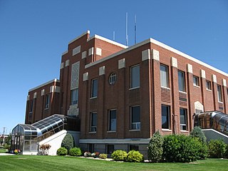
Cassia County is a county in the U.S. state of Idaho. As of the 2020 Census the county had a population of 24,655. The county seat and largest city is Burley. Cassia County is included in the Burley, ID Micropolitan Statistical Area.

Malta is a village in Cassia County, Idaho, United States. The population was 193 at the 2010 census. It is part of the Burley, Idaho Micropolitan Statistical Area.

The Bear River Massacre, or the Engagement on the Bear River, or the Battle of Bear River, or Massacre at Boa Ogoi, took place in present-day Franklin County, Idaho, on January 29, 1863. After years of skirmishes and food raids on farms and ranches, the United States Army attacked a Shoshone encampment gathered at the confluence of the Bear River and Battle Creek in what was then southeastern Washington Territory, near the present-day city of Preston. Colonel Patrick Edward Connor led a detachment of California Volunteers as part of the Bear River Expedition against Shoshone tribal chief Bear Hunter. Hundreds of Shoshone men, women, and children were killed near their lodges; the number of Shoshone victims reported by local settlers was higher than that reported by soldiers.

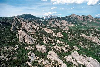
The City of Rocks National Reserve, also known as the Silent City of Rocks, is a United States National Reserve and state park in south-central Idaho, approximately 2 miles (3.2 km) north of the border with Utah. It is widely known for its enormous granite rock formations and excellent rock climbing.
The Snake War (1864–1868) was an irregular war fought by the United States of America against the "Snake Indians," the settlers' term for Northern Paiute, Bannock and Western Shoshone bands who lived along the Snake River. Fighting took place in the states of Oregon, Nevada, and California, and in Idaho Territory. Total casualties from both sides of the conflict numbered 1,762 dead, wounded, or captured.

The Raft River is a 108-mile-long (174 km) tributary of the Snake River located in northern Utah and southern Idaho in the United States. It is part of the Columbia River Basin.

James William Loewen was an American sociologist, historian, and author. He was best known for his 1995 book, Lies My Teacher Told Me: Everything Your American History Textbook Got Wrong.

The Jarbidge River is a 51.8-mile-long (83.4 km), high elevation river in Elko County, Nevada and Owyhee County, Idaho in the United States. The Jarbidge originates as two main forks in the Jarbidge Mountains of northeastern Nevada and then flows through basalt and rhyolite canyons on the high plateau of the Owyhee Desert before joining the Bruneau River.
Almo is a very small unincorporated community in Cassia County, Idaho, United States. It is a short distance away from the City of Rocks National Reserve, a 14,300-acre (58 km2) area with granite columns as much as 600 feet (180 m) high. The ZIP Code for Almo is 83312.

The Burley Micropolitan Statistical Area, as defined by the United States Census Bureau, is an area consisting of two counties in the Magic Valley region of Idaho, anchored by the city of Burley. It is commonly referred to locally as the "Mini-Cassia" area, an amalgam of Minidoka and Cassia Counties.
Cassia National Forest was established as the Cassia Forest Reserve in Idaho by the U.S. Forest Service on June 12, 1905 with 326,260 acres (1,320.3 km2). It became a National Forest on March 4, 1907. On July 1, 1908 it was combined with Raft River National Forest to establish Minidoka National Forest, when the name was discontinued. The land is now part of Sawtooth National Forest.
Minidoka National Forest was established in Idaho and Utah on July 1, 1908 with 736,407 acres (2,980.13 km2) from consolidation of Cassia National Forest and Raft River National Forest, primarily in Idaho. On July 1, 1953 Minidoka was absorbed by Sawtooth National Forest and is now the Sawtooth's Minidoka Ranger District.

The historic 2,170-mile (3,490 km) Oregon Trail connected various towns along the Missouri River to Oregon's Willamette Valley. It was used during the 19th century by Great Plains pioneers who were seeking fertile land in the West and North.

At the outbreak of the American Civil War, Oregon also raised the 1st Oregon Cavalry that was activated in 1862 and served until June 1865. During the Civil War, emigrants to the newfound gold fields in Idaho and Oregon continued to clash with the Paiute, Shoshone and Bannock tribes of Oregon, Idaho and Nevada until relations degenerated into the bloody 1864 - 1868 Snake War. The 1st Oregon Volunteer Infantry Regiment was formed in 1864 and its last company was mustered out of service in July 1867. Both units were used to guard travel routes and Indian reservations, escort emigrant wagon trains, and protect settlers from Indian raiders. Several infantry detachments also accompanied survey parties and built roads in central and southern Oregon.

The Albion Mountains are a mountain range in the U.S. states of Idaho (~99%) and Utah (~1%), spanning Cassia County, Idaho and barely reaching into Box Elder County, Utah. The highest point in the range is Cache Peak at 10,339 feet (3,151 m), and the range is a part of the Basin and Range Province. Most of the mountains are part of the Albion Division of the Minidoka Ranger District of Sawtooth National Forest.
Cache Peak, at 10,339 feet (3,151 m) above sea level, is the highest peak in the Albion Mountains of Cassia County in Southern Idaho. Cache Peak is located in the central part of the range southeast of Oakley and north of Almo in the Albion Division of the Minidoka Ranger District of Sawtooth National Forest.
The six national parks, reserves, historic sites, and monuments in Idaho contain a wide variety of interesting places and experiences. These include recreational areas, archeological sites, nature preserves and volcanic parks.
References
- ↑ Boone, L: Idaho Place Names - A Geographical Dictionary, page 89. University of Idaho Press, 1988.
- ↑ Walgamott, C: Six Decades Back - A Series of Historical Sketches of Early Days in Idaho, pages 122-26. The Caxton Printers Ltd., 1936.
- ↑ Loewen, James W. "Lies Across America - What Our Historic Sites Get Wrong", pages 75-79, Touchstone (Simon and Schuster), New York, 2000.